Situation Summary
Ivory Coast remains a mid-range global security concern (rank #93, composite score 15) with a complex regional risk profile dominated by the northern border districts. The most recent verified security development—a 23 July 2026 government security review—reported improvement in home invasions, commercial robberies, and armed attacks, though assassinations, vehicle theft, and serious road accidents remain flagged concerns. Three event signals on the GEOBIT platform (26–24 July) point to political and governance tensions, but underlying data corroboration remains limited. Overall trajectory is stable but fragmented by significant north-south geographic variance.
Key Developments
- Abidjan, 23 July 2026 — National Security Council reported declining rates of home invasions, commercial robberies, and roadside armed attacks; assassinations and vehicle theft persist as priority concerns.
- Nationwide, 23 July 2026 — Anti-illegal-mining operations continued with 8,500+ clandestine sites cleared since 2021; enforcement activity ongoing but represents cumulative effort rather than acute incident.
- 26 July 2026 — GEOBIT platform flagged rejection event involving Ivorian actors and presidency; corroboration pending.
- 26 July 2026 — Japanese public statement registered on GEOBIT; operational context unclear from available sources.
- 24 July 2026 — Demonstration/rally event tied to governance noted; scope and location not yet specified in verified reporting.
Note: Web-sourced corroboration for events flagged on 24–26 July remains incomplete. No acute security incidents (protests, clashes, infrastructure disruption, travel warnings) have been independently verified in the last 48 hours.
Highest-Risk Areas
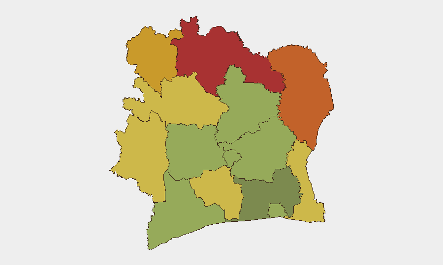
The northern savanna and forest-savanna transition zones—Savanes, Zanzan, Denguélé, and Comoé districts—drive the composite risk ranking, with scores ranging from 70 to 78. These regions face persistent pressures from cross-border militia activity, artisanal mining operations, and weaker state security presence. Montagnes and Woroba districts (scores 68, 65) extend this northern corridor risk southward. By contrast, Abidjan and the southern coastal districts (scores 45–52) show substantially lower risk despite urbanization and crime challenges, suggesting that northern border instability—rather than metropolitan crime—is the primary geographic driver of national risk.
How GeoBit Would Assist
Security teams should leverage AOI Monitoring & Early Warning on Savanes, Zanzan, and Denguélé districts to establish persistent watch and automated alerting on militia movement, mining operations, and cross-border activity. OSINT fusion (combining X/Twitter, Telegram, local news, and radio SIGINT) would improve corroboration of the 24–26 July event signals and clarify political/governance tensions now flagged but unverified. Conflict & Military battle mapping and Network & Actor Analysis would support identification of armed group presence and organizational structure in the northern districts, enabling targeted route planning and asset protection.
7-Day Outlook
No acute escalation is signaled for the immediate week. Political tensions (reflected in recent event flags) warrant close monitoring but lack current corroboration of mass mobilization or security force response. Northern border districts will likely remain under endemic pressure from cross-border militias and mining activity; southern and coastal regions should remain stable. Routine crime risks (theft, road accidents, assassinations) will persist at current baselines absent new trigger events.
Highest-Risk Areas — Ranked
| # | State / Region | Risk |
|---|---|---|
| 1 | Savanes District | 78 |
| 2 | Zanzan District | 75 |
| 3 | Denguélé District | 72 |
| 4 | Comoé District | 70 |
| 5 | Montagnes District | 68 |
| 6 | Woroba District | 65 |
| 7 | Gôh-Djiboua District | 60 |
| 8 | Sassandra-Marahoué District | 58 |
| 9 | Vallée du Bandama District | 55 |
| 10 | Bas-Sassandra District | 52 |
| 11 | Lacs District | 48 |
| 12 | Abidjan | 45 |
Sources
Previous Daily Briefs
A new Ivory Coast brief is written every day — each with its own risk map and downloadable CSV. Here's the last week; use the calendar to go further back.
📅 Browse every day by calendar →
Highlighted days have a brief. Tap a day for that day's map & analysis, or “csv” for that day's dataset ($5).
Atlas — our AI intelligence desk — emails them this snapshot personally. Nothing else, no list.