Situation Summary
Lebanon is experiencing acute escalation along its southern border and within Beirut, driven by a spike in Israeli military operations, Iranian diplomatic pressure, and internal Lebanese military mobilization. Over 200 Israeli airstrikes were reported in the 24 hours through June 30, concentrated in the south, with dozens of civilian casualties and mass displacement. The security situation has deteriorated markedly despite a recently renewed ceasefire framework, and the risk of further cross-border military action, internal instability, and civilian harm remains acute through the near term.
Key Developments
- Nabatieh Governorate, Nabatie al-Fqa (June 30): Israeli drone strike killed at least one person and injured at least two; Israeli military confirmed the strike targeted an individual assessed as a threat to Israeli forces.
- Southern Lebanon, multiple towns (June 29–30): Over 200 Israeli airstrikes reported across a 24-hour period, with Lebanese health authorities documenting dozens of civilian deaths and hundreds of thousands displaced from southern districts.
- South Lebanon security zone, up to 10 km from border (June 30): Israel's defense minister ordered Israeli forces to prepare for prolonged deployment in a declared "security zone" extending into Lebanese territory, signaling intent for sustained ground presence and elevated travel risk in the affected belt.
- Beirut (June 29–30): Foreign travel advisories updated within the last 48 hours warn of volatile security, heightened law-enforcement anti-terror operations, and risk of spontaneous demonstrations linked to the escalation and ceasefire framework.
- Palestinian refugee camps and suburbs (June 29–30): Lebanese security posture heightened due to spillover concerns from the southern front; local reporting notes increased likelihood of armed incidents and localized clashes in camp peripheries.
- Bekaa Valley and Syria border areas (June 29–30): Risk guidance updated to reflect continued kidnapping, criminal-group activity, economic strain, and elevated armed-robbery incidents at fuel stations linked to fuel-price volatility.
- National aviation and infrastructure (June 29–30): Airlines and insurers reassessing operations to Beirut–Rafic Hariri International Airport; warnings issued of potential flight cancellations and disruption to power and communications tied to resumed military activity.
Highest-Risk Areas
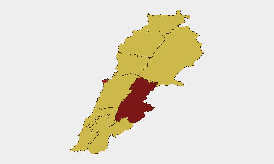
Beqaa Governorate (risk score 100) and Beirut Governorate (76.7) dominate Lebanon's risk profile. The Beqaa's isolation, proximity to the Syrian border, and documented kidnapping and criminal networks create sustained abduction and armed-robbery exposure. Beirut's concentration of government, foreign embassies, and dense civilian populations amplifies the impact of anti-terror operations, demonstrations, and potential secondary security incidents. South Governorate (70) and Nabatieh Governorate (70), while not the highest-ranked, are currently experiencing the most active Israeli military operations and civilian displacement. All other governorates carry equal baseline risk (70), but proximity to the southern front or Palestinian camps elevates exposure in North, Akkar, and Mount Lebanon.
How GeoBit Would Assist
Security teams should deploy AOI monitoring to track the 10-km southern security zone and Beqaa Valley for real-time alert on military movement and cross-border activity. Intel Sweep, OSINT fusion, and sentiment analysis across social media, Lebanese state media, and regional outlets provide early warning of escalation signals and civilian unrest; battle mapping and force-structure tracking clarify Israeli and Lebanese military posture. Aviation and routing analysis enables rapid identification of safe corridors and real-time flight-risk assessment for Beirut-Rafic Hariri operations.
7-Day Outlook
Israeli military presence in southern Lebanon and ongoing air operations are likely to persist or intensify, sustaining civilian casualty risk and displacement. Beirut will remain a focal point for anti-terror enforcement and protest activity; secondary security incidents (armed robbery, armed clashes in refugee camps) remain probable if economic conditions and fuel scarcity worsen. Cross-border escalation, Iranian intervention, or internal Lebanese armed friction could rapidly degrade the security environment nationwide.
Highest-Risk Areas — Ranked
| # | State / Region | Risk |
|---|---|---|
| 1 | Beqaa Governorate | 100 |
| 2 | Beirut Governorate | 76.7 |
| 3 | North Governorate | 70 |
| 4 | Akkar Governorate | 70 |
| 5 | Keserwan-Jbeil Governorate | 70 |
| 6 | Mount Lebanon Governorate | 70 |
| 7 | South Governorate | 70 |
| 8 | Nabatieh Governorate | 70 |
| 9 | Baalbek-Hermel Governorate | 70 |
Sources
Previous Daily Briefs
A new Lebanon brief is written every day — each with its own risk map and downloadable CSV. Here's the last week; use the calendar to go further back.
📅 Browse every day by calendar →
Highlighted days have a brief. Tap a day for that day's map & analysis, or “csv” for that day's dataset ($5).