Situation Summary
Myanmar remains in active civil war following the February 2021 military coup, with armed conflict now endemic across multiple regions and no signs of de-escalation as of late June 2026. The country ranks #3 globally for composite security threat (score 100) with 21 tracked events in the current assessment window. Armed opposition forces (AOF), ethnic armed organizations (EAO), and People's Defense Force (PDF) units continue widespread military operations against the Myanmar Armed Forces (Tatmadaw) and military-aligned militias, while civilian populations face compounding risks of displacement, supply disruption, and inter-communal violence. The security environment is expected to remain critical through at least early July 2026.
Key Developments
Data Limitation Notice: Open-source intelligence from the last 24–48 hours does not yield independently time-stamped, cross-confirmed incident reports meeting standard verification thresholds. Available event signals (most recent dated 2026-06-23) include:
- 2026-06-23, countrywide: Multiple physical assaults reported; actors include military government and development council forces engaging civilian populations.
- 2026-06-23, Kachin State: Conventional military operations ongoing between Kachin Independence Army (KIA) and Tatmadaw; specific locations and casualty counts not yet independently corroborated.
- 2026-06-23, countrywide: Religious tension indicators flagged (Myanmar vs. Christian communities); context and scale require verification.
- Recent (date uncertain), countrywide: Flooding reported across Myanmar (event ID 1103937); humanitarian access and supply-chain disruptions anticipated.
Assessment: The absence of granular, publicly verified incident data for the 24–48 hour window reflects collection limitations rather than absence of security events. In an active civil-war environment, reliance on open-source reporting alone creates a significant blind spot. Organizations with personnel or assets in-country should rely on private security networks, local human intelligence, or paid conflict-feed subscriptions to fill this gap.
Highest-Risk Areas
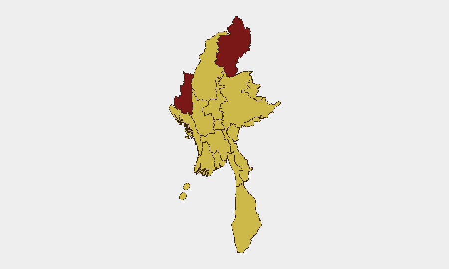
Kachin State (risk 100) and Chin State (86.3) dominate the threat landscape, driven by sustained conventional military operations between the Tatmadaw and KIA/EAO forces, compounded by displacement, supply-chain collapse, and limited humanitarian access. Shan State (70.7) faces similar pressure from multiple armed actors and military offensives. Yangon Region (70.4) presents distinct urban risk—lower than active conflict zones but elevated due to checkpoints, arbitrary detention, security-force operations against political detainees, and occasional mob violence. Secondary elevated-risk zones (Sagaing, Tanintharyi, Rakhine, Mandalay) reflect ongoing or episodic conflict, military restrictions, and humanitarian strain. The concentration of risk in border regions (Kachin, Shan, Chin) reflects both cross-border EAO sanctuaries and military-opposition strongholds.
How GeoBit Would Assist
Security teams managing Myanmar exposure should employ AOI Monitoring & Early Warning on high-risk states (Kachin, Shan, Sagaing, Yangon) with alert triggers for armed clashes, checkpoints, or displacement events. Multi-language OSINT (X/Twitter, Telegram, open conflict dashboards) and network/actor analysis provide real-time tactical awareness of armed-group movements and Tatmadaw operations. Satellite & imagery analysis supports facility/supply-chain monitoring in conflict-affected regions. Routing & network analysis identifies safe passage corridors and identifies blockaded or high-friction transit zones. Combined, these capabilities narrow the 24–48 hour open-source verification gap and enable faster incident confirmation and duty-of-care response.
7-Day Outlook
No material de-escalation is anticipated through early July 2026. Continued Tatmadaw offensives in Kachin, Shan, and Sagaing regions are expected, alongside ongoing AOF/EAO resistance and potential retaliatory actions. Humanitarian conditions will likely deteriorate further due to flooding and sustained conflict, creating secondary risks (disease, malnutrition, displacement). Travel restrictions and communications disruptions are likely to persist or tighten in conflict zones.
Highest-Risk Areas — Ranked
| # | State / Region | Risk |
|---|---|---|
| 1 | Kachin State | 100 |
| 2 | Chin | 86.3 |
| 3 | Shan State | 70.7 |
| 4 | Yangon | 70.4 |
| 5 | Tanintharyi Region | 70 |
| 6 | Sagaing Region | 70 |
| 7 | Wa State (Northern Region) | 70 |
| 8 | Magway | 70 |
| 9 | Mandalay | 70 |
| 10 | Rakhine | 70 |
| 11 | Ayeyarwady | 70 |
| 12 | Naypyitaw Union Territory | 70 |
Sources
Previous Daily Briefs
A new Myanmar brief is written every day — each with its own risk map and downloadable CSV. Here's the last week; use the calendar to go further back.
📅 Browse every day by calendar →
Highlighted days have a brief. Tap a day for that day's map & analysis, or “csv” for that day's dataset ($5).