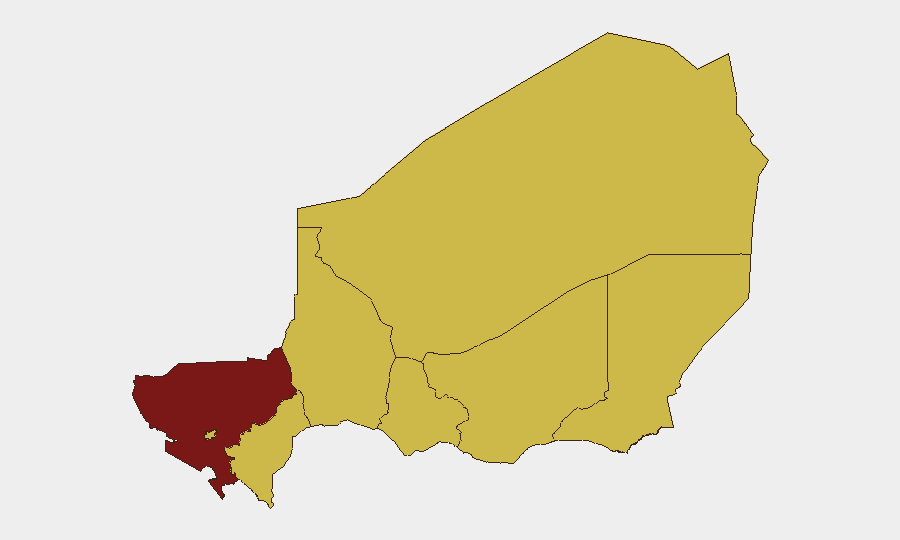
Situation Summary
Niger remains at composite threat rank #21 globally (89/100) with persistent jihadist activity concentrated in the Tillabéri Region and secondary pressure across the Sahel belt. Recent signals indicate cross-border spillover from Nigeria and diplomatic friction with regional/international actors, though no confirmed new security incidents in Niger have been reported in the last 24–48 hours. The threat environment is characterized by recurring ISSP and JNIM operations against military infrastructure rather than acute destabilization, and the near-term trajectory suggests sustained low-to-moderate pressure without imminent escalation.
Key Developments
No verified incidents meeting the 24–48-hour criterion have been reported. The most recent confirmed Niger-specific security events are:
- June 25, 2026 (analytical report): IS Sahel Province conducted coordinated attacks on military bases at Inates and Banibangou in Tillabéri Region on June 17, 2026, targeting Niger Armed Forces positions; follow-on casualty or tactical updates remain unverified.
- June 25, 2026 (analytical report): JNIM launched an attempted incursion against Diori Hamani Airport (near Niamey) on June 18, 2026; airport remains operational; no aircraft or civilian casualties reported.
Diplomatic/Political Signal Activity (June 28–30): Nigerian government statements and African Union/French diplomatic messaging concerning Niger have been recorded (public statements, relation reductions), but these relate to cross-border governance and alliance posture rather than localized Niger security incidents. No direct civil unrest, protest activity, or new armed-group operations in Niger towns or regions have been independently verified in the last 48 hours.
Highest-Risk Areas
Tillabéri Region dominates the sub-national risk profile (92.4/100), driven by sustained ISSP presence, proximity to Mali, and proven capability to strike military and civilian infrastructure. Tahoua, Agadez, Zinder, and Diffa regions (all 62.4–67.4 range) reflect secondary jihadist activity and transnational militant infiltration along supply lines and ungoverned borders. Niamey itself is ranked equal to secondary zones (62.4), indicating perceived asymmetric threat to the capital (airport, government sites), though operational tempo remains lower than in the far northwest. Dosso and Maradi regions, though similarly scored, show less recent incident density and are lower immediate priorities.
How GeoBit Would Assist
A security team with personnel or assets in Niger should employ AOI Monitoring & Early Warning on Tillabéri, Tahoua, and the Niamey perimeter to detect upticks in militant activity or checkpoint expansion before they impact operations. Multi-language OSINT and X/Twitter OSINT on jihadist group messaging, recruitment claims, and casualty announcements will provide 24–48-hour lead indicators ahead of press confirmation. Battle Mapping and Force Structure tracking of Niger Armed Forces deployments and ISSP/JNIM disposition will clarify which routes, towns, and supply chains remain contested or passable.
7-Day Outlook
Jihadist tempo in Tillabéri is likely to remain episodic rather than surge-driven over the next week, barring leadership changes or external reinforcement from Mali. Diplomatic messaging between Niger and neighboring states may intensify, but such rhetoric typically does not translate immediately to ground-level security degradation. Personnel and asset security plans should assume baseline ISSP/JNIM harassment capability in the north and maintain heightened awareness around government sites in Niamey.
Highest-Risk Areas — Ranked
| # | State / Region | Risk |
|---|---|---|
| 1 | Tillabéri Region | 92.4 |
| 2 | Tahoua Region | 67.4 |
| 3 | Agadez Region | 62.4 |
| 4 | Zinder Region | 62.4 |
| 5 | Diffa Region | 62.4 |
| 6 | Niamey | 62.4 |
| 7 | Dosso Region | 62.4 |
| 8 | Maradi Region | 62.4 |
Sources
Previous Daily Briefs
A new Niger brief is written every day — each with its own risk map and downloadable CSV. Here's the last week; use the calendar to go further back.
📅 Browse every day by calendar →
Highlighted days have a brief. Tap a day for that day's map & analysis, or “csv” for that day's dataset ($5).