Situation Summary
Panama's composite threat score of 35 (global rank #51) reflects sustained gang and organized-crime pressure, particularly in border and transit zones. While no major security incidents were recorded in the last 24 hours, recent events—including large-scale gang raids, drug interdictions, and a spike in homicides in San Miguelito—underscore endemic violence linked to drug trafficking and territorial control. Infrastructure disruptions (Panama Canal transit cuts, Corredor Sur construction) are compounding travel and supply-chain risk. Weather advisories and court sentencing activity round out the current operational environment.
Key Developments
- Panama Canal transit reduction (2026-08-21): The Canal Authority announced progressive cuts to daily transits effective early September—Neopanamax slots to 9/day, Panamax from 25 to 23/day—due to El Niño-driven drought. This is a significant supply-chain and economic risk affecting corporate logistics and travel schedules.
- Corredor Sur infrastructure works (2026-08-21 to 23, Panama City): Daily partial closures and inverted lanes (21:00–05:00) on the main expressway due to Costa del Este interchange expansion; heavy traffic and route delays expected through August 23.
- San Miguelito homicide spike and curfew (through 2026-08-18, Panamá Province): Approximately 75 homicides recorded by mid-August prompted San Miguelito District to impose night-time mobility restrictions, signaling localized surge in gang-related lethal violence.
- Colón Province violent crime wave (2026-08-21, Colón Province): Reports of a young man killed by gunfire in Río Alejandro sector (Puerto Pilón) and ongoing violent incidents in Colón City (Calle 10, Avenida Domingo Díaz) characterize a sustained "ola de criminalidad" in the high-risk province.
- National police enforcement surge (through 2026-08-21): 202 arrests, 65 search warrants, 26 drug packages, ~USD 88,000 cash, and 9 firearms seized in recent multi-location operations; indicates elevated policing activity and potential checkpoint/mobility impacts on key routes.
- Weather advisory (2026-08-22 to 24, nationwide): Meteorological institute issued vigilance notice for heavy rain, thunderstorms, and strong winds; raises flooding, landslide, and hazardous-driving risk across Panama.
- Transnational arrest (2026-08-21, Cartagena, Colombia): Eduardo Glicerio Rogers Mojica, a Panamanian wanted in connection with a 2021 homicide in Colón, arrested by Colombian and Interpol Panama authorities; reflects ongoing cross-border gang and criminal activity.
Highest-Risk Areas
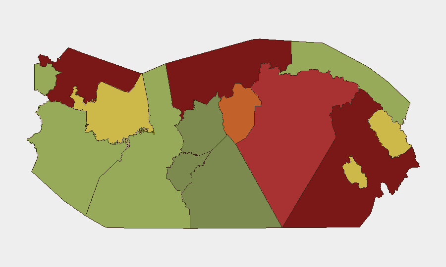
Darién (risk 95), Colón (88), and Bocas del Toro (82) dominate the sub-national ranking, driven by trafficking, gang presence, and limited state control. Darién and Bocas del Toro serve as drug-transit corridors from Colombia; Colón combines port-smuggling vulnerabilities with urban gang violence (evident in the current Río Alejandro and Colón City incidents). Panamá Province (78) and Panamá Oeste (75)—which include San Miguelito and the capital corridor—are elevated by homicide clusters and organized-crime territorial disputes. Inland autonomous regions (Ngäbe-Buglé, Emberá-Wounaan) carry moderate-to-high risk from trafficking activity and limited governance.
How GeoBit Would Assist
Intel Sweep & OSINT Fusion would monitor gang communications, trafficking patterns, and law-enforcement operations in real time across Colón, Darién, and Bocas del Toro to flag emerging territorial disputes or cartel movements. AOI Monitoring & Early Warning would track the San Miguelito and Colón City violence clusters and alert when incidents concentrate near corporate or expatriate assets. Routing & Network Analysis would dynamically model safe transit corridors around Corredor Sur construction, police checkpoints, and high-homicide zones, enabling duty-of-care teams to adjust travel protocols and evacuation planning.
7-Day Outlook
Colón's crime wave and San Miguelito's elevated homicide rate are likely to persist through late August absent major enforcement escalation. Canal transit cuts and road works will continue to disrupt logistics and mobility until early September. Weather systems may temporarily elevate natural hazard risk and further constrain movement; security teams should anticipate multi-day operational friction on travel, supply-chain, and checkpoint management.
Highest-Risk Areas — Ranked
| # | State / Region | Risk |
|---|---|---|
| 1 | Darién | 95 |
| 2 | Colón | 88 |
| 3 | Bocas del Toro | 82 |
| 4 | Panamá Province | 78 |
| 5 | Panamá Oeste | 75 |
| 6 | Ngäbe-Buglé | 68 |
| 7 | Emberá-Wounaan | 62 |
| 8 | Veraguas | 58 |
| 9 | Chiriquí | 48 |
| 10 | Naso Tjër Di | 45 |
| 11 | Guna Yala | 42 |
| 12 | Coclé | 35 |
Sources
Previous Daily Briefs
A new Panama brief is written every day — each with its own risk map and downloadable CSV. Here's the last week; use the calendar to go further back.
- August 21, 2026
- August 20, 2026
- August 19, 2026
- August 18, 2026
- August 17, 2026
- August 16, 2026
- August 15, 2026
📅 Browse every day by calendar →
Highlighted days have a brief. Tap a day for that day's map & analysis, or “csv” for that day's dataset ($5).
Atlas — our AI intelligence desk — emails them this snapshot personally. Nothing else, no list.