Situation Summary
Somalia remains in active conflict with Al‑Shabaab, characterized by distributed militant networks, inter-clan violence, and state fragmentation. Over the past 48 hours, security forces have conducted coordinated raids against Al‑Shabaab infrastructure while separate incidents of mortar shelling and clan fighting underscore the multi-front nature of instability. The security environment shows no signs of de-escalation, with heightened military mobilization and international partner involvement evident across multiple regions.
Key Developments
- Miirtaqwo, Middle Shabelle (25 July, reported 26 July): NISA forces destroyed an Al‑Shabaab compound housing Radio Andalus equipment, killing the network's chief Abdisamad Mohamed and operative Ali Salad. The strike targeted the group's propaganda infrastructure as part of a broader dismantling effort.
- Tardo, Hiiraan Region (25 July, reported 26 July): NISA operations targeted Al‑Shabaab militants staged for attacks on Goobo and Waabweyn, killing additional fighters and destroying at least one vehicle in coordinated strikes.
- Baidoa, South West State (late July, reported within 48h): Mortar shelling occurred during South West State inauguration events; Turkish F‑16s were subsequently reported deployed to the region, though the Somali Defence Ministry revised initial attribution language to credit "international partners" for recent strikes.
- Jalalaqsi, Hiiraan Region (ongoing, reported 24–48h ago): Clan fighting continued for a second consecutive day, indicating sustained inter-clan violence independent of Al‑Shabaab activity.
- Jowhar, Middle Shabelle (30 July): AUSSOM Sector 5 and Somali security forces conducted patrols around Sabuun Bridge east of Jowhar Airfield to prevent Al‑Shabaab movement across the crossing; civilian traffic remained unaffected.
- Mogadishu, NISA Headquarters (late July, reported 24–48h ago): Heavy security deployment was observed around intelligence agency headquarters, reflecting heightened tensions following recent militant activity and political friction.
Highest-Risk Areas
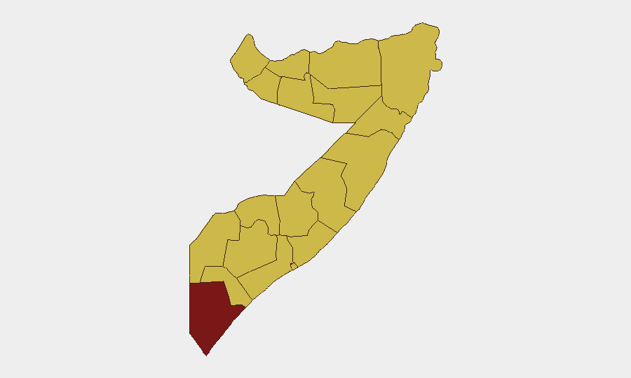
Lower Juba stands distinctly above all other regions (97.1) and warrants primary attention; the remaining 11 tracked states cluster at 67.1, indicating either plateau-level endemic conflict or data-aggregation effects. Lower Juba's elevation likely reflects prolonged Al‑Shabaab presence and cross-border activities with Kenya. The secondary tier—Awdal, Woqooyi Galbeed, Gedo, Bakool, Bay, Middle Juba, Lower Shabelle, Sahil, Togdheer, Hiiraan, and Middle Shabelle—are all classified as high-risk zones. Recent intelligence operations in Middle Shabelle and Hiiraan (raids on 25 July) confirm active militant networks; Baidoa's mortar shelling underscores South West State instability; and Jalalaqsi's inter-clan fighting demonstrates that threat sources extend beyond organized insurgency.
How GeoBit Would Assist
Security teams should employ AOI Monitoring & Early Warning to track Mogadishu, Baidoa, Jowhar, and Lower Juba for sustained situational awareness. Conflict & Military mapping paired with Network & Actor Analysis would provide granular visibility into Al‑Shabaab cell locations, leadership, and propaganda networks following the recent raids. Multi-language OSINT Fusion and Telegram/X OSINT monitoring would capture real-time reporting on clan clashes, military movements, and international partner activities that precede formal announcements.
7-Day Outlook
Intensified counter-militant operations suggest security forces are maintaining pressure on Al‑Shabaab networks, though the group's decentralized structure limits the durability of tactical gains. Inter-clan violence in Hiiraan and political tensions around South West State inauguration create parallel instability vectors unrelated to organized terror. Over the next seven days, expect continued military mobilization, possible additional raids, and elevated security postures in Mogadishu and key regional capitals, with heightened risk of collateral civilian impact during operations.
Highest-Risk Areas — Ranked
| # | State / Region | Risk |
|---|---|---|
| 1 | Lower Juba | 97.1 |
| 2 | Awdal | 67.1 |
| 3 | Woqooyi Galbeed | 67.1 |
| 4 | Gedo | 67.1 |
| 5 | Bakool | 67.1 |
| 6 | Bay | 67.1 |
| 7 | Middle Juba | 67.1 |
| 8 | Lower Shabelle | 67.1 |
| 9 | Sahil | 67.1 |
| 10 | Togdheer | 67.1 |
| 11 | Hiiraan | 67.1 |
| 12 | Middle Shebelle | 67.1 |
Sources
Previous Daily Briefs
A new Somalia brief is written every day — each with its own risk map and downloadable CSV. Here's the last week; use the calendar to go further back.
📅 Browse every day by calendar →
Highlighted days have a brief. Tap a day for that day's map & analysis, or “csv” for that day's dataset ($5).
Atlas — our AI intelligence desk — emails them this snapshot personally. Nothing else, no list.