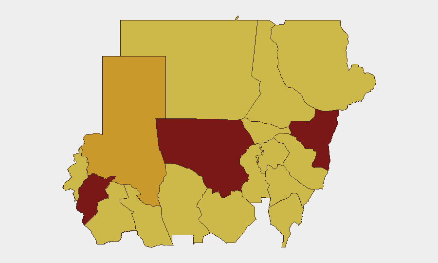
Situation Summary
Sudan remains in active civil war with composite threat ranking at #7 globally (116 tracked events). The last 48 hours show intensifying military operations across multiple fronts—SAF advances in West Darfur and Blue Nile, continued RSF drone and air strikes against civilian infrastructure in North Kordofan, and a sharp uptick in armed activity in the disputed Abyei area. Humanitarian access is deteriorating as supply routes close and drone strikes continue at elevated levels, with over 1,000 civilian deaths from aerial attacks in the first five months of 2026 alone.
Key Developments
- El Obeid, North Kordofan (3–4 July): UN Human Rights Commissioner reported relentless RSF and SAF drone strikes hitting markets, schools, fuel stations, water infrastructure, and civilian vehicles; RSF has tightened control of exit routes except from the east, effectively choking civilian movement.
- Kurmuk, Blue Nile state (3–4 July): SAF intensified offensive to retake the strategic border town from RSF-aligned forces, with renewed air and artillery strikes reported around Kurmuk and nearby villages.
- West Darfur/Geneina corridor (4 July): SAF-allied forces captured a key RSF logistical hub and cut a major RSF supply route feeding Geneina from Chad after a week of cross-border clashes; humanitarian monitors warning of further aid disruption.
- Port Sudan, Red Sea state (4 July): Counter-narcotics raid on criminal network in Libya Market resulted in gunfire exchange—two suspects killed, two officers wounded; control of area subsequently restored.
- Abyei area (3–4 July): RSF elements remain deployed around Goli and Diffra with sharp increases in security incidents, unauthorized checkpoints, and armed activity in recent days, signaling potential spillover from main conflict theater into disputed territory.
- Urban security incidents (late June–4 July): SAF-held cities experienced multiple incidents prompting authorities to review mandate and deployment of military-allied joint force tasked with urban security, following reports of civilian abuses.
- Nationwide drone trend (reported 3–4 July): OHCHR briefing to UN Security Council confirmed over 1,000 civilian deaths from drone strikes January–May 2026 (approximately 80% of conflict-related civilian deaths), with sharp increase in recent weeks.
Highest-Risk Areas
North Kordofan (risk 100) remains the most dangerous state, driven by relentless dual-force drone and artillery strikes on civilian infrastructure and exit routes. Central Darfur (88.9) and Kassala (83.5) follow, but West Darfur—though not among the top-ranked regions—is now a critical secondary hotspot following SAF advances cutting RSF supply lines and intensifying territorial competition near the Chad border. The Abyei disputed territory presents emerging risk of conflict spillover from the main theater. Across the board, cities and towns under SAF control are experiencing internal security deterioration due to joint-force abuses, while RSF-controlled areas face unrelenting aerial bombardment.
How GeoBit Would Assist
Organizations with personnel or assets in Sudan should employ AOI Monitoring & Early Warning on high-risk states (North Kordofan, West Darfur, Abyei, border zones) with daily alerting on military activity and civilian incidents. Routing & Network Analysis should be used to assess alternative supply and evacuation routes, particularly out of El Obeid and Geneina, given tightening RSF control and SAF supply-line cuts. Conflict & Military tracking and GIS & Spatial Analysis together enable real-time battle-mapping to anticipate further territorial shifts and humanitarian access degradation.
7-Day Outlook
SAF momentum in West Darfur and Blue Nile is likely to continue, with further RSF territorial losses in border regions probable. Drone strikes and artillery will remain elevated in North Kordofan and other RSF strongholds. Humanitarian corridors will remain severely constrained, and civilian casualty rates from aerial bombardment are expected to remain at or above current levels absent immediate de-escalation.
Highest-Risk Areas — Ranked
| # | State / Region | Risk |
|---|---|---|
| 1 | North Kordofan State | 100 |
| 2 | Central Darfur State | 88.9 |
| 3 | Kassala State | 83.5 |
| 4 | North Darfur State | 71 |
| 5 | Blue Nile | 70 |
| 6 | River Nile State | 70 |
| 7 | Al Khartum | 70 |
| 8 | Aj Jazira | 70 |
| 9 | Red Sea State | 70 |
| 10 | Al Qadarif State | 70 |
| 11 | Sennar State | 70 |
| 12 | South Darfur State | 70 |
Sources
Previous Daily Briefs
A new Sudan brief is written every day — each with its own risk map and downloadable CSV. Here's the last week; use the calendar to go further back.
📅 Browse every day by calendar →
Highlighted days have a brief. Tap a day for that day's map & analysis, or “csv” for that day's dataset ($5).
Atlas — our AI intelligence desk — emails them this snapshot personally. Nothing else, no list.