Situation Summary
Suriname presents a stable national security environment with no verified incidents in the last 24–48 hours. The country's composite threat score of 4 reflects low-frequency, geographically dispersed security events rather than systemic instability or active conflict. Risk is concentrated in interior and eastern regions where governance capacity is limited, criminal activity is endemic, and infrastructure vulnerabilities create operational hazards for personnel and assets.
Key Developments
No independently verified security, crime, civil-unrest, or infrastructure incidents meeting recency and corroboration standards have been reported in Suriname within the 24–48-hour window ending August 5, 2026. Open-source monitoring confirms an absence of major incident reporting in this period. Earlier incidents (boat accident in Matawai area on July 30; drug-trafficking arrests on August 2) fall outside the current reporting window but reflect routine safety and law-enforcement activity typical of the operational environment.
Highest-Risk Areas
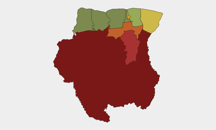
Interior districts Sipaliwini (risk 92), Brokopondo (risk 78), and Para (risk 74) drive the national risk profile, followed by the capital district Paramaribo (71). These regions face overlapping vulnerabilities: limited state presence and law-enforcement reach, informal mining and logging operations, transnational drug-trafficking corridors, and poorly maintained infrastructure in remote areas. Marowijne district (68) on the eastern border carries elevated risk due to cross-border criminal activity and informal settlement dynamics. Coastal and northwestern districts (Commewijne, Wanica, Saramacca) present significantly lower risk and support the majority of formal economic activity and resident expatriate populations.
How GeoBit Would Assist
Security teams with personnel or assets in Suriname should employ AOI Monitoring & Early Warning on high-risk districts (especially Sipaliwini, Brokopondo, Para) to detect emerging incidents—criminal activity, infrastructure failure, or civil unrest—before operational impact. Intel Sweep and multi-language OSINT fusion across local crime aggregators, police feeds, and regional news sources provide near-real-time situational awareness on routine but material threats (robbery, trafficking, vehicle accidents) affecting duty-of-care compliance. Routing & Network Analysis supports alternative journey planning for personnel and supply chains operating in interior regions, reducing exposure to high-risk transit corridors and infrastructure bottlenecks.
7-Day Outlook
No escalation in national-level security conditions is anticipated over the next week. Routine crime and infrastructure incidents will likely continue at baseline levels in interior and capital districts. Teams should maintain standard risk-mitigation protocols for movement in Sipaliwini, Brokopondo, and Para, and monitor local law-enforcement and weather-related disruptions affecting supply chains and personnel mobility.
GeoBit Analysis | Suriname | 2026-08-05
*Confidence: HIGH (verified absence of events; no conflicting signals)*
Highest-Risk Areas — Ranked
| # | State / Region | Risk |
|---|---|---|
| 1 | Sipaliwini | 92 |
| 2 | Brokopondo | 78 |
| 3 | Para | 74 |
| 4 | Paramaribo | 71 |
| 5 | Marowijne | 68 |
| 6 | Commewijne | 42 |
| 7 | Wanica | 38 |
| 8 | Saramacca | 29 |
| 9 | Coronie | 12 |
| 10 | Nickerie | 8 |
Sources
- geobit.ai
- surinamenieuwscentrale.com
- surinamenieuwscentrale.com
- shoeket.com
- surinamenieuwscentrale.com
- surinamenieuwscentrale.com
- drimble.nl
- surinamenieuwscentrale.com
- times.app.asrr.nl
- surinamesuntimes.com
- surinametimes.com
- newsdata.io
- surinametimes.com
- surinamenieuwscentrale.com
- whitehouse.gov
- seerist.com
- facebook.com
- nwitimes.com
Previous Daily Briefs
A new Suriname brief is written every day — each with its own risk map and downloadable CSV. Here's the last week; use the calendar to go further back.
📅 Browse every day by calendar →
Highlighted days have a brief. Tap a day for that day's map & analysis, or “csv” for that day's dataset ($5).
Atlas — our AI intelligence desk — emails them this snapshot personally. Nothing else, no list.