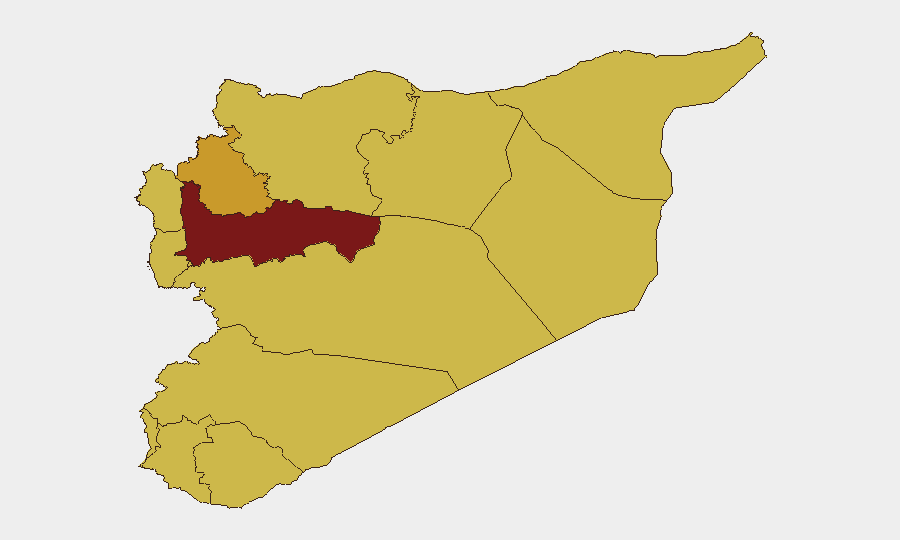
Situation Summary
Syria remains in a state of fragmented civil conflict with multiple concurrent drivers of instability: Israeli military incursions in the south, persistent ISIS attack capacity in the east-center, localized anti-government protests in southern governorates, and uncoordinated security-force attacks across Deir ez-Zor. The overall threat trajectory is one of chronic instability rather than rapid escalation, but with acute flash-point risks in border zones and ungoverned areas. Corporate assets and personnel face greatest exposure in Hama, Damascus, and the southern frontier zones.
Key Developments
- Southern Syria / Golan buffer zone (27–28 June): Israeli forces reported conducting cross-border tank operations inside Syria's declared security zone near Quneitra and Daraa, engaging armed individuals and killing multiple fighters. Syrian authorities have formally condemned the incursions as sovereignty violations. This represents the most significant external military action affecting Syrian territory in the last 48 hours and has elevated tension in the Quneitra–Daraa corridor.
- Quneitra governorate (28 June): Syrian state agency reports a recent spike in Israeli military positions (at least nine consolidating posts), home demolitions, civilian arrests, and checkpoint activity along the disengagement line, creating humanitarian access issues and compounding local instability.
- Deir ez-Zor countryside (26–28 June): Unidentified attackers have conducted repeated hit-and-run strikes and shootings against security personnel and checkpoints in an ongoing wave of incidents. This reflects persistent east-center instability independent of Israeli action.
- Raqqa city (26–27 June): ISIS operatives conducted a suicide attack on a security checkpoint, with one attacker detonating during engagement. The incident demonstrates continued ISIS operational capacity in urban centers, despite territorial losses.
- Southern governorates—Sweida and Daraa (28 June ongoing): Anti-government protests continue to be reported, driven by economic hardship and political grievances. While protests have largely subsided from their mid-June peak (13–17 June), underlying tensions remain and sporadic arrests and raids on ruling-party offices are ongoing.
Highest-Risk Areas
Hama Governorate (93.3 risk score) remains the single highest-risk jurisdiction, driven by overlapping civil-conflict dynamics and proximity to ungoverned territory. Damascus Governorate (79.4) presents capital-city volatility and concentrated security-force activity, with risk amplified by the concentration of international business and diplomatic presence. The southern frontier zone—particularly Quneitra (63.3), Daraa (63.3), and the UNDOF buffer area (63.3)—now presents acute Israeli–Syrian military tension and cross-border incursion risk, elevating short-term operational hazard for assets in that corridor. Idleb (72.5) and Aleppo (69.2) remain structurally unstable owing to historical conflict and proximity to Turkish border dynamics.
How GeoBit Would Assist
Security teams with personnel or assets in Syria should employ AOI Monitoring & Early Warning on high-risk governorates (especially Hama, Damascus, Quneitra, Daraa) to receive real-time alerts on military incidents, checkpoint changes, and protest activity. Conflict & Military tracking combined with OSINT fusion (Intel Sweep, multi-language Telegram/X monitoring, sentiment analysis) enables continuous assessment of Israeli–Syrian border dynamics and ISIS attack patterns in Deir ez-Zor and Raqqa. Routing & Network Analysis supports alternative journey planning and checkpoint avoidance for staff movement within and between high-risk zones.
7-Day Outlook
Israeli military activity in the southern security zone is likely to remain elevated, with additional incursion risk if border-area militants conduct attacks into Israel proper. Deir ez-Zor and Raqqa will continue to experience sporadic ISIS and ungoverned-actor violence, while southern anti-government protests may flare in response to economic conditions or security-force actions. Overall escalation to all-out regional conflict remains unlikely, but localized flash points will remain volatile.
Highest-Risk Areas — Ranked
| # | State / Region | Risk |
|---|---|---|
| 1 | Hama Governorate | 93.3 |
| 2 | Damascus Governorate | 79.4 |
| 3 | Idleb Governorate | 72.5 |
| 4 | Aleppo Governorate | 69.2 |
| 5 | Homs Governorate | 68.9 |
| 6 | Lattakia Governorate | 64 |
| 7 | Tartus Governorate | 63.3 |
| 8 | UNDOF | 63.3 |
| 9 | Al-Quneitra Governorate | 63.3 |
| 10 | Dar'a Governorate | 63.3 |
| 11 | Ar-Raqqa Governorate | 63.3 |
| 12 | Rif Dimashq Governorate | 63.3 |
Sources
Previous Daily Briefs
A new Syria brief is written every day — each with its own risk map and downloadable CSV. Here's the last week; use the calendar to go further back.
📅 Browse every day by calendar →
Highlighted days have a brief. Tap a day for that day's map & analysis, or “csv” for that day's dataset ($5).