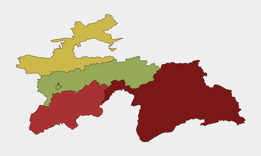
Situation Summary
Tajikistan remains a lower-tier global security concern (composite threat score 5), with no tracked discrete security events in the current assessment window. However, underlying vulnerabilities persist: the Gorno-Badakhshan Autonomous Region (GBAR) continues to present the country's most acute risks (score 92), driven by remote terrain, porous Afghanistan borders, and limited state reach. A recent destructive mudslide in GBAR and ongoing cross-border counter-narcotics operations underscore the fragility of infrastructure and border stability in high-altitude zones.
Key Developments
- Rushan District, Gorno-Badakhshan — 2026-07-22: President Rahmon ordered rapid recovery operations following a destructive mudslide that affected residents; this indicates active disaster-response pressure and infrastructure vulnerability in a remote, high-risk region.
- Tajikistan–Afghanistan Border (Regional) — 2026-07-20 to 2026-07-21: Media reporting indicates ongoing counter-narcotics and armed clashes between Tajik forces and suspected smugglers; framed as part of a sustained operational trend rather than a single dated incident, but reflects persistent border insecurity.
- Russia 201st Military Base, Tajikistan — 2026-07-20: Russian forces conducted anti-terrorism drills, signaling heightened military readiness posture; no civilian impact reported, but reflects regional security alignment.
- Dushanbe — 2026-07-22: President Rahmon concluded a state visit to Mongolia; a diplomatic engagement with no direct security implications but relevant to international positioning and travel patterns of senior leadership.
Note on evidence limits: Independent confirmation of discrete, last-48-hour incidents in the provided source set is limited. Border insecurity and counter-narcotics activity are confirmed as ongoing trends, but specific tactical incidents require second-source corroboration not yet available in this window.
Highest-Risk Areas
Gorno-Badakhshan (GBAR, risk 92) dominates the country's security profile due to its isolation, proximity to Afghanistan, weak state presence, and susceptibility to natural disasters and cross-border crime. Khatlon Region (risk 78) follows as a secondary concern, likely driven by drug-trafficking corridors and border permeability. Sughd Region (risk 65) presents moderate but material risk, while Dushanbe (risk 42) remains the most stable major urban center. These rankings reflect both the geography of the Afghanistan–Tajikistan border and the state's limited institutional capacity outside the capital and major transport corridors.
How GeoBit Would Assist
Organizations with personnel or assets in Tajikistan should employ AOI Monitoring & Early Warning to track Gorno-Badakhshan and border zones with persistent alerting on militant movement, smuggling activity, and natural hazards. Multi-language OSINT (Telegram, local news feeds, cross-border reporting) provides real-time visibility into informal intelligence networks and emerging incidents often unreported by international media. Routing & Network Analysis helps corporate teams plan alternative travel and supply routes away from highest-risk districts, while Conflict & Military tracking monitors Russian base operations and Tajik force posture that signal regional escalation risk.
7-Day Outlook
No sharp escalation is anticipated in the near term. However, summer weather patterns in GBAR may trigger additional mudslides or flooding, straining emergency response capacity. Border counter-narcotics operations are likely to continue; cross-border incidents may spike during July–August smuggling season. Duty-of-care teams should maintain heightened alerting on Gorno-Badakhshan and monitor diplomatic developments that could influence Taliban–Tajik relations.
Highest-Risk Areas — Ranked
| # | State / Region | Risk |
|---|---|---|
| 1 | Gorno-Badakhshan Autonomous Region | 92 |
| 2 | Khatlon Region | 78 |
| 3 | Sughd Region | 65 |
| 4 | Districts of Republican Subordination | 58 |
| 5 | Dushanbe | 42 |
Sources
Previous Daily Briefs
A new Tajikistan brief is written every day — each with its own risk map and downloadable CSV. Here's the last week; use the calendar to go further back.
📅 Browse every day by calendar →
Highlighted days have a brief. Tap a day for that day's map & analysis, or “csv” for that day's dataset ($5).
Atlas — our AI intelligence desk — emails them this snapshot personally. Nothing else, no list.