Situation Summary
Ukraine remains under sustained Russian conventional attack across multiple regions, with civilian casualties reported daily and air defenses facing repeated pressure from ballistic missiles and drone strikes. Political instability has emerged concurrently, following Prime Minister Yulia Svyrydenko's dismissal and parliamentary maneuvering over government formation, introducing uncertainty during a critical phase of military operations. The composite threat environment reflects both kinetic military risk and institutional strain, with Kyiv and central oblasts bearing the heaviest burden. Trajectory indicates continued high-intensity strikes on civilian and critical infrastructure targets, compounded by near-term governance transitions.
Key Developments
- Kyiv, 14 July 2026: Russian ballistic missile attack injured 12 civilians, demonstrating sustained penetration of air defenses around the capital despite ongoing interception efforts.
- Sumy city, Sumy Oblast, 13 July 2026: Russian bombing killed four civilians, including a 13-year-old girl, and wounded 17 others, marking one of the deadliest single incidents in the region in 24 hours.
- Zaporizhzhia city & 51 settlements, Zaporizhzhia Oblast, 13 July 2026: Coordinated Russian airstrikes across the region killed two civilians and injured approximately 59 across multiple strikes, signaling expanded targeting footprint.
- Donetsk Oblast (multiple settlements), 13 July 2026: Russian attacks across the region killed seven civilians and injured 21, consistent with sustained eastern-front pressure.
- Nationwide civilian toll, 13 July 2026: Ukrainian authorities reported at least 10 confirmed dead and approximately 80 injured across all regions in the preceding 24 hours from Russian strikes.
- Kyiv, political developments, 13 July 2026: Parliament prepared to vote on a new government following President Zelensky's removal of Prime Minister Svyrydenko; analysts warned the reshuffle risked institutional disruption during active conflict.
- Germany & France diplomatic statements, 14 July 2026: Both nations issued public statements on Ukraine, with Germany signaling disapproval of Kiev's government, reflecting broader diplomatic strain alongside military pressure.
Highest-Risk Areas
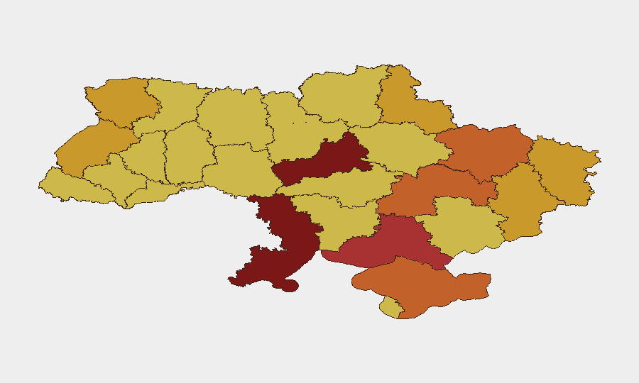
Kyiv remains the single highest-risk location (score 100), driven by exposure to ballistic and cruise missile strikes, high population density, and critical infrastructure concentration. Cherkasy Oblast (92.6) and Odesa Oblast (82.1) follow, reflecting Russian targeting of logistics, energy, and transportation networks in central and southern corridors. Kherson, Dnipropetrovsk, and Kharkiv oblasts (79.4–73.6) face compounded risk from proximity to active front lines, ongoing conventional forces engagement, and civilian population exposure. Risk elevation in central regions (Cherkasy, Kyiv) is being driven by Russia's shift toward deep strikes on rear-area civilian and administrative targets, while southern and eastern oblasts remain exposed to both conventional military operations and strikes on energy infrastructure.
How GeoBit Would Assist
Teams with staff or assets in Ukraine should deploy AOI Monitoring & Early Warning on high-risk oblasts (Kyiv, Cherkasy, Odesa) to receive real-time alerts on attack patterns and civilian casualty events. Battle Mapping, Force Structure, and Weapons-Capability Tracking enable security teams to anticipate strike corridors and assess air-defense effectiveness by sector. Conflict & Intelligence feeds, combined with Routing & Network Analysis, support dynamic duty-of-care decisions—identifying safe-passage windows, alternative transport routes, and shelter-in-place triggers as conditions shift hourly.
7-Day Outlook
Russian strike frequency and geographic dispersal are likely to sustain or increase over the next week, with ballistic missiles remaining the primary vector against Kyiv and rear areas. Political instability around government formation may delay or fragment coordination on civilian evacuation and resource allocation. Organizations with personnel in Kyiv, Cherkasy, Sumy, and Zaporizhzhia should maintain heightened alert posture and contingency protocols through at least 21 July pending stabilization of both military operations and governance structures.
Highest-Risk Areas — Ranked
| # | State / Region | Risk |
|---|---|---|
| 1 | Kyiv | 100 |
| 2 | Cherkasy Oblast | 92.6 |
| 3 | Odesa Oblast | 82.1 |
| 4 | Kherson Oblast | 79.4 |
| 5 | Autonomous Republic of Crimea | 74.8 |
| 6 | Dnipropetrovsk Oblast | 73.7 |
| 7 | Kharkiv Oblast | 73.6 |
| 8 | Sumy Oblast | 72.8 |
| 9 | Volyn Oblast | 72.6 |
| 10 | Donetsk Oblast | 72.3 |
| 11 | Lviv Oblast | 72.2 |
| 12 | Luhansk Oblast | 71.8 |
Sources
Previous Daily Briefs
A new Ukraine brief is written every day — each with its own risk map and downloadable CSV. Here's the last week; use the calendar to go further back.
📅 Browse every day by calendar →
Highlighted days have a brief. Tap a day for that day's map & analysis, or “csv” for that day's dataset ($5).
Atlas — our AI intelligence desk — emails them this snapshot personally. Nothing else, no list.