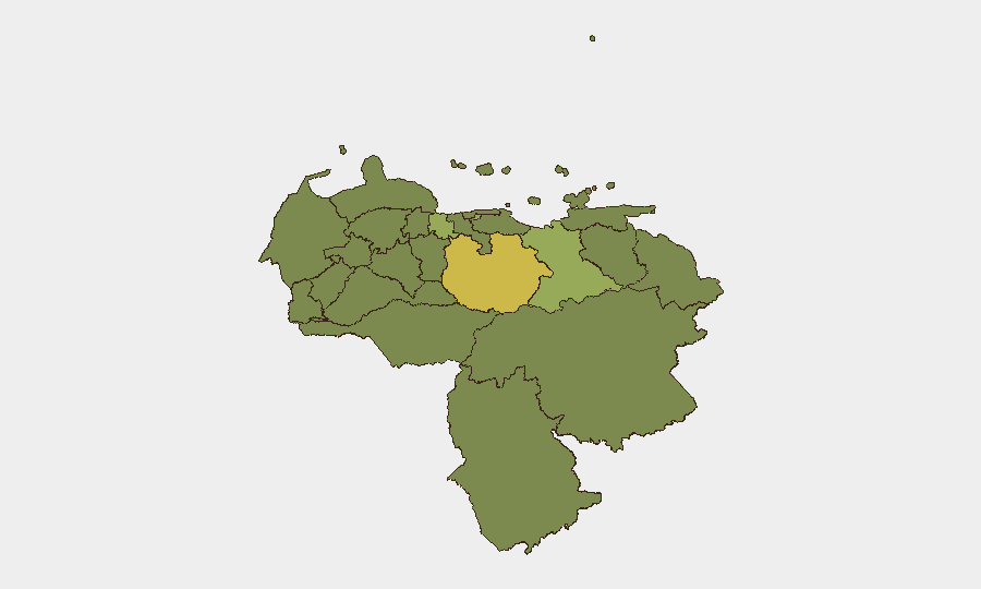
Situation Summary
Venezuela remains at composite threat rank #43 globally with a score of 49, reflecting ongoing instability across security, humanitarian, and governance domains. The country is in the immediate aftermath of major earthquakes (June 24), with nationwide emergency response still underway, widespread infrastructure damage, and power/communications outages persisting through early July. Event signals from the past 24–48 hours show elevated public dissent, arrest activity, and cross-sector friction (government–citizen, government–internal), suggesting stress on state capacity and legitimacy amid recovery operations. The security picture is volatile but not acutely deteriorating; however, post-disaster conditions typically amplify criminal and political risk.
Key Developments
- Caracas / nationwide (July 8, 2026): UN emergency coordinator requested an additional $296 million in life-saving aid for earthquake-affected populations, signaling ongoing humanitarian gaps and potential disruption to service delivery in vulnerable regions.
- Caracas / nationwide (July 4, 2026): State of Emergency remained in effect; U.S. Embassy reported widespread power and internet outages continuing to disrupt communications and emergency coordination across the country.
- Caracas—Simón Bolívar International Airport (July 4, 2026): Commercial flight operations were temporarily suspended due to earthquake damage; rail services were also cancelled, significantly restricting personnel and supply mobility.
- Government / internal (July 11, 2026): Event signals indicate arrest/detention activity and multiple instances of disapproval directed at government entities, consistent with post-crisis friction over response effectiveness and resource allocation.
- Border regions (July 4, 2026): U.S. Embassy reiterated elevated security risk in Colombia, Brazil, and Guyana border areas, citing ongoing crime, kidnapping risk, and limited emergency support—conditions likely exacerbated by earthquake-driven state capacity constraints.
Highest-Risk Areas
Guarico State (risk 63.9) ranks significantly above all other regions and warrants priority focus for organizations with operations there. The Federal District (54.2) and Carabobo State (43.3) follow, reflecting urban density, economic activity, and competing governance/criminal actors. Combined, these three regions account for elevated exposure to crime, civil disorder, and unpredictable state response during emergency operations. The remaining tracked states (Anzoategui, Vargas, Lara, Miranda, Apure, Falcon, Tachira, Zulia) cluster between 33.9 and 40.4, indicating sustained but more uniform baseline risk; border and rural zones (Apure, Tachira, border dependencies) carry additional exposure to trafficking, kidnapping, and informal armed activity. Post-earthquake conditions may further degrade state presence and service in lower-capacity regions.
How GeoBit Would Assist
Security teams should deploy AOI Monitoring & Early Warning (persistent watch on Guarico, Federal District, and Carabobo) to track arrest, protest, and infrastructure-failure events in real time. Intel Sweep and OSINT fusion (X/Twitter, Telegram, YouTube, radio SIGINT) provide 24-hour visibility into government messaging, civil unrest, and criminal activity signals across the country. For personnel movement and supply-chain resilience, Routing & Network Analysis identifies alternative transport corridors bypassing earthquake-damaged infrastructure and high-risk border zones. Satellite & Imagery analysis can assess recovery progress, security-force deployment, and informal settlement activity in high-risk states.
7-Day Outlook
Infrastructure repair will remain uneven; Caracas and major urban centers should see gradual restoration of power and flight operations, while remote and rural regions (Guarico, Apure, Tachira) face longer recovery timelines. Government credibility and internal cohesion will remain under strain; dissent signals may rise if aid delivery or basic services are perceived as inequitably distributed. Criminal opportunism (looting, kidnapping, trafficking) typically peaks in the 2–4 week window post-disaster; organizations with assets in Guarico and border zones should maintain heightened alertness through mid-July.
Highest-Risk Areas — Ranked
| # | State / Region | Risk |
|---|---|---|
| 1 | Guarico State | 63.9 |
| 2 | Federal District | 54.2 |
| 3 | Carabobo State | 43.3 |
| 4 | Anzoategui State | 40.4 |
| 5 | Vargas State | 36.8 |
| 6 | Lara State | 34.7 |
| 7 | Miranda State | 34.6 |
| 8 | Apure State | 34.5 |
| 9 | Falcon State | 34.2 |
| 10 | Tachira State | 34.2 |
| 11 | Zulia State | 33.9 |
| 12 | Federal Dependencies | 33.9 |
Sources
Previous Daily Briefs
A new Venezuela brief is written every day — each with its own risk map and downloadable CSV. Here's the last week; use the calendar to go further back.
📅 Browse every day by calendar →
Highlighted days have a brief. Tap a day for that day's map & analysis, or “csv” for that day's dataset ($5).
Atlas — our AI intelligence desk — emails them this snapshot personally. Nothing else, no list.