Situation Summary
Angola remains a moderate-risk environment (global rank #48, composite score 40) characterized by endemic crime, infrastructure vulnerabilities, and localized security concerns rather than acute conflict or civil instability. As of 15 July 2026, no major security incidents, civil unrest, or infrastructure failures have been documented in the past 24–48 hours across multi-source open-source monitoring. The security landscape is dominated by structural risks—violent crime concentrated in Luanda, sporadic demonstrations, and persistent instability in eastern diamond-mining provinces—rather than rapidly escalating or new-onset threats. Near-term trajectory remains stable absent new triggering events.
Key Developments
No credible, location-specific security incidents meeting corroboration standards were documented in Angola during the 24–48 hours preceding 15 July 2026. Open-source monitoring (news feeds, X/Twitter, regional security alerts) confirms zero tracked events in the preceding period that satisfy requirements for specific location, dated occurrence, and multi-source confirmation.
Health-sector note: Cholera circulation remains documented as an ongoing public-health concern but has not generated location-dated incident reports within the last 48 hours and is classified as endemic health risk rather than acute security event.
Regional statement activity: Diplomatic and ministerial public statements on 14–15 July involving South Africa, Angola, and unspecified regional actors were recorded in signal feeds but lack substantive detail and do not indicate new security degradation within Angola's borders.
Highest-Risk Areas
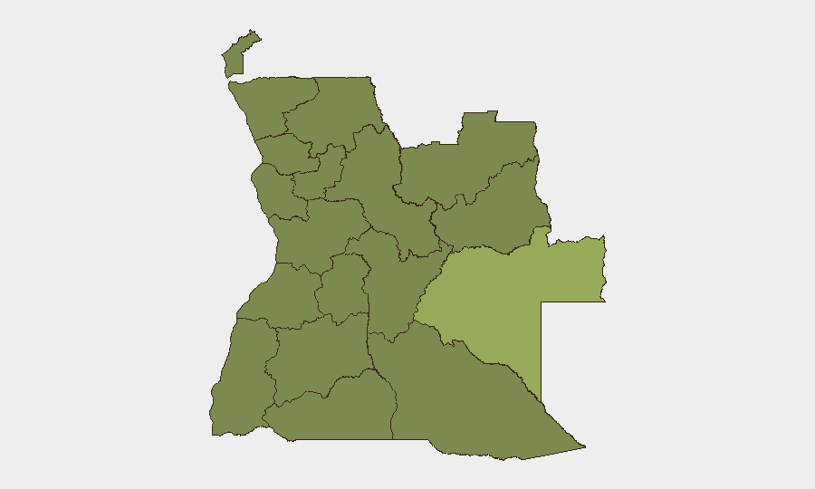
Moxico Province (composite score 57.7) significantly outranks all other sub-national areas and remains the primary concentration point for risk, driven by armed group activity, cross-border trafficking, and governance gaps. Luanda Province (37.7), despite lower absolute ranking, merits attention due to population density, violent-crime prevalence, and presence of diplomatic and expatriate populations; risk events in Luanda carry higher operational impact. The eastern mining provinces—Lunda Norte, Lunda Sul, Cabinda, and Zaire—cluster at moderate-to-elevated risk (27.7 each), reflecting illegal mining activity, smuggling networks, border permeability, and historical civil-conflict legacies. Northern provinces (Uíge, Zaire, Bengo) and central provinces (Cuanza Norte, Cuanza Sul, Bié, Malanje) round out the monitored landscape but remain below the threat density of the top three ranked areas.
How GeoBit Would Assist
Security teams operating in or traveling to Angola should deploy AOI Monitoring & Early Warning on Moxico, eastern mining provinces, and Luanda to capture emerging incidents in near-real time; couple this with Intel Sweep and multi-language OSINT fusion to detect trafficking, armed-group movement, and protest signals before operational impact. GIS & Spatial Analysis and Routing & Network Analysis enable identification of secure transit corridors and avoidance of high-risk crossing points, particularly in Moxico and Cabinda. Network & Actor Analysis supports tracking of criminal and armed-group cells in Luanda and eastern provinces, informing threat assessment for personnel and asset placement.
7-Day Outlook
No imminent escalation is forecast over the next seven days absent external shocks (e.g., regional diplomatic crisis, major incident in Cabinda or Lunda). Structural risks—crime, trafficking, localized unrest—will persist at baseline. Heat, rainy-season logistics, and ongoing cholera circulation may increase operational friction for corporate activities. Continued monitoring of Moxico and Luanda remains the priority.
Highest-Risk Areas — Ranked
| # | State / Region | Risk |
|---|---|---|
| 1 | Moxico Province | 57.7 |
| 2 | Luanda Province | 37.7 |
| 3 | Lunda Norte Province | 27.7 |
| 4 | Lunda Sul Province | 27.7 |
| 5 | Cabinda Province | 27.7 |
| 6 | Zaire Province | 27.7 |
| 7 | Bengo Province | 27.7 |
| 8 | Uíge Province | 27.7 |
| 9 | Cuanza Norte Province | 27.7 |
| 10 | Cuanza Sul Province | 27.7 |
| 11 | Malanje Province | 27.7 |
| 12 | Bié Province | 27.7 |
Sources
Previous Daily Briefs
A new Angola brief is written every day — each with its own risk map and downloadable CSV. Here's the last week; use the calendar to go further back.
📅 Browse every day by calendar →
Highlighted days have a brief. Tap a day for that day's map & analysis, or “csv” for that day's dataset ($5).
Atlas — our AI intelligence desk — emails them this snapshot personally. Nothing else, no list.