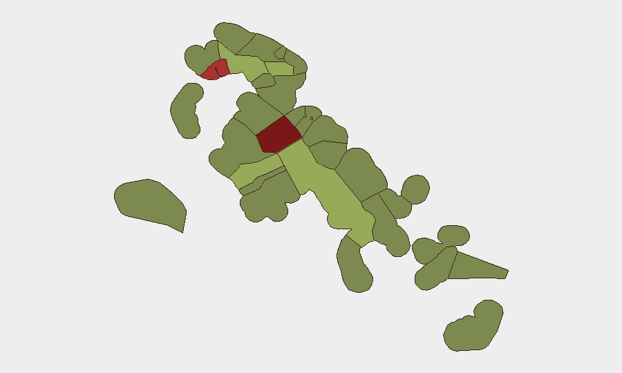
Situation Summary
The Bahamas remains at composite threat level 21 (global rank #77), with violent crime concentrated in urban centers but no discrete new security incidents reported in the last 24–48 hours. Baseline risk in Nassau (New Providence) and Freeport remains elevated following multiple fatal shootings in early August; U.S. travel advisory status is Level 2 ("Exercise Increased Caution"). The absence of newly reported incidents in mid-August does not signal de-escalation, but rather reflects a period without major documented events in monitored channels.
Key Developments
- No new confirmed security, crime, or civil unrest incidents detected in The Bahamas during 14–15 August 2026 across police releases, local news outlets, and open social media—baseline violent-crime exposure persists but no acute event spike is currently visible.
- New Providence (Nassau) – ongoing elevated violent-crime baseline. Earlier in August (2026-08-03, 2026-08-04, 2026-08-07), multiple fatal shootings and assaults occurred on West Bay Street and residential areas; no de-escalation signals have emerged, and crime remains concentrated in high-density urban areas and informal settlements south of Shirley Street.
- City of Freeport (Grand Bahama) – secondary violent-crime and unrest cluster. Freeport ranks second in sub-national risk (score 78); earlier August events included a lightning-triggered power-station explosion (2026-08-01) and associated civil unrest tied to government demolition operations in Blue Hills, creating secondary instability in an already crime-affected zone.
- Blue Hills demolition aftermath – localized civil unrest contained. Government demolition of 64 structures on 2026-08-01 triggered assault on task-force personnel and localized unrest; power restoration timeline remains unclear, but no escalation to wider protests has been reported as of mid-August.
- U.S. travel advisory unchanged – Level 2 status reinforced as of 11 August 2026. Advisory cites violent crime, armed robbery, burglary, and sexual assault as primary concerns, particularly in Nassau and Freeport; advisory status reflects structural risk rather than a single recent event.
Highest-Risk Areas
New Providence (risk 92) and City of Freeport (risk 78) drive the nation's threat profile, accounting for the vast majority of documented violent incidents and unrest. Central Abaco (risk 52) and Central Andros (risk 48) rank third and fourth, though with significantly lower event frequency; risk scores in outer islands likely reflect limited policing capacity, geographic isolation, and reported crime concentration rather than active unrest. Nassau's "Over the Hill" neighborhoods and Freeport's informal-settlement corridors are operational hotspots for armed robbery, gang activity, and homicide. Outer-island risks (Exuma, North Eleuthera, South Abaco) remain materially lower but should not be assumed safe without localized verification.
How GeoBit Would Assist
Security teams operating in The Bahamas would benefit from AOI Monitoring & Early Warning (persistent watch on Nassau, Freeport, and key outer-island nodes with alerting for new violent-crime or unrest events), Intel Sweep and multi-language OSINT (real-time monitoring of local police releases, Tribune 242, social media, and Telegram channels for emerging incidents), and Network & Actor Analysis (mapping of gang, smuggling, and organized-crime structures in Nassau and Freeport to anticipate localized violence spillover). Routing & Network Analysis enables duty-of-care teams to plan safer transit corridors away from documented hot zones.
7-Day Outlook
Violent crime in Nassau and Freeport is expected to remain at current elevated baseline; no precipitating event suggests imminent escalation or de-escalation. Continued monitoring of police communications, local media, and social channels is warranted to detect any clustering of incidents or civil unrest tied to government operations. Blue Hills power restoration and settlement of unrest from early-August demolitions will merit tracking for secondary destabilization.
Highest-Risk Areas — Ranked
| # | State / Region | Risk |
|---|---|---|
| 1 | New Providence | 92 |
| 2 | City of Freeport | 78 |
| 3 | Central Abaco | 52 |
| 4 | Central Andros | 48 |
| 5 | Exuma | 45 |
| 6 | East Grand Bahama | 42 |
| 7 | South Andros | 38 |
| 8 | North Abaco | 35 |
| 9 | North Eleuthera | 33 |
| 10 | South Abaco | 32 |
| 11 | Cat Island | 30 |
| 12 | Mangrove Cay | 28 |
Sources
Previous Daily Briefs
A new Bahamas brief is written every day — each with its own risk map and downloadable CSV. Here's the last week; use the calendar to go further back.
- August 13, 2026
- August 12, 2026
- August 11, 2026
- August 10, 2026
- August 9, 2026
- August 8, 2026
- August 7, 2026
📅 Browse every day by calendar →
Highlighted days have a brief. Tap a day for that day's map & analysis, or “csv” for that day's dataset ($5).
Atlas — our AI intelligence desk — emails them this snapshot personally. Nothing else, no list.