Situation Summary
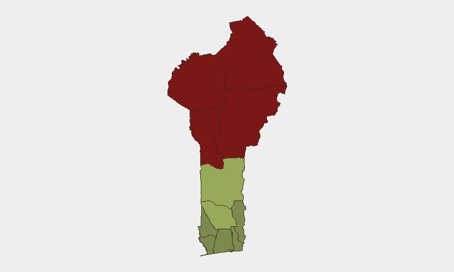
Benin remains stable nationally, with a composite threat score of 24 and no tracked major security events in the last 24–48 hours. Security risk is sharply concentrated in the north—particularly Alibori, Atakora, Donga, and Borgou departments—where terrorism, banditry, farmer–herder clashes, and smuggling networks pose persistent threats to personnel and asset mobility. Southern and central regions, including the capital and commercial hubs, maintain lower risk profiles but see routine urban crime and customs enforcement activity. The overall trajectory is one of managed but endemic northern instability, with no imminent nationwide escalation signals.
Key Developments
No clearly verifiable, Benin-specific security incidents with confirmed dates in the last 24–48 hours (July 30–31, 2026) are available from open-source reporting. The most recent timestamped event traceable to GeoBit signals is the July 29–30 window (drug-trafficking arrests in and near Benin City), which reflects routine law-enforcement activity rather than a shift in threat posture.
For operational awareness, the most recent *dated* development outside the 24–48-hour window is:
- July 22, 2026 · Anoum checkpoint (Atacora–Donga axis, northern Benin) – Customs intercepted a truck carrying approximately 500 kg of explosives destined for Malanville, underscoring active smuggling corridors and weapons-trafficking risk in the far north.
Undated but *recent* advisories (circulated by July 27, 2026) report reinforced military checkpoints and roadblocks near Natitingou (Atacora) and warn against travel within 50 km of the Burkina Faso, Niger, and Nigeria borders due to terrorism and banditry.
Highest-Risk Areas
The four northernmost departments—Alibori (92), Atakora (88), Donga (85), and Borgou (83)—drive Benin's overall risk profile. These areas face overlapping threats: transnational terrorism and militant spillover from Burkina Faso and Niger; organized banditry and smuggling networks (weapons, drugs, explosives); pastoral resource conflicts; and weak state presence in border zones. All are adjacent to the Sahel's active conflict corridor and sit astride major transnational trafficking routes. Risk drops sharply south of Zou Department (45), with coastal and central regions (Ouémé, Atlantique, Littoral) at low to moderate levels, reflecting denser state control and commercial infrastructure.
How GeoBit Would Assist
Security teams operating in Benin should employ AOI (Area-of-Interest) Monitoring & Early Warning on the four northern departments to detect emerging checkpoints, roadblocks, or militant activity. Routing & Network Analysis capabilities can identify and continuously update safe transit corridors and supply-chain alternatives, avoiding high-risk checkpoints and border zones. OSINT fusion—combining X/Twitter, Telegram, local media, and radio SIGINT—provides real-time sentiment and incident corroboration, particularly in the Atakora and Alibori zones where traditional reporting lags. For personnel operating in southern urban centers, entity extraction and network analysis of arrest/trafficking reports help identify organized crime nodes and their operating territories.
7-Day Outlook
No escalation in national security posture is anticipated over the next seven days; routine law enforcement and border smuggling interdictions will likely continue. Northern departments will remain under elevated watch for cross-border militant activity and banditry, particularly in the Natitingou region. Personnel and asset movements in the south should proceed under standard urban-crime precautions, with monitoring of checkpoint and roadblock reports along key northern transit routes.
Highest-Risk Areas — Ranked
| # | State / Region | Risk |
|---|---|---|
| 1 | Alibori Department | 92 |
| 2 | Atakora Department | 88 |
| 3 | Donga Department | 85 |
| 4 | Borgou Department | 83 |
| 5 | Zou Department | 45 |
| 6 | Collines Department | 42 |
| 7 | Plateau Department | 38 |
| 8 | Kouffo Department | 35 |
| 9 | Mono Department | 32 |
| 10 | Atlantique Department | 28 |
| 11 | Littoral | 25 |
| 12 | Ouémé Department | 22 |
Sources
Previous Daily Briefs
A new Benin brief is written every day — each with its own risk map and downloadable CSV. Here's the last week; use the calendar to go further back.
📅 Browse every day by calendar →
Highlighted days have a brief. Tap a day for that day's map & analysis, or “csv” for that day's dataset ($5).
Atlas — our AI intelligence desk — emails them this snapshot personally. Nothing else, no list.