Situation Summary
Botswana remains a low-threat environment by global standards (rank #156, composite score 7), with no discrete security events recorded in the current tracking window. No verified incidents of civil unrest, major crime, political instability, or infrastructure disruption have been reported in the last 24–48 hours from available sources. The security posture is stable, though sub-national risk concentration in urban and mining-dependent regions warrants continued monitoring of localized crime and economic pressures.
Key Developments
No verified security, civil-unrest, or major incident events have been identified in Botswana for 2026-09-02 to 2026-09-03 from available open-source reporting. Search results did not yield time-stamped, credible reports of new threats, protests, accidents, or infrastructure failures specific to Botswana in this period. Absence of reporting does not indicate absence of risk, but rather reflects current visibility constraints in real-time intelligence feeds.
Highest-Risk Areas
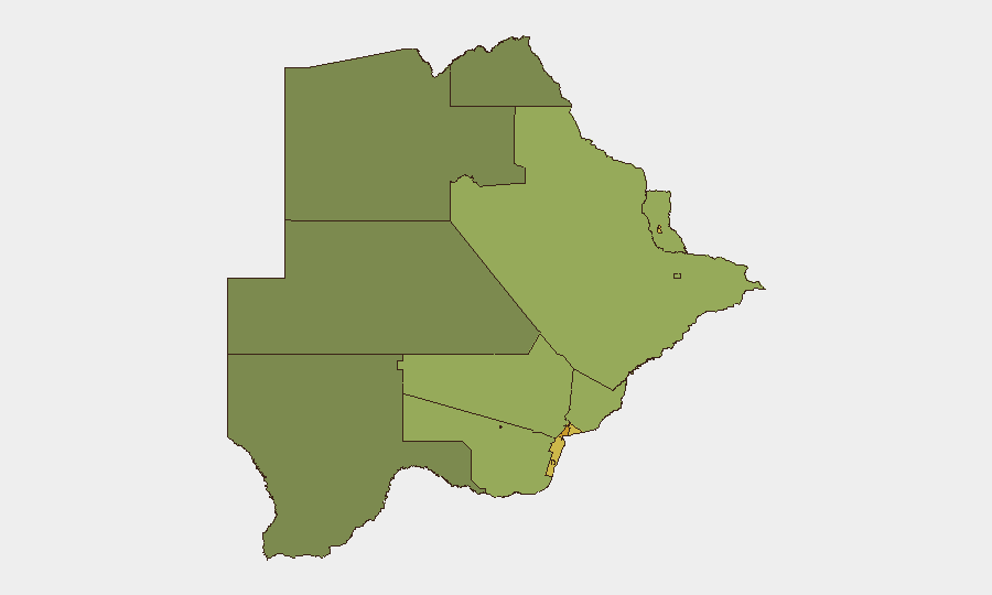
Urban and economically stressed regions drive sub-national risk concentration. Gaborone (risk 72) and South-East District (risk 68) carry the highest composite scores, reflecting density, transient populations, and typical urban crime patterns. Lobatse, Francistown, and mining centers (Jwaneng, Selebi Phikwe) register elevated risk (61–65), likely driven by economic volatility in extractive industries, informal settlement concentrations, and historical labor unrest. Remote northern and central districts (North-West, North-East, Central) show lower scores, consistent with lower population density and fewer organized crime vectors. Corporate assets and personnel should maintain heightened situational awareness in Gaborone and mining regions; secondary cities warrant standard due diligence.
How GeoBit Would Assist
Intel Sweep & OSINT Fusion would consolidate Botswana-specific reporting from news wires, social media (X/Twitter, Telegram), and regional African outlets to detect emerging incidents, protests, or supply-chain disruptions in real time. AOI Monitoring & Early Warning would establish persistent watches on high-risk zones (Gaborone CBD, Francistown, mining facilities, major highways) to alert teams to sudden unrest, protests, or security incidents before they escalate. Routing & Network Analysis and GIS & Spatial Analysis would support alternative journey planning for personnel and asset movements, especially during periods of elevated localized risk, helping teams avoid compromised corridors and optimize safety protocols.
7-Day Outlook
No imminent acute threat indicators are visible for the coming week. Routine crime and economic pressures in urban and mining regions are expected to remain the primary risk drivers; monitor local labor relations and fuel/power availability, as supply disruptions have historically triggered unrest. Recommended: cross-check official travel advisories, Botswana Police Service bulletins, and regional media daily, and report any credible local rumors (e.g., announced protests, transport strikes, or accidents) for rapid contextual risk assessment.
Report Date: 2026-09-03
Confidence Level: Medium (limited current-window reporting; baseline assessment reflects stable trend but does not preclude localized incidents outside current search visibility)
Highest-Risk Areas — Ranked
| # | State / Region | Risk |
|---|---|---|
| 1 | Gaborone | 72 |
| 2 | South-East District | 68 |
| 3 | Lobatse | 65 |
| 4 | Francistown | 62 |
| 5 | Jwaneng | 61 |
| 6 | Selebi Phikwe | 58 |
| 7 | Southern District | 55 |
| 8 | Kgatleng District | 50 |
| 9 | Kweneng District | 48 |
| 10 | North-East District | 45 |
| 11 | Central District | 42 |
| 12 | North-West District | 38 |
Sources
Previous Daily Briefs
A new Botswana brief is written every day — each with its own risk map and downloadable CSV. Here's the last week; use the calendar to go further back.
- August 31, 2026
- August 29, 2026
- August 26, 2026
- August 24, 2026
- August 22, 2026
- August 20, 2026
- August 18, 2026
📅 Browse every day by calendar →
Highlighted days have a brief. Tap a day for that day's map & analysis, or “csv” for that day's dataset ($5).
Atlas — our AI intelligence desk — emails them this snapshot personally. Nothing else, no list.