Situation Summary
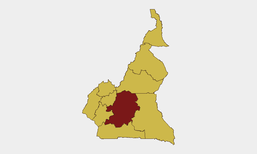
Cameroon remains at composite threat level #23 globally (score 92), with acute security pressure concentrated in the Far North region where Boko Haram cross-border incursions and military counter-operations continue to drive civilian casualties. Centre region shows the highest sub-national risk (94.5), though the most recent confirmed incidents cluster in Far North's Mayo-Tsanaga and Logone-et-Chari divisions. Recent signals include military mobilization, religious-institutional tension, and expatriate-directed hostility, indicating a multi-vector threat environment. The security posture remains volatile with limited near-term de-escalation indicators.
Key Developments
- Tourou, Mayo-Tsanaga, Far North — 14 July 2026: Cameroonian Rapid Intervention Battalion (BIR) forces killed two Boko Haram fighters during an operation following reports of cross-border militant movement from Nigeria.
- Tourou, Mayo-Tsanaga, Far North — 15 July 2026: A Boko Haram attack on an army outpost resulted in one civilian death, four soldier injuries, and serious wounding of an infant; operational tempo and civilian exposure remain high.
- Dabanga, Waza district, Logone-et-Chari, Far North — night of 16–17 July 2026: A suspected Boko Haram raid killed seven villagers and injured several others, confirming sustained militant presence in the division.
- Douala, Bonamoussadi — night of 11–12 July 2026: Structural collapse of a three-storey residential building during heavy rains killed at least six and injured six; indicates secondary hazard risk (infrastructure vulnerability) in major urban centers during precipitation events.
- National — 18 July 2026: GEOBIT event signal flagged disapproval sentiment between Protestant institutional actors and Cameroon authorities; underlying trigger and scale remain under clarification.
- National — 17 July 2026: GEOBIT event signal flagged rejection directed at expatriate communities; no corroborated incident report yet available; warrant continued monitoring for xenophobic escalation or specific targeting.
Highest-Risk Areas
Centre region dominates the risk ranking (94.5), likely reflecting proximity to Yaoundé and concentration of government, diplomatic, and commercial assets vulnerable to organized crime, civil unrest, or regime-stability incidents. The Far North (64.5), Northwest, Southwest, and Littoral regions follow at equivalent risk; Far North's ranking reflects verified Boko Haram operational presence and recurring cross-border violence, while Northwest and Southwest historically experience separatist tensions and resource competition. Littoral's inclusion (Douala) reflects urban crime, infrastructure fragility, and population density. The uniform scoring of eight regions at 64.5 suggests GeoBit's model is calibrating to sustained baseline instability across most of the country outside the capital corridor.
How GeoBit Would Assist
Security teams should activate AOI Monitoring & Early Warning on Far North divisions (Mayo-Tsanaga, Logone-et-Chari) to detect cross-border Boko Haram movement patterns and military counter-operations in near real-time. OSINT fusion and multi-language social/Telegram intelligence would clarify the Protestant-authority and expatriate-directed hostility signals before escalation. Conflict battle mapping and force-structure tracking would enable duty-of-care teams to map safe corridors and blackout zones for personnel and asset movement in Centre and Littoral regions.
7-Day Outlook
Far North security incidents are likely to persist at current frequency (2–3 confirmed events per week) given Boko Haram's established operational cycle and limited dry-season constraints. Littoral infrastructure vulnerability may spike again with forecasted precipitation. Watch for clarification of the religious-institutional and expatriate tensions—if linked to broader anti-government or anti-foreign mobilization, risk could escalate outside current threat scores within 5–7 days.
Highest-Risk Areas — Ranked
| # | State / Region | Risk |
|---|---|---|
| 1 | Centre | 94.5 |
| 2 | Northwest | 64.5 |
| 3 | Southwest | 64.5 |
| 4 | West | 64.5 |
| 5 | Littoral | 64.5 |
| 6 | Adamawa | 64.5 |
| 7 | South | 64.5 |
| 8 | Far-North | 64.5 |
| 9 | North | 64.5 |
| 10 | East | 64.5 |
Sources
Previous Daily Briefs
A new Cameroon brief is written every day — each with its own risk map and downloadable CSV. Here's the last week; use the calendar to go further back.
📅 Browse every day by calendar →
Highlighted days have a brief. Tap a day for that day's map & analysis, or “csv” for that day's dataset ($5).
Atlas — our AI intelligence desk — emails them this snapshot personally. Nothing else, no list.