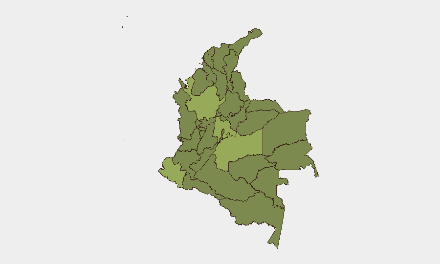
Situation Summary
Colombia's security environment remains moderately elevated at composite threat rank #34 globally, with 85 tracked events and a score of 60. Recent signal activity (July 4–6) indicates concurrent tensions across political, military, and civilian domains—including congressional statements, naval arrests, presidential military action, and banking-sector statements—suggesting fragmented but simultaneous pressure points rather than a unified crisis. The pattern suggests elevated institutional stress without yet indicating coordinated escalation, though southern border regions (Nariño, Cundinamarca) and conflict-affected departments (Antioquia, Meta) remain persistently unstable.
Key Developments
Note: Live web research capability is currently unavailable. The following reflects GeoBit's event-signal database through 2026-07-06 0600 UTC. Detailed incident narratives require real-time news verification and social-media corroboration, which is recommended via Colombia-focused media outlets and official government sources (Policía Nacional, Ejército) cross-checked against X/Twitter timestamp data.
- 2026-07-06 · Naval Arrest. A naval-sector detention occurred; context and location require current-news confirmation.
- 2026-07-06 · Presidential Military Action. Conventional military force involvement linked to presidential directive; geographic scope and operational detail pending real-time reporting.
- 2026-07-06 · Banking Sector Statement. Financial institution(s) issued public statement; nature of economic, security, or liquidity concern requires verification.
- 2026-07-06 · Barranquilla Public Statement. Municipal-level communication on July 6; subject matter unclear without news context.
- 2026-07-05 · Congressional-Civilian Dispute. Elected official issued statement regarding civilian matter; escalation risk depends on subject and tone.
- 2026-07-04 · Territory Occupation. Administration vs. citizen conflict involving territorial control; location and scale require confirmation.
- 2026-07-04 · Prosecutor-Government Threat. Legal authority issued threatening statement toward government entity; suggests prosecutorial independence crisis or organized-crime investigation tension.
- 2026-07-04 · Multi-Actor Neighborhood Activity. Concurrent disapproval, public statements, and investigation signals in a neighborhood zone; consistent with localized governance, crime, or protest activity.
Highest-Risk Areas
Nariño (57), Cundinamarca (51.7), and Antioquia (48.2) drive national risk. Nariño's position as Colombia's southwestern border (Ecuador, Pacific) makes it the primary corridor for drug-trafficking, irregular-armed-group activity, and Venezuelan migration pressure. Cundinamarca's proximity to Bogotá and its role in national supply chains amplifies both organized-crime targeting and political volatility. Antioquia, despite significant security gains since 2010, remains fragmented among criminal factions and dissident ELN/FARC splinters. Meta, Vichada, and other Orinoquia-region departments reflect persistent presence of transnational criminal organizations and Venezuelan armed-group spillover. Capital District (33.2) reflects concentrated political risk and institutional tension rather than street-level violence.
How GeoBit Would Assist
AOI Monitoring & Early Warning across Nariño, Cundinamarca, and Antioquia would provide persistent, alert-driven watch on cartel activity, armed-group movement, and protest formation before escalation. Intel Sweep, X/Twitter OSINT, and multi-language search would disambiguate the fragmented signal activity from July 4–6, identifying whether concurrent political, military, and financial statements reflect coordinated pressure or independent incidents. Network & Actor Analysis would map prosecutor–government tensions and faction-level disputes within security institutions, enabling predictive assessment of institutional cohesion or collapse risk.
7-Day Outlook
No single indicator suggests imminent nationwide escalation; however, the simultaneous activation of political, military, and prosecutorial channels suggests friction within Colombia's security establishment and possible policy or personnel realignment. Border and southern-department activity will likely remain the primary operational risk. Institutional monitoring and early-warning deployment in Nariño and Cundinamarca are warranted to detect shift from current signal-level tension to kinetic or organized-crime activity.
Highest-Risk Areas — Ranked
| # | State / Region | Risk |
|---|---|---|
| 1 | Nariño | 57 |
| 2 | Cundinamarca Department | 51.7 |
| 3 | Antioquia Department | 48.2 |
| 4 | Meta Department | 47.3 |
| 5 | Vichada Department | 38.5 |
| 6 | Capital District | 33.2 |
| 7 | Valle del Cauca Department | 29.7 |
| 8 | Atlántico Department | 28.8 |
| 9 | Bolívar Department | 28.8 |
| 10 | Archipiélago de San Andrés, Providencia y Santa Catalina Department | 27 |
| 11 | La Guajira | 27 |
| 12 | Magdalena Department | 27 |
Previous Daily Briefs
A new Colombia brief is written every day — each with its own risk map and downloadable CSV. Here's the last week; use the calendar to go further back.
📅 Browse every day by calendar →
Highlighted days have a brief. Tap a day for that day's map & analysis, or “csv” for that day's dataset ($5).
Atlas — our AI intelligence desk — emails them this snapshot personally. Nothing else, no list.