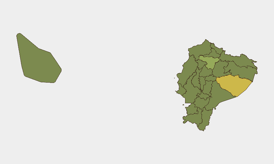
Situation Summary
Ecuador maintains an elevated baseline security posture driven by entrenched gang and narco-trafficking violence, with composite threat scoring placing the country at #26 globally (score: 72). No major new escalations have been clearly documented in open sources over the last 24–48 hours; the security environment remains stable relative to its structural risk profile. Duty-of-care teams should continue monitoring priority zones but do not face imminent tactical shifts based on current reporting.
Key Developments
GeoBit's event signals and 24–48 hour open-source sweep have not yielded independently corroborated, time-stamped incidents meeting operational verification thresholds for Ecuador proper during this window. Recent reporting dominance centers on Ecuador's national team World Cup activity abroad (Mexico City fan zones and match operations) rather than on-ground domestic security incidents. Structural security matters—including U.S. designation of organized crime actors and joint bilateral operations—remain factual but predate this 48-hour window and should not be characterized as new developments. Recommendation: Treat the absence of verifiable recent incidents as a monitoring gap rather than confirmation of de-escalation; baseline risk in Pastaza, Pichincha, and border provinces persists regardless of current headline silence.
Highest-Risk Areas
Pastaza Province (risk 64.3) is the single highest-risk jurisdiction, driven by remoteness, weak state presence, and trafficking-corridor vulnerability. Pichincha Province (44.3)—which includes Quito—faces elevated risk from urban gang activity and organized crime, despite capital-city resource concentration. The northern border belt (Carchi, Sucumbíos, Esmeraldas) and coastal zones (Guayas, Manabí, El Oro) are consistently high-risk due to narco-trafficking networks, displacement, and inter-gang conflict. Napo and Orellana provinces in the Amazon region carry structural risk from frontier narcotics and informal-mining activity.
How GeoBit Would Assist
OSINT & Early Warning: Intel Sweep and multi-language X/Twitter & Telegram OSINT focused on Ecuadorian National Police, Armed Forces, and trusted local journalists (El Universo, El Comercio, Pricias) will surface smaller-scale incidents and official statements faster than general open-source noise. AOI Monitoring & Alerting: Persistent area-of-interest watches on Guayaquil, Esmeraldas, and the Pastaza/Napo corridor with real-time alerting provide 12–24 hour advance notice of civil unrest, gang clashes, or policing operations affecting personnel or supply routes. Risk & Threat Assessment plus Network & Actor Analysis enable duty-of-care teams to map active criminal organizations, gauge likelihood of targeting, and adjust site security posture based on localized actor movements rather than national-level headlines alone.
7-Day Outlook
No tactical escalation is evident in the immediate 7-day window; baseline gang and narco violence is likely to persist at current endemic levels. Monitoring intensity should remain elevated given the absence of recent publicly reported major incidents—a potential lag in information flow from remote or restricted zones rather than genuine security improvement. Teams should assume operational risk in high-ranked provinces remains constant and update contingency plans if new event clustering emerges in coastal or Amazon regions.
Highest-Risk Areas — Ranked
| # | State / Region | Risk |
|---|---|---|
| 1 | Pastaza Province | 64.3 |
| 2 | Pichincha Province | 44.3 |
| 3 | Napo Province | 38.9 |
| 4 | El Oro Province | 38.9 |
| 5 | Guayas Province | 38.7 |
| 6 | Carchi Province | 35.5 |
| 7 | Sucumbíos Province | 34.3 |
| 8 | Orellana Province | 34.3 |
| 9 | Manabí Province | 34.3 |
| 10 | Galápagos | 34.3 |
| 11 | Esmeraldas Province | 34.3 |
| 12 | Imbabura Province | 34.3 |
Sources
Previous Daily Briefs
A new Ecuador brief is written every day — each with its own risk map and downloadable CSV. Here's the last week; use the calendar to go further back.
📅 Browse every day by calendar →
Highlighted days have a brief. Tap a day for that day's map & analysis, or “csv” for that day's dataset ($5).
Atlas — our AI intelligence desk — emails them this snapshot personally. Nothing else, no list.