Situation Summary
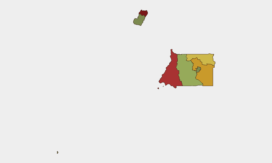
Equatorial Guinea remains a low-frequency, low-intensity security environment with a composite threat score of 5 and no tracked discrete events in the current reporting window. The country's overall stability is underpinned by limited civil unrest, low organized-crime reporting, and state capacity to contain localized incidents. However, sub-national variation is significant: northern and coastal provinces (Bioko Norte, Litoral, Wele-Nzas) carry substantially elevated risk relative to southern and island territories, driven by historical grievance dynamics, cross-border pressures, and population density.
Key Developments
No discrete security, crime, or infrastructure incidents meeting the criteria of "last 24–48 hours, verified, inside Equatorial Guinea" are confirmed in available open-source reporting. Web research captured extensive coverage of a third-country deportation arrangement whereby U.S. detainees have been transferred to a facility in Malabo (Bioko Norte) under agreement with the Equatorial Guinean government; however, the underlying transfers occurred around 21–22 August, with 24 August coverage representing follow-up reporting and commentary rather than a new on-the-ground incident. No additional unrest, breach, or disturbance at that facility is documented in the last 24–48 hours. Researchers are advised to monitor for any emerging incident signals in Malabo related to facility security, conditions, or detainee status.
Highest-Risk Areas
Bioko Norte (risk 85) and Litoral Province (risk 78) account for the majority of sub-national threat concentration. Bioko Norte, home to the capital Malabo and seat of government, carries elevated risk from historical secessionist sentiment, foreign-national density, and now the presence of third-country detainees under military or police oversight. Litoral Province (Bata area) reflects sustained cross-border vulnerabilities with Cameroon and traditional trafficking/smuggling corridors. Wele-Nzas Province (risk 72) bordering Gabon presents ongoing illicit-movement and small-arms proliferation pathways. In contrast, Annobón (risk 8) and Djibloho (risk 15) remain periphery zones with minimal active security reporting, reflecting geographic isolation and low population density.
How GeoBit Would Assist
Organizations with personnel or assets in high-risk provinces should deploy AOI Monitoring & Early Warning on Malabo, Bata, and cross-border entry points (Cameroon/Gabon frontier zones) to trigger alerts on protest activity, incident clustering, or facility disturbances. OSINT Fusion & Corroboration via X, Telegram, and regional Pan-African news wires will isolate genuine in-country incidents from diaspora commentary and international coverage. Network & Actor Analysis can map government, security-force, and detained-population dynamics to anticipate secondary cascades if facility conditions deteriorate or political pressure mounts.
7-Day Outlook
Absent new triggering events, Equatorial Guinea's threat posture is expected to remain stable and low-frequency. Continued monitoring of the Malabo detention facility and northern provincial activity is warranted, particularly if U.S. or international media attention sustains political pressure on the government. Cross-border commodity and human-movement activity (Cameroon, Gabon vectors) should remain on persistent watch; seasonal patterns and regional spillover from Central African conflicts remain secondary-order but latent risks.
Highest-Risk Areas — Ranked
| # | State / Region | Risk |
|---|---|---|
| 1 | Bioko Norte | 85 |
| 2 | Litoral Province | 78 |
| 3 | Wele-Nzas Province | 72 |
| 4 | Kié-Ntem Province | 68 |
| 5 | Centro Sur Province | 45 |
| 6 | Bioko Sur | 38 |
| 7 | Djibloho | 15 |
| 8 | Annobón Province | 8 |
Sources
Previous Daily Briefs
A new Equatorial Guinea brief is written every day — each with its own risk map and downloadable CSV. Here's the last week; use the calendar to go further back.
- August 22, 2026
- August 20, 2026
- August 18, 2026
- August 16, 2026
- August 14, 2026
- August 12, 2026
- August 10, 2026
📅 Browse every day by calendar →
Highlighted days have a brief. Tap a day for that day's map & analysis, or “csv” for that day's dataset ($5).
Atlas — our AI intelligence desk — emails them this snapshot personally. Nothing else, no list.