Situation Summary
Eritrea remains a low-threat environment overall (global rank #68, composite score 24), but border instability with Ethiopia and Sudan is intensifying amid renewed Ethiopia–TPLF conflict. Eritrean military assets and senior commanders have moved into northern Ethiopia's Tigray region over the past 5 days, marking a shift from containment to active cross-border deployment. The security picture reflects regional escalation rather than internal Eritrean instability, but the border triangle poses acute risk to personnel and operations in Gash-Barka and Southern Red Sea regions.
Key Developments
- Zalambessa, Ethiopia (Eritrean border) — *3 Aug 2026* — Senior Eritrean military commanders crossed into Ethiopia and entered Zalambessa in a public show of force bearing Eritrean insignia, signaling deliberate border-region positioning (Horn Review).
- Northern Tigray / Eritrean border — *6 Aug 2026* — Eritrean military assets including tanks and heavy weapons deployed into northern Ethiopia's Tigray region, coinciding with renewed Ethiopian–TPLF clashes (Horn Review).
- Shererina, Western Tigray — *1–3 Aug 2026* — Heavy fighting between Ethiopian army and TPLF forces near the Sudan–Eritrea–Ethiopia border triangle; clashes involved drones, artillery, and mechanized units; Tigrayan casualties and refugees fled into Sudan (Critical Threats, Al Jazeera).
- Eritrean–TPLF coordination claims — *7 Aug 2026* — Unverified social-media reports claim Tigrayan forces acquired drones "through Eritrea" and that Eritrean officials held meetings in Tigray; credibility unconfirmed pending independent corroboration.
- Border security environment deterioration — *1–6 Aug 2026* — Sustained surge in cross-border military movement and combat operations in the northern border zone; refugee flows into Sudan indicate pressure on civilian populations adjacent to Eritrean territory.
Highest-Risk Areas
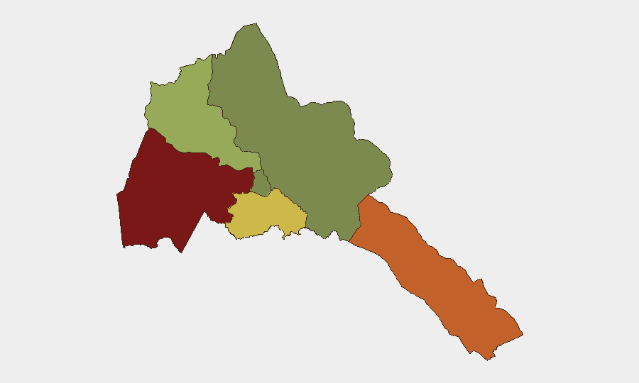
Gash-Barka (risk 92) and Southern Red Sea Region (risk 75) dominate the threat profile, driven by proximity to the Ethiopia–Sudan–Eritrea border triangle where renewed TPLF–Ethiopian army combat is occurring and Eritrean military assets are now actively deployed. Debub Region (risk 68) faces secondary risk from potential spillover; Maekel Region (Asmara, risk 18) and Northern Red Sea Region (risk 0) remain stable. The border escalation creates the primary threat vector—personnel and assets within 50 km of the western and southern borders should treat cross-border military activity, refugee movements, and potential logistical disruption as near-term hazards.
How GeoBit Would Assist
Teams should deploy AOI Monitoring & Early Warning on Gash-Barka and Southern Red Sea Region borders to track military movements, force concentrations, and refugee flows in real time. Battle Mapping and Conflict & Military Intelligence products will clarify Eritrean force positioning, coordination with Ethiopian actors, and likelihood of further cross-border operations. Satellite & Imagery Analysis on key border checkpoints and staging areas will provide early warning of troop surges or supply-line changes affecting duty-of-care obligations.
7-Day Outlook
Eritrean military involvement in the Ethiopia–TPLF conflict is likely to persist at current levels (deployment, coordination, border-area presence) unless a ceasefire is negotiated. Risk of direct Eritrean–Sudan friction or uncontrolled refugee influx into Eritrea's border regions remains moderate; internal Eritrean stability is not at risk. Corporate security teams should maintain heightened vigilance on border-region travel, supply chains, and staff safety protocols through at least 14 August pending further diplomatic signals.
Highest-Risk Areas — Ranked
| # | State / Region | Risk |
|---|---|---|
| 1 | Gash-Barka | 92 |
| 2 | Southern Red Sea Region | 75 |
| 3 | Debub Region | 68 |
| 4 | Anseba | 55 |
| 5 | Maekel Region | 18 |
| 6 | Northen Red Sea Region | 0 |
Sources
Previous Daily Briefs
A new Eritrea brief is written every day — each with its own risk map and downloadable CSV. Here's the last week; use the calendar to go further back.
📅 Browse every day by calendar →
Highlighted days have a brief. Tap a day for that day's map & analysis, or “csv” for that day's dataset ($5).
Atlas — our AI intelligence desk — emails them this snapshot personally. Nothing else, no list.