Situation Summary
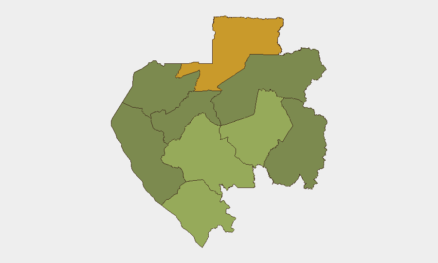
Gabon remains a low-threat environment with no confirmed security incidents, major civil unrest, or acute attacks reported in the past 24–48 hours. The country's composite threat score (3/100) reflects routine crime, underlying political tension, and structural fragility rather than active conflict or imminent escalation. The subnational risk map is concentrated in the northeastern and southeastern border regions (Woleu-Ntem and Ogooué-Lolo), while the capital and coastal zones remain substantially lower-risk. Current trajectory is stable with no indicators of near-term acute deterioration.
Key Developments
No discrete security, conflict, crime, or civil-unrest incidents with confirmed datelines of 5–6 August 2026 are available from Gabonese media or geolocated social-media sources.
Background (for context, not current development):
- 4 July 2026 – A military truck accident on the Franceville–Moanda road corridor (Haut-Ogooué) injured seven soldiers; this event falls outside the 24–48-hour window and does not represent a current development.
- July 2026 – Fatal road accidents reported on the Léconi–Souba axis and structural collapse at military construction site (Base aérienne 01, Libreville area) caused multiple fatalities; all dated to early July or June 2026.
- Ongoing – Military manoeuvres "Kalding 2026" are planned exercises in the Lambaréné area (Moyen-Ogooué) with no reported clashes or disruptions as of 6 August.
- Ongoing – Political tension persists between transitional leadership and opposition coalitions (National Republican Coalition), focused on energy contracts and governance rather than organized protest or blockades in the past two days.
Highest-Risk Areas
Woleu-Ntem Province (risk score 72) dominates the threat landscape, driven by remote geography, limited state capacity, border proximity to Cameroon and Equatorial Guinea, and historical trafficking routes. Ogooué-Lolo Province (58) presents secondary risk through similar border dynamics and sparse security infrastructure. These northeastern and southeastern zones account for the majority of Gabon's measurable subnational risk; by contrast, Estuaire Province (containing Libreville, score 15) and Ogooué-Ivindo (0) reflect stronger state presence and lower-crime profiles. Corporate assets in the capital and coastal oil-industry zones face significantly lower exposure than field operations or logistics hubs in the interior.
How GeoBit Would Assist
Security and duty-of-care teams should employ Intel Sweep and multi-language OSINT to track emerging political tension, cross-border movement, and cargo diversion in Woleu-Ntem and Ogooué-Lolo; AOI Monitoring & Early Warning to establish persistent watch on high-risk provincial capitals and transport corridors; and Routing & Network Analysis to identify safe transit alternatives for personnel and supply movement. Satellite & Imagery analysis can flag infrastructure damage, unauthorized gatherings, or military activity in remote zones where ground reporting is sparse. These tools together provide early detection of incidents before they scale and enable informed duty-of-care decisions for field teams.
7-Day Outlook
No acute escalation is anticipated in the 7-day horizon. Political positioning and energy-contract disputes will likely continue at the rhetorical level, and routine crime and road accidents remain the most probable security events. Border-region trafficking and smuggling activity should be assumed as constant background risk rather than triggered by specific events; monitoring of Cameroon-Gabon and Equatorial Guinea-Gabon crossing points remains a standard precaution for supply chains.
Highest-Risk Areas — Ranked
| # | State / Region | Risk |
|---|---|---|
| 1 | Woleu-Ntem | 72 |
| 2 | Ogooué-Lolo Province | 58 |
| 3 | Ngounié Province | 48 |
| 4 | Nyanga Province | 42 |
| 5 | Haut-Ogooué Province | 35 |
| 6 | Moyen-Ogooué Province | 28 |
| 7 | Ogooué-Maritime Province | 25 |
| 8 | Estuaire Province | 15 |
| 9 | Ogooué-Ivindo | 0 |
Sources
Previous Daily Briefs
A new Gabon brief is written every day — each with its own risk map and downloadable CSV. Here's the last week; use the calendar to go further back.
📅 Browse every day by calendar →
Highlighted days have a brief. Tap a day for that day's map & analysis, or “csv” for that day's dataset ($5).
Atlas — our AI intelligence desk — emails them this snapshot personally. Nothing else, no list.