Situation Summary
Iran remains at the highest composite threat level globally (score 100), driven by active military conflict and 923 tracked events in the past 30 days. The security environment has bifurcated: internal stability appears to be slowly recovering after weeks of violent demonstrations, with authorities reporting gradual internet restoration and reduced large-scale protests; simultaneously, maritime security in the Strait of Hormuz has sharply deteriorated, with confirmed drone attacks on commercial vessels, IRGC threats to restrict shipping corridors, and retaliatory U.S. strikes on Iranian radar and missile sites as of 26 June. The trajectory is unstable and multi-domain, with kinetic risk concentrated in southern maritime zones and residual civil-unrest risk in major urban centers.
Key Developments
- Strait of Hormuz – 26 June, 2026: U.S. officials reported Iran launched at least four drones at ships transiting the strait; U.S. forces responded with strikes on Iranian radar, missile, and drone sites, directly escalating military risk in the region's most critical shipping chokepoint.
- Cargo vessel attack – 26 June, 2026: At least one cargo ship was struck by a drone in or near the Strait of Hormuz; U.S. security sources attributed the attack to Iran, confirmed by UK Maritime Trade Operations, creating immediate insurance and supply-chain disruption risk.
- Hormuz shipping restriction threat – 26 June, 2026: Iranian Deputy Foreign Minister Kazem Gharibabadi and IRGC officials warned that safe passage through the Strait of Hormuz is possible "only via Tehran-approved routes," and that non-approved parallel corridors could be suspended, effectively threatening unilateral corridor closure.
- IMO evacuation pause – 26 June, 2026: The UN-linked initiative to evacuate shipping from the Strait of Hormuz was paused following a vessel attack; over 100 vessels have been evacuated in the past week, with oil flows disrupted and recovery incomplete.
- Internal internet restoration – 26 June, 2026: Iranian authorities announced "gradual" restoration of internet services following weeks of demonstrations; however, significant military presence remains visible on streets and connectivity disruptions persist in Tehran and other major cities.
- Congressional and diplomatic tensions – 25–26 June, 2026: Senate-executive, Iran-UK, and Iran-U.S. legislative investigations and disapproval statements signal sustained political friction driving state-level tensions alongside kinetic activity.
Highest-Risk Areas
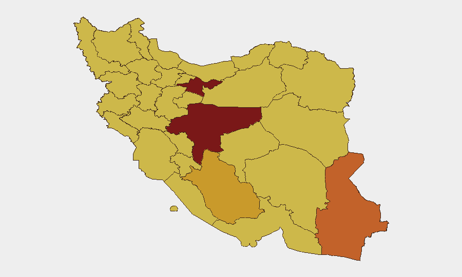
Tehran Province (risk 100) and Isfahan Province (risk 92.1) remain the focal points for civil unrest and government response, with visible military deployments and mourning gatherings. However, the most acute operational risk for international personnel and assets is now concentrated in southern maritime zones: Hormozgan Province (risk 70.2), Bushehr Province (risk 70.8), and Khuzestan Province (risk 70.2) face direct exposure to drone activity, naval interdiction, and shipping-route disruptions in and around the Strait of Hormuz. The elevation of maritime threat from tactical (sporadic incidents) to strategic (corridor restrictions and coordinated drone strikes) has inverted the risk profile in favor of coastal and maritime operations over inland cities.
How GeoBit Would Assist
Security teams should employ Maritime & Aviation tracking combined with AOI Monitoring & Early Warning to maintain persistent watch on Hormuz shipping lanes and Iranian naval/IRGC movements; Conflict & Military capabilities (force structure, radar and drone-site mapping, retaliatory-strike tracking) provide real-time battle mapping to anticipate further escalation. Routing & Network Analysis enables alternative-route and journey-planning tools for personnel and cargo avoidance of high-risk maritime corridors and coastal provinces, while Risk & Threat Assessment synthesizes multi-source feeds to flag corridor closures and new drone activity within operational timeframes.
7-Day Outlook
The Strait of Hormuz is likely to remain in a high-volatility, low-predictability state through early July, with further drone incidents, retaliatory strikes, or formal corridor restrictions plausible. Internal demonstrations appear to be stabilizing, but security-force presence and internet disruptions suggest authorities remain in containment posture. Any escalation in U.S.-Iran military exchanges or new restrictions on shipping will sharply elevate insurance, logistics, and personnel-movement risk for companies with assets or personnel in coastal provinces and major cities.
Highest-Risk Areas — Ranked
| # | State / Region | Risk |
|---|---|---|
| 1 | Tehran Province | 100 |
| 2 | Isfahan Province | 92.1 |
| 3 | Sistan and Baluchestan Province | 73.3 |
| 4 | Fars Province | 72.1 |
| 5 | Bushehr Province | 70.8 |
| 6 | Khuzestan Province | 70.2 |
| 7 | East Azerbaijan Province | 70.2 |
| 8 | Hormozgan Province | 70.2 |
| 9 | Semnan Province | 70.2 |
| 10 | Lorestan Province | 70.2 |
| 11 | Ilam Province | 70.1 |
| 12 | Kohgiluye and Buyer Ahmad Province | 70.1 |
Sources
Previous Daily Briefs
A new Iran brief is written every day — each with its own risk map and downloadable CSV. Here's the last week; use the calendar to go further back.
📅 Browse every day by calendar →
Highlighted days have a brief. Tap a day for that day's map & analysis, or “csv” for that day's dataset ($5).