Situation Summary
Israel remains at composite threat level 100 (rank #2 globally) driven by active conflict across multiple fronts: Gaza operations, West Bank security incidents, and escalating cross-border clashes with Hezbollah in Lebanon. Over the past 48 hours, fatalities have been reported in Gaza, Haifa, and the northern border zone, alongside civil-order incidents in Jerusalem. The trajectory shows intensifying military operations, extended emergency readiness in northern communities, and sustained risk of further cross-border escalation.
Key Developments
- Southern Lebanon / Northern Israel border (July 4, ~8h ago): IDF soldier injured in clash with gunman in southern Lebanon; IDF responded with shelling of Hezbollah positions, marking active cross-border military engagement.
- Northern Israel communities (July 4, starting 16:00): IDF announced extended defense times and emergency readiness across 49 communities near the Lebanon border, indicating heightened civil-defense posture.
- Haifa (July 4, ~8h ago): Second teenager killed in shooting incident in Haifa's northern area; severe violent-crime escalation in major urban center.
- Gaza Strip (July 3–4): At least seven Palestinians killed by Israeli forces during ongoing military operations over the 48-hour window.
- Jerusalem (July 4, ~4h ago): Ultra-Orthodox demonstrators harassed café patrons at Shabbat-open venue in central Jerusalem; police deployed to manage civil-order tension.
- Beit Ummar, West Bank (July 4): Security forces apprehended suspect following attempted ramming attack north of Hebron; thwarted terror incident.
Highest-Risk Areas
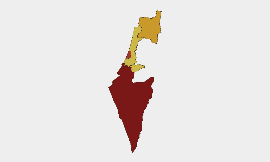
South District (risk 100) remains the primary driver due to active Gaza operations and sustained kinetic activity. Tel-Aviv District (77), North District (72.2), and Haifa District (70.8) are elevated by cross-border Hezbollah risk, northern community vulnerability, and violent-crime escalation respectively. Jerusalem and Center Districts (both 70) face compounded risk from civil-order tensions, security incidents, and population density. The northern border zone—particularly the 49 communities under extended defense alert—now represents the most acute near-term flashpoint for casualty risk.
How GeoBit Would Assist
Teams with personnel or assets across Israel should deploy AOI Monitoring & Early Warning on the South District, northern border communities, and urban centers (Haifa, Jerusalem, Tel Aviv) to receive real-time alert feeds on military activity, security incidents, and civil unrest. Conflict & Military battle mapping and force-structure tracking will provide situational clarity on IDF deployments and cross-border threat vectors, while Routing & Network Analysis enables alternative-route planning for personnel in or transiting high-risk zones. Intel Sweep and multi-language OSINT fusion on Telegram, X, and local Israeli feeds will surface emerging threats (civil unrest, protest activity, security incidents) 4–12 hours ahead of mainstream reporting.
7-Day Outlook
Sustained operations in Gaza and heightened Hezbollah activity in Lebanon are likely to persist, with northern Israel remaining under elevated civil-defense posture through at least July 10. Urban security incidents (shootings, civil-order clashes) are probable in Jerusalem, Haifa, and Tel Aviv. The risk of further cross-border military escalation between Israel and Hezbollah remains moderate-to-high; any significant IDF casualty or Hezbollah strike could trigger wider escalation within 24–48 hours.
Highest-Risk Areas — Ranked
| # | State / Region | Risk |
|---|---|---|
| 1 | South District | 100 |
| 2 | Tel-Aviv District | 77 |
| 3 | North District | 72.2 |
| 4 | Haifa District | 70.8 |
| 5 | Center District | 70 |
| 6 | Jerusalem District | 70 |
Previous Daily Briefs
A new Israel brief is written every day — each with its own risk map and downloadable CSV. Here's the last week; use the calendar to go further back.
📅 Browse every day by calendar →
Highlighted days have a brief. Tap a day for that day's map & analysis, or “csv” for that day's dataset ($5).
Atlas — our AI intelligence desk — emails them this snapshot personally. Nothing else, no list.