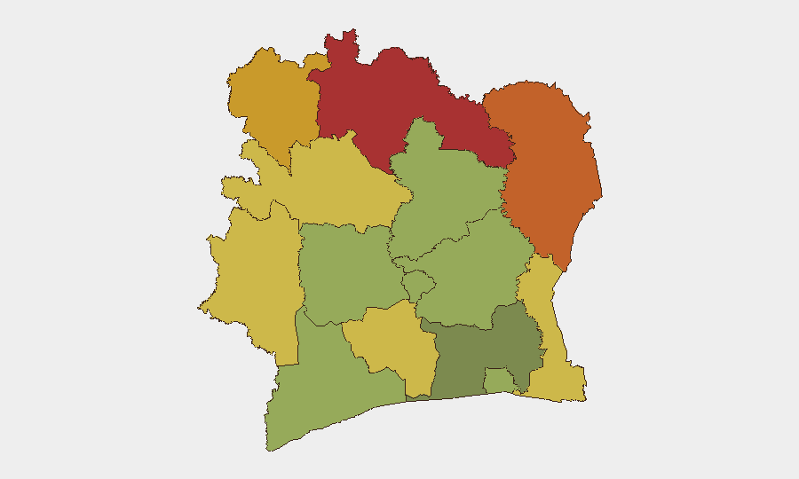
Situation Summary
Ivory Coast maintains a composite threat ranking of 15 globally (#65), with no corroborated security incidents, civil unrest, or acute travel disruptions reported in the last 24–48 hours. Open-source monitoring indicates relative stability, with recent reporting (23–24 July) from the Conseil national de sécurité describing the overall security situation as "globally stable," although officials have flagged persistent concerns around road safety, vehicle theft, and assassinations. Northern border regions (Savanes, Zanzan, Denguélé districts) remain elevated-risk zones due to transnational criminal and militant activity, but no new tactical incidents have emerged in the immediate reporting window.
Key Developments
- No new corroborated incidents (24–48h window). Open-source feeds, X/Twitter OSINT, and news monitoring show no discrete security, conflict, or crime events meeting current incident thresholds for Côte d'Ivoire in the last 48 hours.
- National security assessment (23–24 July, Abidjan). The CNS reported broad *decline* in home invasions, business robbery, and highway banditry, while maintaining alert for targeted assassinations and organized vehicle theft. This assessment reflects multi-sector security force operations and suggests stabilization in some crime categories, though persistent baseline risks remain.
- Road safety enforcement directive (23–24 July, nationwide axes). Following recent fatal traffic accidents on the Niakara–Katiola and Touba–Biankouma corridors, the President ordered stricter vehicle technical inspections and traffic-rule enforcement, signaling official concern about defective vehicles and driver non-compliance as acute hazards on major interurban routes.
- Homicide investigation closure noted (referenced 22 July, Abidjan-Cocody). Authorities confirmed arrest of suspects in the 5–6 July murder of a Yango delivery worker, framing the incident as isolated rather than indicative of broader security deterioration. Case resolution within days underscores functioning police investigation capacity.
- No mass-rally incidents reported. Political reporting notes the ruling RHDP suspended expensive presidential rallies to ease internal party tensions; no unrest, clashes, or public disturbance associated with political activity has been reported in the last 48 hours.
Highest-Risk Areas
The northern districts of Savanes (78), Zanzan (75), and Denguélé (72) dominate the sub-national risk profile, driven by persistent cross-border militant and criminal movement from Mali and Burkina Faso, artisanal mining activity, and limited state enforcement presence. Comoé and Montagnes districts (70, 68) continue to register elevated risk from similar transnational organized crime and security-force capability constraints. Abidjan itself (risk 45) remains below the national mean, reflecting functional law enforcement and urban resilience, though localized violent crime remains a concern for corporate personnel and assets in high-density commercial zones.
How GeoBit Would Assist
Corporate security teams should deploy persistent Area-of-Interest monitoring on the northern districts (Savanes, Zanzan, Denguélé) with alerting thresholds for cross-border militant or trafficking activity, paired with multi-language OSINT fusion of Malian and Burkinabe sources to anticipate spillover. Routing & network analysis for Abidjan-based personnel can identify lower-risk corridors and real-time route alternatives, especially given current emphasis on road-safety enforcement. Entity extraction and actor-network mapping will track criminal and militant networks operating in high-risk zones, supporting duty-of-care risk assessments.
7-Day Outlook
Barring new transnational incidents from the Sahel, stability is forecast to persist. Road-safety operations and ongoing enforcement actions should reduce accident-related incidents on key routes. Northern border risk remains structural and baseline-elevated; no tactical escalation is currently signaled.
Highest-Risk Areas — Ranked
| # | State / Region | Risk |
|---|---|---|
| 1 | Savanes District | 78 |
| 2 | Zanzan District | 75 |
| 3 | Denguélé District | 72 |
| 4 | Comoé District | 70 |
| 5 | Montagnes District | 68 |
| 6 | Woroba District | 65 |
| 7 | Gôh-Djiboua District | 60 |
| 8 | Sassandra-Marahoué District | 58 |
| 9 | Vallée du Bandama District | 55 |
| 10 | Bas-Sassandra District | 52 |
| 11 | Lacs District | 48 |
| 12 | Abidjan | 45 |
Sources
Previous Daily Briefs
A new Ivory Coast brief is written every day — each with its own risk map and downloadable CSV. Here's the last week; use the calendar to go further back.
📅 Browse every day by calendar →
Highlighted days have a brief. Tap a day for that day's map & analysis, or “csv” for that day's dataset ($5).
Atlas — our AI intelligence desk — emails them this snapshot personally. Nothing else, no list.