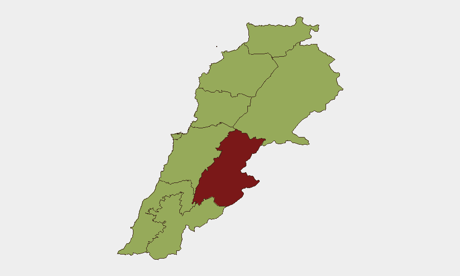
Situation Summary
Lebanon remains in an active conflict state (Global Threat Rank #19, Composite Score 81) with military operations, cross-border tensions, and internal instability dominating the security landscape. The Beqaa Governorate carries the highest sub-national risk (86.6), reflecting its proximity to Syria and role in regional military activity, while Beirut and multiple border zones maintain elevated threat profiles. Recent signal traffic indicates escalating diplomatic friction, military posturing, and internal security concerns, with no near-term de-escalation pathway evident.
Key Developments
- 2026-07-02 · US–Lebanon Relations Deterioration: Confirmed reduction in US diplomatic posture toward Lebanon; specific triggering incident requires field corroboration but signals widening international isolation.
- 2026-07-01 · Internal Physical Assault Incident: Lebanon-internal violent incident recorded; location and actor details insufficient from available signals; suggests heightened communal or political tension.
- 2026-07-01 · Iranian Threat Communication: Tehran escalated threatening language toward Lebanon, likely related to Hezbollah-linked governance or military alignment; timing aligns with broader regional messaging.
- 2026-06-30 · Israeli Military Operations Continue: Israeli forces confirmed ongoing presence in southern Lebanon security zone with stated intent to remain until Hezbollah threat subsides; represents sustained occupation posture rather than discrete tactical event.
- 2026-06-30 · Lebanese Government Threat Toward Iran: Lebanese state issued counter-threat messaging toward Tehran, suggesting internal factions leveraging external tensions for domestic political leverage.
- 2026-06-29 · Iranian Demand on Lebanon: Tehran issued formal demand toward Lebanese government; content unclear from signals but consistent with Iranian pressure on Hezbollah-aligned governance structures.
Note: Web research did not yield independently corroborated events time-stamped within the last 24–48 hours beyond the above signal detections. Late-June reporting (29–30 June) of 200+ Israeli airstrikes in southern Lebanon and civilian displacement exists but falls outside the strict 48-hour window for this brief.
Highest-Risk Areas
The Beqaa Governorate dominates risk (86.6) due to its role as a military operations zone, proximity to Syria, and concentration of non-state armed actors. Beirut (58.1) follows, driven by political volatility, diplomatic incidents, and infrastructure vulnerability. The South Governorate, North Governorate, and Akkar remain critically elevated (56.6 each) due to cross-border military activity, Israeli operations, and Syrian refugee/militant presence. These zones should be treated as no-go or high-control areas for all non-essential corporate presence; movement in and out of Beirut airport remains subject to sporadic closures and air-threat warnings.
How GeoBit Would Assist
Security teams should deploy AOI Monitoring & Early Warning on Beqaa, South Beirut, and airport corridors to detect military activity and closure signals in real time. Conflict & Military capability (battle mapping, force structure) and Network & Actor Analysis will clarify which armed groups control specific zones and their operational tempo. Routing & Network Analysis combined with Maritime & Aviation tracking supports duty-of-care teams in planning safe personnel movement, identifying alternative routes, and timing evacuations if escalation accelerates.
7-Day Outlook
Diplomatic friction (US–Lebanon, Iran–Lebanon, Lebanese counter-threats) suggests heightened political instability and potential for internal security incidents. Israeli military presence in the south and drone/missile threat signals from multiple actors indicate sustained operational intensity with low threshold for accidental escalation. Beirut airport functionality and cross-border security corridor stability should be monitored hourly; corporate personnel should assume restricted movement and prepare contingency evacuation protocols.
Highest-Risk Areas — Ranked
| # | State / Region | Risk |
|---|---|---|
| 1 | Beqaa Governorate | 86.6 |
| 2 | Beirut Governorate | 58.1 |
| 3 | North Governorate | 56.6 |
| 4 | Akkar Governorate | 56.6 |
| 5 | Keserwan-Jbeil Governorate | 56.6 |
| 6 | Mount Lebanon Governorate | 56.6 |
| 7 | South Governorate | 56.6 |
| 8 | Nabatieh Governorate | 56.6 |
| 9 | Baalbek-Hermel Governorate | 56.6 |
Sources
Previous Daily Briefs
A new Lebanon brief is written every day — each with its own risk map and downloadable CSV. Here's the last week; use the calendar to go further back.
📅 Browse every day by calendar →
Highlighted days have a brief. Tap a day for that day's map & analysis, or “csv” for that day's dataset ($5).