Situation Summary
Libya remains a fragmented, medium-threat environment (global rank #23, composite score 67) with persistent governance fragmentation, migrant exploitation, and localized militant activity. The most recent event signals (19–20 July) indicate tension between government actors, civilian populations, and external parties—including a Greece–Libya diplomatic friction point and internal investigative activity involving business entities. The security picture is driven less by acute national crisis than by chronic sub-national instability concentrated in southern and eastern regions.
Key Developments
- 2026-07-20 · Government–Business Friction: An investigation opened between Libyan business and government entities; details remain limited, but reflects ongoing institutional tension and potential sanctions-evasion or corruption concerns.
- 2026-07-20 · Diplomatic Friction: Public statement from Greek government signaling reduced relations with Libya—likely tied to maritime boundary or migration-flow disputes; escalation risk remains low but warrants monitoring of shipping and energy infrastructure near territorial boundaries.
- 2026-07-20 · National Threat Statement: Government issued a public threat assessment or warning affecting Libya broadly; context unclear from available signals, but may reflect border security, migrant smuggling, or internal security concern.
- 2026-07-19 · Presidential Statement vs. Civilian Community: Presidential or senior leadership public statement directed at civilian population; tone and substance unknown, but suggests either reassurance messaging or warning of policy changes.
- 2026-07-19 · Migrant-Related Investigation: Law enforcement or judicial body opened investigation related to migrant populations—consistent with ongoing trafficking, forced labor, and exploitation prevalent in Libya's detention system and labor markets.
- 2026-07-19 · Libyan Actor Threat: Non-state or opposition actor issued threat statement; severity and target unspecified, but reflects persistent factional or militant posturing.
Note: Available open-source corroboration for the past 24–48 hours is limited. The signals above reflect GeoBit's event-classification stream; independent verification through news, Telegram, or social-media OSINT is recommended for operational decision-making.
Highest-Risk Areas
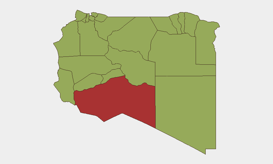
Murzuq (risk 77) and the southern Fezzan remain Libya's most volatile region, driven by weak state capacity, ISIS-affiliate activity, and intra-militia conflict over smuggling routes and oil infrastructure. Derna (risk 58.2) in the northeast continues to harbor militant cells and suffer from militia fragmentation; Jabal al Akhdar and Sirte (both 50.7) present persistent terrorism and intra-LNA friction risks. The cluster of western and southern districts (Az Zawiya, Nalut, Wadi al Shatii, Kufra, Nuqat al Khams—all risk 47) reflects chronic criminality, human-trafficking networks, and weak border controls. These twelve areas account for the majority of Libya's tracked security events; travel, asset placement, and supply chains in or through these zones demand elevated vetting and contingency planning.
How GeoBit Would Assist
Security teams operating in Libya should employ AOI Monitoring & Early Warning on high-risk sub-national zones (Murzuq, Derna, Sirte) to detect tactical escalation before it affects operations. Multi-language OSINT fusion (X, Telegram, Arabic media) coupled with entity extraction and network analysis will clarify the identities, intent, and reach of the government–business and migrant-related investigations announced on 19–20 July. Battle mapping and force-structure tracking in the south, combined with satellite imagery analysis, will maintain visibility on LNA and militia positioning near critical infrastructure.
7-Day Outlook
Expect continued institutional friction between Tripoli and eastern/southern power centers, with migrant policy and international maritime boundaries as near-term friction points. No imminent national-level crisis is signaled, but localized militia clashes in Murzuq, Derna, and Fezzan are routine; travel risk in those zones will remain elevated. Diplomatic engagement with Greece and potential new sanctions or business restrictions warrant close monitoring.
Highest-Risk Areas — Ranked
| # | State / Region | Risk |
|---|---|---|
| 1 | Murzuq | 77 |
| 2 | Derna | 58.2 |
| 3 | Jabal al Akhdar | 50.7 |
| 4 | Sirte | 50.7 |
| 5 | Nalut | 47 |
| 6 | Ghat | 47 |
| 7 | Baladiyah Surman | 47 |
| 8 | Az Zawiya District | 47 |
| 9 | Wadi al Shatii | 47 |
| 10 | Wadi al Hayaa | 47 |
| 11 | Kufra | 47 |
| 12 | Nuqat al Khams | 47 |
Sources
Previous Daily Briefs
A new Libya brief is written every day — each with its own risk map and downloadable CSV. Here's the last week; use the calendar to go further back.
📅 Browse every day by calendar →
Highlighted days have a brief. Tap a day for that day's map & analysis, or “csv” for that day's dataset ($5).
Atlas — our AI intelligence desk — emails them this snapshot personally. Nothing else, no list.