Situation Summary
Mali remains Africa's highest-conflict environment, ranking #14 globally with a composite threat score of 78 across 43 tracked incidents. The past 48 hours have seen no independently verified armed clashes, tactical attacks, or infrastructure damage; however, underlying political and security tensions persist across the northern and central regions. Bamako faces elevated scrutiny following unconfirmed aerial-weapons signals detected near the capital on 23 June, though verification remains pending. The threat trajectory remains volatile, driven by junta instability, press-freedom repression, and fragmented armed-group activity in the Sahel corridor.
Key Developments
- Bamako, 23 June 2026 – Unconfirmed aerial-weapons signals detected near the capital; no independent verification of origin, intent, or impact as of 27 June.
- Countrywide, 25 June 2026 – No independently verified armed clashes, arrests, or infrastructure damage confirmed in the 48-hour period ending 25 June, suggesting a tactical lull rather than de-escalation.
- Bamako/National, 26–27 June 2026 – Multiple event signals flagged involving arrest/detention, threats, and public statements linked to Somalia-related diplomatic or criminal cases; specific Mali-internal incidents not yet independently confirmed.
- Press Freedom, June 2026 – Ongoing reports of journalist arrests and suspension of radio programs; pattern consistent with junta press-control measures but no single dated incident isolated for the last 24 hours.
- Threat Environment (Background context since April) – JNIM and Azawad Liberation Front attacks in late April tested junta response capacity; no major escalation confirmed since late May, though group positioning remains active.
Highest-Risk Areas
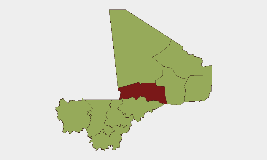
Timbuktu (84.5) and Bamako (72.5) drive Mali's sub-national risk profile. Timbuktu's elevated score reflects persistent armed-group presence, trafficking networks, and limited state control in the northern Sahel; Bamako's 72.5 rank indicates capital-level political fragility, intelligence/security operations, and the concentration of diplomatic and corporate assets. Eight additional regions—Ménaka, Kayes, Taoudénit, Kidal, Gao, Koulikoro, Ségou, Sikasso, and Mopti—cluster at 54.5, signaling widespread low-to-moderate armed-group activity and banditry across the center and north. Organizations with personnel or assets in Bamako should prioritize duty-of-care protocols around political volatility and surveillance; those in the north (Timbuktu, Gao, Kidal) should assume persistent AQIM/JNIM/FLM presence and apply movement restrictions accordingly.
How GeoBit Would Assist
Intel Sweep and OSINT Fusion enable real-time aggregation of X, Telegram, and news-wire reporting to isolate verified incidents from rumor within hours of occurrence—critical for distinguishing tactical threat from background noise in Mali's noise-heavy information environment. AOI Monitoring & Early Warning provides persistent watch over Bamako, Timbuktu, and key transport corridors, with automated alerting on force movements, checkpoints, or armed clashes before they affect operations. Battle Mapping and Force-Structure Tracking help security teams understand group positioning (JNIM, FLM, RSF proxies, junta units) and predict high-risk zones for personnel movement or asset exposure.
7-Day Outlook
No major escalation is anticipated in the next seven days, though the absence of confirmed incidents in the last 48 hours likely reflects operational pause rather than resolved tension. Expect continued press-control measures and periodic diplomatic friction over Somalia-related cases. Personnel and asset movements should remain contingent on real-time AOI monitoring and incident corroboration; risk appetite in Timbuktu and northern border zones should remain minimal pending independent verification of stability improvement.
Highest-Risk Areas — Ranked
| # | State / Region | Risk |
|---|---|---|
| 1 | Timbuktu | 84.5 |
| 2 | Bamako | 72.5 |
| 3 | Ménaka | 54.5 |
| 4 | Kayes | 54.5 |
| 5 | Taoudénit Region | 54.5 |
| 6 | Kidal | 54.5 |
| 7 | Gao | 54.5 |
| 8 | Koulikoro | 54.5 |
| 9 | Ségou Region | 54.5 |
| 10 | Sikasso Region | 54.5 |
| 11 | Mopti | 54.5 |
Sources
Previous Daily Briefs
A new Mali brief is written every day — each with its own risk map and downloadable CSV. Here's the last week; use the calendar to go further back.
📅 Browse every day by calendar →
Highlighted days have a brief. Tap a day for that day's map & analysis, or “csv” for that day's dataset ($5).