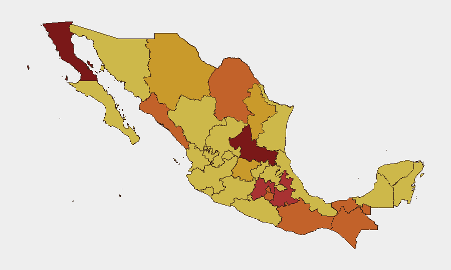
Situation Summary
Mexico remains at acute risk (rank #5 globally, composite score 100) driven primarily by active conflict between cartels and state forces across multiple regions. The security environment has deteriorated along key supply corridors and in territorial strongholds, with 512 tracked events in the current reporting cycle. Recent presidential and official statements, coupled with military operations in high-profile zones, indicate sustained government pressure on organized crime but ongoing operational capability by criminal organizations.
Key Developments
- Military operations reported in Mazatlán (Sinaloa), 2026-07-07: Conventional military force deployment noted; details on engagement scale and outcome pending corroboration.
- Territorial occupation by migrant populations, 2026-07-06: Reports of migrant groups occupying spaces in unspecified locations; authorities investigating; implications for supply chains and border control under assessment.
- Corporate asset occupation, 2026-07-05: Companies reported experiencing territorial occupation or blockade; Secretariat-level investigation initiated, suggesting federal-level concern.
- Community-versus-corporation armed engagement, 2026-07-05: Conventional military force incident reported; geographic specificity and casualty/damage data not yet confirmed via secondary sources.
- Official statements and investigations, 2026-07-05 to 2026-07-06: Multiple statements by Mexican authorities and presidential office; Secretariat and law enforcement agencies conducting parallel investigations into recent incidents, signaling coordination but potential fragmentation of response.
- Firefighter service disruption, 2026-07-06: Reports of disapproval or action against firefighter operations; unclear if labor-related, security-related, or response-capacity degradation; warrants monitoring.
*Note: Detailed timestamps, casualty figures, and named cartels/units require cross-reference with official Mexican government advisories and regional media to confirm.*
Highest-Risk Areas
San Luis Potosí (risk 100), Baja California (84.8), and Puebla (77.2) dominate the ranking, reflecting convergence of cartel supply-route control, border volatility, and state institutional weakness. State of Mexico and Mexico City (76.7 and 74.5 respectively)—both proximity to the capital—indicate that violence and organized crime penetrate the national power center's geography. Sinaloa, Morelos, and Oaxaca cluster at 74.1, historically rooted in narcotics trafficking, migration facilitation, and territorial disputes between regional cartels. The consistency of scores across this cohort (71–84) suggests systemic fragmentation of state monopoly on violence rather than isolated incidents.
How GeoBit Would Assist
AOI Monitoring & Early Warning would establish persistent watch on San Luis Potosí, Baja California, and key municipalities in Sinaloa and State of Mexico, generating alerts on military/police deployments, road blockades, and territorial changes. Intel Sweep and OSINT fusion—including X/Twitter, local news, and Secretariat bulletins—would corroborate incidents within 24 hours, enabling duty-of-care teams to validate whether specific facilities, routes, or personnel are in active impact zones. Battle mapping and conflict tracking would decompose territorial control, cartel operations, and state operations by municipality, allowing security teams to distinguish high-risk from moderate-risk neighborhoods within the same state.
7-Day Outlook
Federal security operations in Sinaloa and neighboring states are likely to intensify in the near term, with secondary effects on border crossings, logistics, and migrant movement. Territorial occupation of corporate assets and migrant encroachments suggest either spillover from cartel territorial disputes or resource scarcity driving organized movements; further incidents are probable unless rapid de-escalation occurs. The next 48–72 hours will be critical to establish whether current military operations represent a tactical surge or sustained campaign shift.
Highest-Risk Areas — Ranked
| # | State / Region | Risk |
|---|---|---|
| 1 | San Luis Potosí | 100 |
| 2 | Baja California | 84.8 |
| 3 | Puebla | 77.2 |
| 4 | State of Mexico | 76.7 |
| 5 | Mexico City | 74.5 |
| 6 | Chiapas | 74.5 |
| 7 | Sinaloa | 74.1 |
| 8 | Morelos | 74.1 |
| 9 | Oaxaca | 74.1 |
| 10 | Tabasco | 74.1 |
| 11 | Coahuila | 73.8 |
| 12 | Guanajuato | 72.8 |
Sources
Previous Daily Briefs
A new Mexico brief is written every day — each with its own risk map and downloadable CSV. Here's the last week; use the calendar to go further back.
📅 Browse every day by calendar →
Highlighted days have a brief. Tap a day for that day's map & analysis, or “csv” for that day's dataset ($5).
Atlas — our AI intelligence desk — emails them this snapshot personally. Nothing else, no list.