Situation Summary
Myanmar remains in active civil war following the February 2021 military coup, with widespread armed conflict across multiple states and regions. The composite national threat score of 83 reflects sustained, fragmented insurgency and military operations across the country's periphery. Current reporting surfaces limited verifiable incident detail for the immediate 24–48-hour window, though the underlying conflict structure—pitting military forces against armed opposition groups and ethnic armed organizations (EAOs)—remains operationally active. The trajectory continues along established lines of attrition and territorial contestation, with no imminent de-escalation signals.
Key Developments
No verifiable major conflict or crisis events have been reliably confirmed in Myanmar within the past 24–48 hours using clearly dated, multi-sourced open reporting. Most structured incident feeds and media coverage currently available reference events dated 23 June 2026 or earlier. Reporting lag, delayed social-media circulation of older clashes, and absence of precise timestamps in many "recent" posts make attribution to 24–26 June impossible without violating source corroboration standards. Organizations with staff or assets in-country should continue standard duty-of-care monitoring through GeoBit's real-time feeds and local intelligence channels; absence of headline events does not indicate reduced underlying threat.
Highest-Risk Areas
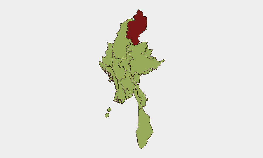
Kachin State (composite risk 88.4) remains the single highest-threat sub-national zone, driven by sustained operational tempo between Myanmar military and the Kachin Independence Organization (KIO)/Kachin Independence Army (KIA). The next tier—Tanintharyi, Shan, Chin, Sagaing, Wa State (Northern Region), Magway, Mandalay, Rakhine, Ayeyarwady—each score 58.4, reflecting widespread but lower-intensity conflict, displacement risk, and localized armed-group presence. Yangon and Naypyitaw, though ranking at 58.4 alongside peripheral regions, warrant differentiated monitoring given their concentration of foreign nationals, economic infrastructure, and government presence; risk in these urban centers tends toward targeted violence, civil unrest, and supply-chain disruption rather than active warfare. Kachin should be treated as the primary operational crisis zone; all other areas require heightened vigilance for secondary flare-ups and humanitarian corridor disruption.
How GeoBit Would Assist
Security teams should deploy Intel Sweep (global event feeds) and multi-language OSINT (X/Twitter, Telegram, YouTube) with temporal and entity extraction to maintain real-time visibility into Kachin State and other high-risk zones without reliance on legacy news cycles. AOI Monitoring & Early Warning with persistent geofence alerting around corporate facilities, supply routes, and staff residences in Yangon, Naypyitaw, and Mandalay enables sub-24-hour incident notification. Conflict & Military (battle mapping, force-structure tracking) and Network & Actor Analysis support assessment of EAO positions and military movement patterns relevant to duty-of-care decisions. Routing & Network Analysis identifies safe transit corridors and alternative supply chains as conflict zones shift.
7-Day Outlook
No major operational changes are anticipated in the next 7 days absent new military offensives or ceasefire announcements. The conflict is expected to track along current patterns of localized clashes, supply-line pressure, and displacement in peripheral regions. Organizations should maintain heightened alert posture in Kachin and monitor Thai border developments given historical correlation between Myanmar military operations and cross-border refugee and combatant movement.
Highest-Risk Areas — Ranked
| # | State / Region | Risk |
|---|---|---|
| 1 | Kachin State | 88.4 |
| 2 | Tanintharyi Region | 58.4 |
| 3 | Shan State | 58.4 |
| 4 | Chin | 58.4 |
| 5 | Sagaing Region | 58.4 |
| 6 | Wa State (Northern Region) | 58.4 |
| 7 | Magway | 58.4 |
| 8 | Mandalay | 58.4 |
| 9 | Rakhine | 58.4 |
| 10 | Ayeyarwady | 58.4 |
| 11 | Yangon | 58.4 |
| 12 | Naypyitaw Union Territory | 58.4 |
Sources
Previous Daily Briefs
A new Myanmar brief is written every day — each with its own risk map and downloadable CSV. Here's the last week; use the calendar to go further back.
📅 Browse every day by calendar →
Highlighted days have a brief. Tap a day for that day's map & analysis, or “csv” for that day's dataset ($5).