Situation Summary
Niger's composite threat ranking (99/100, #12 globally) reflects persistent militant activity and political tension across multiple regions, particularly in the northwest and along the Nigerian and Burkina Faso borders. Live web research conducted over the last 24–48 hours has not surfaced reliably documented new security incidents within Niger itself; recent reporting focuses on Nigeria or pre-dates the current assessment window. The underlying threat landscape—driven by Islamic State Sahel Province (ISSP) and Jama'at Nusrat al-Islam wal-Muslimin (JNIM) operations, as characterized in mid-June reporting—remains materially unchanged.
Key Developments
No new security incidents in Niger have been reliably documented in the last 24–48 hours. Recent event signals in the GeoBit feed reference Nigeria, student unrest, and investor/government disputes; none are geographically or substantively tied to current Niger security developments.
Background context (mid-June, outside the current window):
- 17 June 2026 – ISSP mounted large-scale attacks on Inates and Banibangou in Tillabéri Region, resulting in military and civilian casualties.
- 18 June 2026 – JNIM conducted an attack on Diori Hamani International Airport, Niamey, the capital.
These incidents underscore the operational tempo of transnational militant groups but are not current developments. No reliable reporting of follow-on strikes, arrests, or policy responses has emerged in the 24–48-hour window preceding this brief.
Highest-Risk Areas
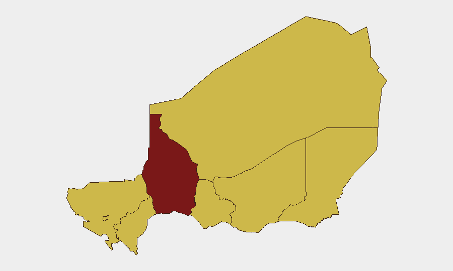
Tahoua Region (risk score 99.2) is the primary driver of Niger's national threat ranking, significantly outpacing all other administrative divisions. The remaining seven regions—Agadez, Zinder, Diffa, Tillabéri, Niamey, Dosso, and Maradi—are assessed at parity (69.2 each), indicating a broad geographic distribution of risk. Tillabéri's inclusion in this group reflects documented ISSP activity (mid-June attacks); Diffa and Agadez are historically vulnerable to cross-border Boko Haram and ISSP incursions from Nigeria and Chad. Niamey's inclusion signals political and security tensions in the capital, though recent incidents there predate the current assessment window. The western regions (Dosso, Maradi) and southern zones (Zinder) face lower but meaningful militant and criminal activity spillover.
How GeoBit Would Assist
Corporate security and duty-of-care teams would employ AOI Monitoring & Early Warning on Tahoua, Tillabéri, and Niamey to detect renewed militant activity and political unrest in real time. OSINT Fusion & Corroboration (X, Telegram, local media, and radio SIGINT) provides tactical awareness of attack preparation and government response; Conflict & Military battle mapping and force-structure tracking clarify militant disposition and operational capability. Routing & Network Analysis supports alternative journey planning for personnel transiting high-risk zones.
7-Day Outlook
No imminent shift in threat posture is indicated by available reporting. ISSP and JNIM retain demonstrated capacity and intent to conduct attacks in Tillabéri, Agadez, and around Niamey; seasonal and operational cycles may drive renewed strikes within 7–14 days. Political tensions referenced in event signals warrant monitoring for disruptions affecting airport and border operations, though current reporting does not indicate an immediate security escalation.
Highest-Risk Areas — Ranked
| # | State / Region | Risk |
|---|---|---|
| 1 | Tahoua Region | 99.2 |
| 2 | Agadez Region | 69.2 |
| 3 | Zinder Region | 69.2 |
| 4 | Diffa Region | 69.2 |
| 5 | Tillabéri Region | 69.2 |
| 6 | Niamey | 69.2 |
| 7 | Dosso Region | 69.2 |
| 8 | Maradi Region | 69.2 |
Sources
Previous Daily Briefs
A new Niger brief is written every day — each with its own risk map and downloadable CSV. Here's the last week; use the calendar to go further back.
📅 Browse every day by calendar →
Highlighted days have a brief. Tap a day for that day's map & analysis, or “csv” for that day's dataset ($5).