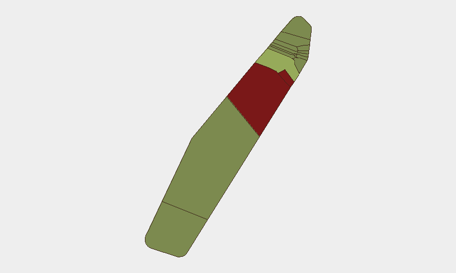
Situation Summary
Palau maintains a stable security environment with no verified incidents, civil unrest, crime spikes, infrastructure disruptions, or travel-risk developments reported in the last 24–48 hours. The nation ranks #189 globally on GeoBit's composite threat index (score: 2), reflecting a low baseline risk profile. No discrete security events are currently tracked, and routine monitoring across all inhabited states shows no active threats to personnel or assets.
Key Developments
- No confirmed incidents nationwide — 4–6 August 2026 — Monitoring sources reported zero verified security, civil unrest, crime, infrastructure, or travel-risk developments across Palau during the reporting window.
- No infrastructure disruptions in Koror — 4–5 August 2026 — Power, ports, airports, telecoms, and water/sewage systems operational; no new outages detected.
- No incidents in Peleliu (highest sub-national risk area) — 4–5 August 2026 — Despite elevated baseline risk, no fresh security events reported.
- No incidents in Angaur (second-highest risk area) — 4–5 August 2026 — No new developments in this historically higher-risk state.
- Routine regional security cooperation ongoing — 4–6 August 2026 — Palau participating in scheduled regional preparation activities with security partners; not responsive to active incidents.
Highest-Risk Areas
Peleliu (risk score 92) and Angaur (risk score 88) carry substantially elevated sub-national risk profiles, though neither has reported active incidents in the current window. The risk elevation in these two states reflects historical patterns—both are less developed, remotely located, and experience sporadic infrastructure and governance challenges rather than acute security threats. Koror (risk score 45), as the economic and population center, carries moderate risk primarily linked to port operations, tourism density, and maritime activity. All other inhabited states score below 35, indicating low residual concern; the nation-wide absence of current events suggests these baselines are not acutely elevated.
How GeoBit Would Assist
For corporate security and duty-of-care teams with personnel or assets in Palau, GeoBit's AOI Monitoring & Early Warning capability would provide persistent, real-time alerting on Peleliu and Angaur to flag emerging incidents before wider impact. Infrastructure & Utility Scanning (via Shodan and sensor integration) offers continuous verification of port, airport, telecom, and power status in Koror and other economic hubs. Multi-language OSINT and social-media intelligence (X, Telegram, local news feeds) enable early detection of civil unrest, crime, or political instability before formal reporting, critical in a Pacific island environment with limited mainstream media presence.
7-Day Outlook
No indicators suggest imminent escalation of security concerns in Palau over the next seven days. The nation's political calendar, maritime activity, and infrastructure remain stable. Routine monitoring should continue with heightened sensitivity to Peleliu and Angaur; any personnel movement to those states warrants pre-deployment risk review and liaison with local authorities.
Highest-Risk Areas — Ranked
| # | State / Region | Risk |
|---|---|---|
| 1 | Peleliu | 92 |
| 2 | Angaur | 88 |
| 3 | Koror | 45 |
| 4 | Melekeok | 35 |
| 5 | Airai | 32 |
| 6 | Ngatpang | 28 |
| 7 | Ngeremlengui | 26 |
| 8 | Ngaraard | 25 |
| 9 | Ngardmau | 24 |
| 10 | Aimeliik | 23 |
| 11 | Ngiwal | 22 |
| 12 | Ngchesar | 21 |
Sources
Previous Daily Briefs
A new Palau brief is written every day — each with its own risk map and downloadable CSV. Here's the last week; use the calendar to go further back.
📅 Browse every day by calendar →
Highlighted days have a brief. Tap a day for that day's map & analysis, or “csv” for that day's dataset ($5).
Atlas — our AI intelligence desk — emails them this snapshot personally. Nothing else, no list.