Situation Summary
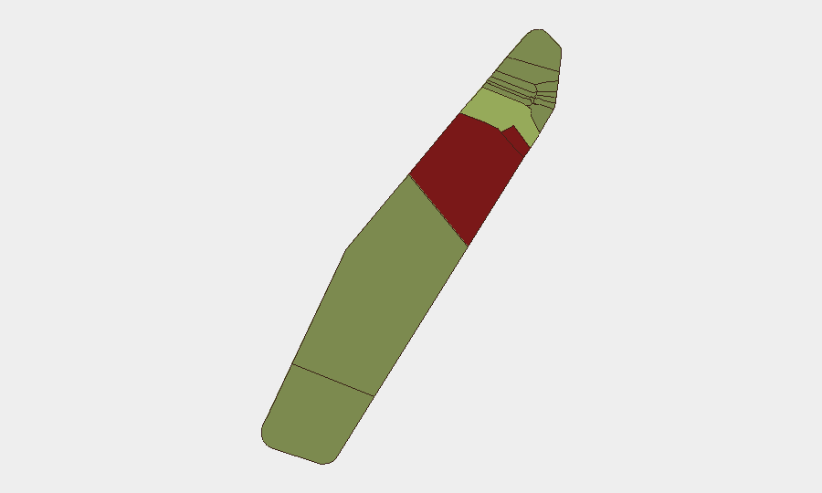
Palau remains a low-threat environment with no verified security incidents, civil unrest, crime spikes, or infrastructure disruptions reported in the last 24–48 hours. The nation ranks #189 globally on composite threat scoring, reflecting stable conditions across most of its island states. Baseline risk concentration in Peleliu and Angaur persists, but no active triggering events have been detected in the current reporting window.
Key Developments
- Nationwide, Palau (2026-08-04 to 2026-08-06): Multi-source monitoring across security, civil unrest, crime, and infrastructure channels confirmed no verified incidents or disruptions during the 24–48-hour window.
- Koror, Palau (2026-08-04 to 2026-08-05): Infrastructure checks detected no new utility outages affecting power, ports, airports, telecoms, or water/sewage systems.
- Peleliu & Angaur (2026-08-04 to 2026-08-05): Risk monitoring in the two highest-baseline-risk states found no fresh incidents during the reporting period, despite their elevated composite scores.
- Nationwide (2026-08-06): Regional monitoring reported no new emergency alerts, curfews, or travel-guidance changes.
Highest-Risk Areas
Peleliu (risk 92) and Angaur (risk 88) drive the nation's sub-national risk profile and warrant priority monitoring despite the current absence of acute incidents. These scores likely reflect historical factors, including Peleliu's World War II legacy, limited economic diversification, and infrastructure constraints on both islands. Koror (risk 45), the commercial and administrative hub, carries moderate elevated risk proportional to population density and port activity; however, no current disruptions are evident. The remaining nine states register substantially lower composite scores (≤35), indicating distributed stability across the archipelago.
How GeoBit Would Assist
Corporate security teams with personnel or assets in Palau should deploy AOI Monitoring & Early Warning on Peleliu and Angaur to maintain persistent watch and rapid alerting on any shifts in baseline conditions; Intel Sweep and multi-language OSINT across regional news feeds, X/Twitter, and Telegram to catch emerging unrest or infrastructure failures in real time; and Risk & Threat Assessment with periodic refresh cycles to track whether composite scores in these states move or stabilize. For supply-chain and port operations in Koror, Maritime tracking and Infrastructure & utilities monitoring provide early detection of disruption to shipping and utilities that could affect business continuity.
7-Day Outlook
No material deterioration in Palau's security environment is anticipated over the next seven days. Continued monitoring of Peleliu and Angaur for any deviation from their baseline elevated-risk profiles remains warranted as a precaution, though no specific triggering conditions are currently visible. Standard duty-of-care protocols for personnel and assets remain sufficient; no enhanced restrictions or departure planning is recommended at this time.
Highest-Risk Areas — Ranked
| # | State / Region | Risk |
|---|---|---|
| 1 | Peleliu | 92 |
| 2 | Angaur | 88 |
| 3 | Koror | 45 |
| 4 | Melekeok | 35 |
| 5 | Airai | 32 |
| 6 | Ngatpang | 28 |
| 7 | Ngeremlengui | 26 |
| 8 | Ngaraard | 25 |
| 9 | Ngardmau | 24 |
| 10 | Aimeliik | 23 |
| 11 | Ngiwal | 22 |
| 12 | Ngchesar | 21 |
Sources
Previous Daily Briefs
A new Palau brief is written every day — each with its own risk map and downloadable CSV. Here's the last week; use the calendar to go further back.
📅 Browse every day by calendar →
Highlighted days have a brief. Tap a day for that day's map & analysis, or “csv” for that day's dataset ($5).
Atlas — our AI intelligence desk — emails them this snapshot personally. Nothing else, no list.