Situation Summary
Panama remains at composite threat level #51 globally, with crime and gang violence as the primary driver. The last 48 hours have seen high-profile drug arrests, ongoing gang-related homicides in Colón Province, and the Panama Canal Authority's announcement of imminent transit reductions due to drought. Gang-related homicides are up 8% year-to-date (300 cases January–June 2026), and violent crime continues to concentrate in northern and eastern provinces while affecting urban areas including Panama City.
Key Developments
- Bocas del Toro, 22 Aug 2026: Panama's National Police arrested Karin Abdul Quintero Edwards, listed among the country's most-wanted for international drug-trafficking crimes, during an operation in Almirante district. The arrest marks a significant enforcement action against transnational narcotics networks operating in the Caribbean coastal zone.
- Chiriquí border zone, 22 Aug 2026: Regional Prosecutor's Office conducted Operación Centinela 2026 in Barú and the Panama–Costa Rica frontier, resulting in three arrests for drug offenses and vehicle theft. The operation underscores sustained cross-border smuggling and stolen-vehicle trafficking pressure in the western frontier.
- Colón Province, 20–21 Aug 2026: Ongoing violent crime wave continues; recent incidents include a homicide in Río Alejandro sector (Puerto Pilón, 20 Aug) and sustained armed robbery and violent incidents reported in Colón City (Calle 10, Avenida Domingo Díaz). This aligns with a broader August pattern of lethal and acquisitive crime in the province.
- Panama City, 20 Aug 2026: Operación Combate 2 phase two resulted in five arrests targeting the Santa Eduviges gang in Tocumen, signaling intensified law-enforcement pressure on urban criminal organizations.
- Panama Canal Authority, 23 Aug 2026: Announced progressive daily transit reductions effective early September due to El Niño drought: Neopanamax vessels reduced from 12 to 9 transits per day (effective 3 Sept); Panamax reductions follow (effective 15 Sept). This infrastructure constraint will increase congestion and supply-chain risk for maritime commerce.
- Colón Province, 18 Aug 2026 (context): Armed robbery of over USD 30,000 from a casino and a USD 276,000 bank-account compromise via stolen mobile device (Las Tablas Carnival, 17 Aug) highlight financial-crime and cyber-fraud risk vectors accompanying physical violence.
Highest-Risk Areas
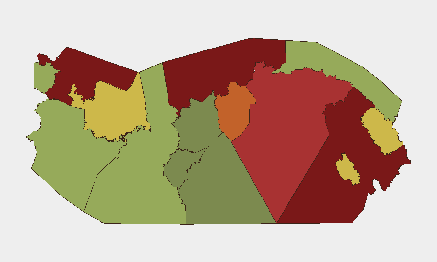
Darién, Colón, Bocas del Toro, and Panamá Province collectively drive the highest composite risk (scores 78–95), primarily due to gang violence, narcotics trafficking, and armed robbery. Darién remains the single highest-risk jurisdiction (95), reflecting its role as a primary transit corridor for cocaine, precursor chemicals, and migrant smuggling. Colón (88) and Bocas del Toro (82) face sustained drug-trafficking and gang-related homicide pressure tied to Caribbean and Central American trafficking networks. Panamá Province (78), which includes Panama City, shows elevated urban-crime risk driven by gang territorial disputes and armed robbery despite law-enforcement operations. Frontier and remote provinces (Ngäbe-Buglé, Emberá-Wounaan, Guna Yala) retain moderate-to-low ranked risk but limited state presence.
How GeoBit Would Assist
Security teams would use Intel Sweep and global event feeds for real-time situational updates on gang violence and narcotics enforcement. AOI Monitoring & Early Warning would enable persistent watch on Colón City, Darién border crossings, and canal approaches to detect emerging threats or operational changes. Network & Actor Analysis would map gang structure and drug-trafficking organization activity to anticipate violence hotspots and criminal displacement. Routing & Network Analysis would support alternative journey planning around high-risk zones and canal congestion zones during September transit cuts.
7-Day Outlook
Gang-related violence is expected to persist at current elevated levels; police operations (Operación Combate 2, Operación Centinela 2026) may displace rather than suppress criminal activity. Canal transit restrictions taking effect 3–15 September will increase shipping delays and congestion around Gatun Lake and Pacific approaches, raising logistics and security coordination demands for corporations with maritime assets or supply chains transiting the waterway.
Highest-Risk Areas — Ranked
| # | State / Region | Risk |
|---|---|---|
| 1 | Darién | 95 |
| 2 | Colón | 88 |
| 3 | Bocas del Toro | 82 |
| 4 | Panamá Province | 78 |
| 5 | Panamá Oeste | 75 |
| 6 | Ngäbe-Buglé | 68 |
| 7 | Emberá-Wounaan | 62 |
| 8 | Veraguas | 58 |
| 9 | Chiriquí | 48 |
| 10 | Naso Tjër Di | 45 |
| 11 | Guna Yala | 42 |
| 12 | Coclé | 35 |
Sources
Previous Daily Briefs
A new Panama brief is written every day — each with its own risk map and downloadable CSV. Here's the last week; use the calendar to go further back.
- August 22, 2026
- August 21, 2026
- August 20, 2026
- August 19, 2026
- August 18, 2026
- August 17, 2026
- August 16, 2026
📅 Browse every day by calendar →
Highlighted days have a brief. Tap a day for that day's map & analysis, or “csv” for that day's dataset ($5).
Atlas — our AI intelligence desk — emails them this snapshot personally. Nothing else, no list.