Situation Summary
Russia faces sustained, large-scale Ukrainian drone strikes targeting critical energy infrastructure across multiple regions, with deepening operational pressure on military assets and civilian supply chains. The 27–28 June mass drone barrage—described as among the heaviest of 2026—struck at least a dozen Russian regions plus occupied Crimea, with Moscow claiming interception of ~660 drones. Cumulative damage to refineries, power plants, and fuel distribution is degrading Russian operational capacity and civilian access to energy, while military losses (naval vessels, air-defense systems) signal Ukrainian capability to project force deeper into Russian territory. Risk trajectory remains elevated and volatile.
Key Developments
- Krasnodar Krai (Slavyansk-na-Kubani oil refinery), 27–28 June: Ukrainian drones struck the Slavyansk refinery, triggering a major fire and at least one confirmed fatality; regional governor and President Zelenskyy confirmed the strike.
- Yaroslavl Oblast (oil refinery), 27–28 June: Ukrainian forces struck a refinery ~700 km from Ukraine's border in the worst deep-strike campaign of the year; damage confirmed by Ukrainian and Russian sources.
- Crimea (Kerch region, power and fuel infrastructure), 27–28 June: Ukrainian drones hit oil reservoirs at the Kerch power plant, causing widespread blackouts affecting up to 50% of the peninsula; Russian-installed authorities banned civilian gasoline sales.
- Crimea (Kerch region, military targets), 27–28 June: Ukraine's Security Service reported strikes on two Russian military vessels and multiple air-defense systems as part of the mass barrage.
- Crimea (civil mobility), 27–28 June: Russian authorities closed the Kerch Bridge, declared a state of emergency, and halted all civilian fuel sales; critical supply and transport chokepoint now severely constrained.
- Tula Region (chemical/industrial), 27–28 June: Telegram and Russian state media reported drone strikes on the Azot chemical plant among targets in a nationwide barrage spanning 12+ regions plus occupied territory.
- Nationwide (air-defense tempo), 27–28 June: Russia's Defense Ministry reported interception of approximately 660 Ukrainian drones, a rate described by Tass as exceeding previous 2026 large-scale assaults.
Highest-Risk Areas
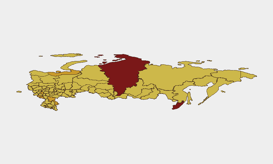
Moscow (risk 100) remains the primary focal point for corporate and government concentration, followed by Krasnoyarsk Krai (88.4) and Primorsky Krai (81.9)—regions with significant energy infrastructure and industrial capacity. Border and rear-area oblasts—Kursk (72.6), Belgorod (71.8), Volgograd (72.2)—face active military pressure and drone strike exposure; Krasnodar Krai (70.9) is now demonstrated as a target for deep-strike Ukrainian operations. The ranking reflects sustained warfare dynamics, energy infrastructure vulnerability, and cumulative attrition on civilian supply chains across southern and southwestern Russia.
How GeoBit Would Assist
Intelligence & OSINT (Intel Sweep, multi-language Telegram/X feeds, YouTube/podcast monitoring, OSINT fusion) enables real-time tracking of strikes, civilian impact, and infrastructure damage across fragmented Russian and Ukrainian sources. AOI Monitoring & Early Warning on high-risk regions (refineries, power plants, Kerch Bridge, transport hubs) provides persistent watch and alerting to teams with personnel or assets in affected zones. Conflict & Military (force structure, weapons-capability tracking, battle mapping) clarifies escalation patterns and Ukrainian strike reach, informing duty-of-care decisions on personnel location and supply-chain resilience.
7-Day Outlook
Ukrainian deep-strike drone capacity is demonstrating sustained range and tempo, with no clear degradation; Russian air-defense claims remain unverified independently. Energy infrastructure across southern Russia and Crimea will likely face continued targeting, driving further civilian supply disruption and potential population displacement. Risk in Moscow, Krasnodar, and critical infrastructure zones will remain elevated; corporate teams should expect continued volatility in logistics, power availability, and travel routing.
Highest-Risk Areas — Ranked
| # | State / Region | Risk |
|---|---|---|
| 1 | Moscow | 100 |
| 2 | Krasnoyarsk Krai | 88.4 |
| 3 | Primorsky Krai | 81.9 |
| 4 | Kursk Oblast | 72.6 |
| 5 | Nenets Autonomous Okrug | 72.2 |
| 6 | Volgograd Oblast | 72.2 |
| 7 | Saint Petersburg | 72.1 |
| 8 | Belgorod Oblast | 71.8 |
| 9 | Astrakhan Oblast | 71.5 |
| 10 | Tula Oblast | 71.5 |
| 11 | Krasnodar Krai | 70.9 |
| 12 | Kurgan Oblast | 70.7 |
Sources
Previous Daily Briefs
A new Russia brief is written every day — each with its own risk map and downloadable CSV. Here's the last week; use the calendar to go further back.
📅 Browse every day by calendar →
Highlighted days have a brief. Tap a day for that day's map & analysis, or “csv” for that day's dataset ($5).