Situation Summary
South Sudan remains elevated on GeoBit's global threat ranking (#22, composite score 72), with civil violence as the primary driver across 31 tracked events. The security environment is characterized by persistent intercommunal conflict, localized armed-group activity, and underlying state fragility; no major escalation or de-escalation has been detected in the past 48 hours. Recent diplomatic activity—including a South Sudan–Uganda border security coordination meeting—suggests incremental efforts to manage cross-border spillover, though implementation capacity remains limited. The overall trajectory is one of chronic instability rather than acute crisis, with risk concentrated in specific geographic corridors.
Key Developments
- No verified security incidents or disruptive events were detected in South Sudan during the 24–48 hour period ending 27 July 2026. Routine diplomatic activity (South Sudan–Uganda joint border-security committee reactivation, venue Arua District, Uganda) was noted but does not constitute a near-term operational security development for corporate assets or personnel.
- Watchlist status: Three event signals were flagged on 27 July (public statement on South Sudan vs. Africa, and two ministerial-level disapproval events involving South Sudan) but remain insufficiently detailed in available open-source results to assess materiality or operational relevance at this time.
Highest-Risk Areas
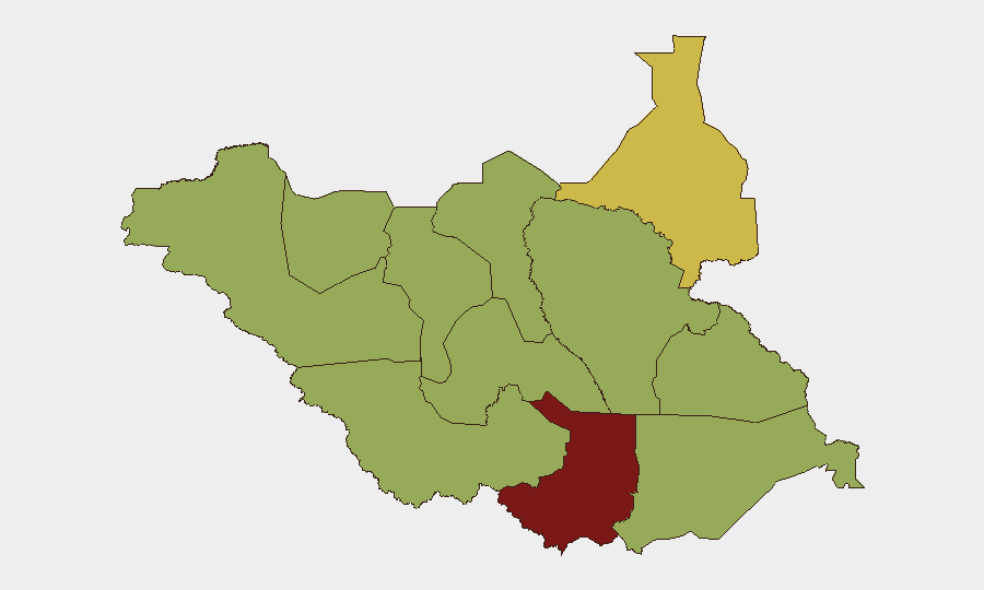
Central Equatoria (80.4) and Upper Nile (65.4) are the primary drivers of national risk, with Central Equatoria—home to the capital Juba and key economic/transit corridors—consistently experiencing the highest incident density and conflict-related activity. The remaining ten states and administrative areas cluster at or near a 50.4 composite score, reflecting widespread but less acute intercommunal and armed-group tensions across the pastoral and agricultural hinterlands (Northern Bahr el Ghazal, Western Bahr el Ghazal, Unity, Warrap, Lakes, Jonglei, Greater Pibor, and Eastern/Western Equatoria). Upper Nile's secondary ranking reflects active armed-group presence and border-adjacent instability. Risk dispersal across most subnational units indicates that threat mitigation and duty-of-care planning must be layered by location and asset type rather than concentrated in a single region.
How GeoBit Would Assist
Security and risk teams monitoring South Sudan would deploy AOI Monitoring & Early Warning to maintain persistent watch over high-risk administrative zones (Central Equatoria, Upper Nile, and border crossings) with automated alerting on civil-violence indicators and armed-group movement. Intel Sweep, OSINT fusion, and multi-language social media/Telegram monitoring enable early detection of emerging intercommunal tensions, political/ministerial statements, and armed-group messaging before incidents escalate to corporate impact. Routing & Network Analysis and GIS/Spatial Analysis support real-time journey planning for personnel and supply-chain assets, using conflict heat-maps and incident density to identify safe alternative routes and transit windows.
7-Day Outlook
No significant change in the baseline threat posture is anticipated over the next seven days. Continued diplomatic engagement on border security (South Sudan–Uganda coordination) may reduce immediate cross-border incident risk in specific transit zones, but implementation is likely to remain slow. Corporate teams should maintain current vigilance levels and sustain AOI monitoring for any acceleration in ministerial-level political activity, armed-group messaging, or localized intercommunal violence in Central Equatoria and Upper Nile.
Highest-Risk Areas — Ranked
| # | State / Region | Risk |
|---|---|---|
| 1 | Central Equatoria | 80.4 |
| 2 | Upper Nile | 65.4 |
| 3 | Northern Bahr el Ghazal | 50.4 |
| 4 | Western Bahr el Ghazal State | 50.4 |
| 5 | Ruweng Administrative Area | 50.4 |
| 6 | Unity | 50.4 |
| 7 | Warrap | 50.4 |
| 8 | Lakes | 50.4 |
| 9 | Jonglei | 50.4 |
| 10 | Greater Pibor Administrative Area | 50.4 |
| 11 | Western Equatoria | 50.4 |
| 12 | Eastern Equatoria | 50.4 |
Sources
Previous Daily Briefs
A new South Sudan brief is written every day — each with its own risk map and downloadable CSV. Here's the last week; use the calendar to go further back.
📅 Browse every day by calendar →
Highlighted days have a brief. Tap a day for that day's map & analysis, or “csv” for that day's dataset ($5).
Atlas — our AI intelligence desk — emails them this snapshot personally. Nothing else, no list.