Situation Summary
Sudan remains engulfed in active civil conflict with a composite threat score of 100 (rank #8 globally), characterized by mass displacement, collapsed humanitarian access, and widespread atrocities against civilians. The conflict continues to be operationally active across multiple regions, with security constraints limiting both movement and aid delivery. The national security environment shows no signs of near-term de-escalation, and risk remains severe for organizations with personnel or assets in-country.
Key Developments
- July 4, 2026 – National: Sudan's government issued an appeal to the international community and simultaneously released statements of disapproval, alongside UN statements on human rights violations. The exact operational significance of these statements remains unclear from available open-source reporting.
- July 4, 2026 – Civilian impact (location unspecified): Conventional military force was deployed against civilian populations; the precise location and scale remain undocumented in available open sources.
- July 4, 2026 – Diplomatic: Sudan-UAE relations deteriorated with Sudan issuing disapproval statements toward the UAE, signaling potential shifts in regional alignment or support flows.
- July 4, 2026 – Darfur region: A reduction in relations was noted; the parties and operational context are not clarified in available reporting.
- July 6, 2026 – Police/governance (location unspecified): Arrest and detention operations were conducted against police officers by Sudanese authorities, suggesting internal security or command-control issues within state institutions.
- July 6, 2026 – International (location unspecified): Arrests or detentions occurred involving Sudanese and French nationals; the nature, location, and operational context remain unclear.
Data caveat: Open-source reporting for July 4–6 lacks precise timestamps, exact locations, and multi-source confirmation for most events. Humanitarian organizations (UNHCR, IOM) confirm that conflict remains "very active" across multiple areas and that mass atrocities (including executions, starvation, and sexual violence) are ongoing, but specific incident-level reporting for the 24–48-hour window is not reliably available in public channels.
Highest-Risk Areas
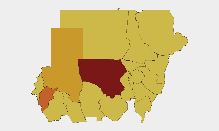
North Kordofan State (risk 100) is the single highest-threat region, followed by Central Darfur (74.8) and North Darfur (72.4), which together form the epicenter of active conflict and mass displacement. Blue Nile, River Nile, Al Khartum, Aj Jazira, Red Sea, Al Qadarif, Kassala, Sennar, and South Darfur all register at risk level 70 or above, indicating that conflict risk is geographically pervasive. The concentration of extreme risk in Darfur and North Kordofan reflects the primary theaters of civil war operations, while the elevation of Khartoum and riverine states signals governance collapse and secondary conflict spillover affecting the capital and transport corridors.
How GeoBit Would Assist
Teams with Sudanese operations should employ persistent AOI (area-of-interest) monitoring across high-risk states to receive automated alerts on new conflict activity, displacement, or security incidents. Intel Sweep and multi-language OSINT fusion (X/Telegram, YouTube, local media) combined with sentiment and temporal analysis can extract confirmed incident-level detail faster than public reporting lags. Battle mapping and force-structure tracking enable real-time route planning and movement risk assessment for personnel; alternative routing and network analysis capabilities can identify safer transit corridors as conditions shift.
7-Day Outlook
No immediate de-escalation is forecast. Humanitarian access constraints and active military operations are expected to persist or intensify across Darfur and North Kordofan. Organizations should assume increased checkpoints, detention risk, and restricted movement in high-risk states and prepare contingency protocols for rapid staff evacuation or shelter-in-place scenarios.
Highest-Risk Areas — Ranked
| # | State / Region | Risk |
|---|---|---|
| 1 | North Kordofan State | 100 |
| 2 | Central Darfur State | 74.8 |
| 3 | North Darfur State | 72.4 |
| 4 | Blue Nile | 70 |
| 5 | River Nile State | 70 |
| 6 | Al Khartum | 70 |
| 7 | Aj Jazira | 70 |
| 8 | Red Sea State | 70 |
| 9 | Al Qadarif State | 70 |
| 10 | Kassala State | 70 |
| 11 | Sennar State | 70 |
| 12 | South Darfur State | 70 |
Sources
Previous Daily Briefs
A new Sudan brief is written every day — each with its own risk map and downloadable CSV. Here's the last week; use the calendar to go further back.
📅 Browse every day by calendar →
Highlighted days have a brief. Tap a day for that day's map & analysis, or “csv” for that day's dataset ($5).
Atlas — our AI intelligence desk — emails them this snapshot personally. Nothing else, no list.