Situation Summary
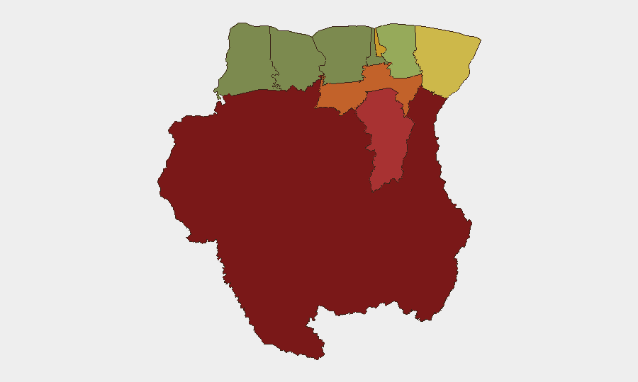
Suriname remains a lower-tier global security concern (composite threat score 4; no tracked events in the current reporting window). No credibly documented security incidents, civil unrest, or infrastructure disruptions have been verified in the last 24–48 hours across major Surinamese news outlets, regional aggregators, or open-source intelligence feeds. Risk is concentrated in interior districts (Sipaliwini, Brokopondo, Para) where drug trafficking, informal mining, and limited state presence create persistent but localized exposure; the capital and coastal regions maintain significantly lower incident rates.
Key Developments
No discrete security or civil-unrest incidents meeting the 24–48 hour recency standard have been independently confirmed as of 6 August 2026. Recent items in Surinamese crime reporting (e.g., rental-car fire on Saramaccastraat, drug-swallowing arrest on 2 August, suspected boat capsize in the Matawai area on 30 July) predate the current window and do not constitute active developments. Monitoring of domestic news portals (Suriname Nieuws Centrale, Waterkant, Starnieuws, SRNieuws) and aggregated feeds (Drimble, Times of Suriname) confirms no new incidents in the specified timeframe.
Highest-Risk Areas
Interior districts dominate the risk ranking: Sipaliwini (risk 92), Brokopondo (risk 78), and Para (risk 74) together account for structural vulnerability to drug trafficking, artisanal and informal mining operations, and limited government oversight. These areas, particularly Sipaliwini in the far south, remain conduits for narcotics movement through Guyana and regional supply chains, with sporadic arrests of armed foreign nationals in rainforest zones. Paramaribo (risk 71) and Marowijne (risk 68) reflect urban and border-adjacent crime exposure (robbery, assault, organized-crime networks), while coastal and western districts (Coronie, Nickerie, Saramacca) show substantially lower incident density and are suitable for routine operations.
How GeoBit Would Assist
A corporate security team with personnel or assets in Suriname should employ Area-of-Interest (AOI) monitoring focused on high-risk districts (Sipaliwini, Brokopondo, Para, Paramaribo) to receive early alerting on trafficking, unrest, or infrastructure disruptions. Multi-language OSINT (Intel Sweep, entity extraction, and sentiment/temporal analysis) applied to Surinamese news, social media, and local radio will surface emerging crime, protest activity, or political instability faster than English-language wire services. GIS and spatial analysis enables mapping of incidents, trafficking routes, and safe/restricted zones by district, supporting informed travel routing and asset-location decisions.
7-Day Outlook
No significant escalation indicators are visible in the current window; the threat environment is expected to remain stable at the national level through mid-August, with risk concentrated in interior zones. Ongoing drug-trafficking activity and informal mining will persist as chronic stressors in Sipaliwini and Brokopondo, but no discrete trigger events (political instability, major criminal incident, infrastructure failure) are forecast to materialize in the near term. Teams should maintain routine security posture and continue passive monitoring of interior-district activity via OSINT feeds.
Highest-Risk Areas — Ranked
| # | State / Region | Risk |
|---|---|---|
| 1 | Sipaliwini | 92 |
| 2 | Brokopondo | 78 |
| 3 | Para | 74 |
| 4 | Paramaribo | 71 |
| 5 | Marowijne | 68 |
| 6 | Commewijne | 42 |
| 7 | Wanica | 38 |
| 8 | Saramacca | 29 |
| 9 | Coronie | 12 |
| 10 | Nickerie | 8 |
Sources
- geobit.ai
- surinamenieuwscentrale.com
- surinamenieuwscentrale.com
- surinamenieuwscentrale.com
- drimble.nl
- surinametimes.com
- surinamenieuwscentrale.com
- surinamesuntimes.com
- surinametimes.com
- desnellepen.com
- waterkant.net
- surinamenieuwscentrale.com
- srnieuws.com
- youtube.com
- starnieuws.com
- whitehouse.gov
- openssf.org
- pinsentmasons.com
Previous Daily Briefs
A new Suriname brief is written every day — each with its own risk map and downloadable CSV. Here's the last week; use the calendar to go further back.
📅 Browse every day by calendar →
Highlighted days have a brief. Tap a day for that day's map & analysis, or “csv” for that day's dataset ($5).
Atlas — our AI intelligence desk — emails them this snapshot personally. Nothing else, no list.