Situation Summary
Syria remains at composite threat level 85 (#13 globally), driven primarily by ongoing civil-conflict dynamics and now compounded by acute escalation along the southern border with Israel. The last 48 hours have seen a marked spike in Israeli military incursions, shelling, and armed engagement in Daraa and Quneitra governorates, coupled with domestic protest activity and sporadic insurgent attacks against state security infrastructure in the east. The convergence of these signals—external military pressure, internal political tension around transitional governance, and localized militant activity—has elevated near-term risk in southern and central Syria.
Key Developments
- Southern Syria (Daraa/Quneitra border area) – 28–29 June 2026:
Israeli forces conducted multiple shelling and artillery strikes on the village of Abidin/Abdeen in western Daraa countryside, with helicopter overflights reported over Quneitra and Daraa; the Syrian Foreign Ministry condemned the incursions as violations of the 1974 Disengagement Agreement, and residents were displaced.
- Southern Syria (Golan/ceasefire line) – night of 28 June 2026:
Armed exchange reported between IDF troops and gunfire from inside southern Syrian territory, characterized in regional media as part of an escalating pattern along the frontier and linked to concurrent Israeli shelling operations.
- Deir ez-Zor city (bridge checkpoint area) – 29 June 2026:
An Internal Security checkpoint was struck by RPG fire from unidentified gunmen, indicating ongoing insurgent or militant activity targeting state security positions in eastern Syria.
- Nationwide (Idlib, Aleppo, Hama, Deir ez-Zor, Damascus) – continuing into late June 2026:
Demonstrations in multiple governorates demanding accountability for conflict-related crimes; some protests have involved violence, reflecting domestic political tension surrounding the transitional parliament and prosecutions of former regime officials.
- Regional diplomatic response – 29 June 2026:
The Syrian Foreign Ministry, Arab Parliament, and Arab League issued formal statements warning that continued Israeli military violations risk broader regional escalation and called for UN intervention.
Highest-Risk Areas
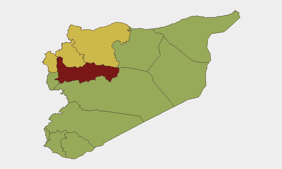
Hama Governorate leads the sub-national risk ranking (89.3), driven by the overlay of residual conflict-zone volatility and proximity to both central Syria's fragile transition and northern border dynamics. Damascus Governorate (72.9) reflects the concentration of state institutions, protest activity, and transitional-governance tension. Southern governorates—Daraa, Quneitra, and the UNDOF-monitored zone (all 59.3)—have emerged as acute flashpoints due to the 28–29 June Israeli incursions and the vulnerability of the 1974 ceasefire architecture. The elevation of Aleppo (69.7) and Idleb (69.3) reflects ongoing militant and opposition-linked activity, compounded by the recent wave of nationwide accountability protests.
How GeoBit Would Assist
Security teams should deploy AOI Monitoring & Early Warning on Daraa, Quneitra, and the Golan buffer zone to detect further Israeli incursions or escalatory signals in real time. Conflict & Military tracking (force structure, weapons-capability assessment, battle mapping) and OSINT fusion—via Intel Sweep, social-media intelligence, and multi-language feeds—will provide early indicators of Syrian or regional military repositioning. Satellite & Imagery analysis of southern border areas and checkpoint locations can corroborate incident reports and track displacement or force movement; Network & Actor Analysis will help identify the gunmen responsible for the Deir ez-Zor RPG attack and map protest-organizer networks in key governorates.
7-Day Outlook
Israeli military activity along the southern ceasefire line is likely to persist or escalate if diplomatic de-escalation does not gain traction within 72 hours. Domestic protest momentum in Damascus and northern governorates will probably continue, with risk of security-force clashes, especially around transitional-justice proceedings. Militant activity in Deir ez-Zor and eastern Syria remains endemic; watch for further checkpoint or infrastructure attacks.
Highest-Risk Areas — Ranked
| # | State / Region | Risk |
|---|---|---|
| 1 | Hama Governorate | 89.3 |
| 2 | Damascus Governorate | 72.9 |
| 3 | Aleppo Governorate | 69.7 |
| 4 | Idleb Governorate | 69.3 |
| 5 | Lattakia Governorate | 60.7 |
| 6 | Tartus Governorate | 59.3 |
| 7 | UNDOF | 59.3 |
| 8 | Al-Quneitra Governorate | 59.3 |
| 9 | Dar'a Governorate | 59.3 |
| 10 | Ar-Raqqa Governorate | 59.3 |
| 11 | Homs Governorate | 59.3 |
| 12 | Rif Dimashq Governorate | 59.3 |
Sources
Previous Daily Briefs
A new Syria brief is written every day — each with its own risk map and downloadable CSV. Here's the last week; use the calendar to go further back.
📅 Browse every day by calendar →
Highlighted days have a brief. Tap a day for that day's map & analysis, or “csv” for that day's dataset ($5).