Situation Summary
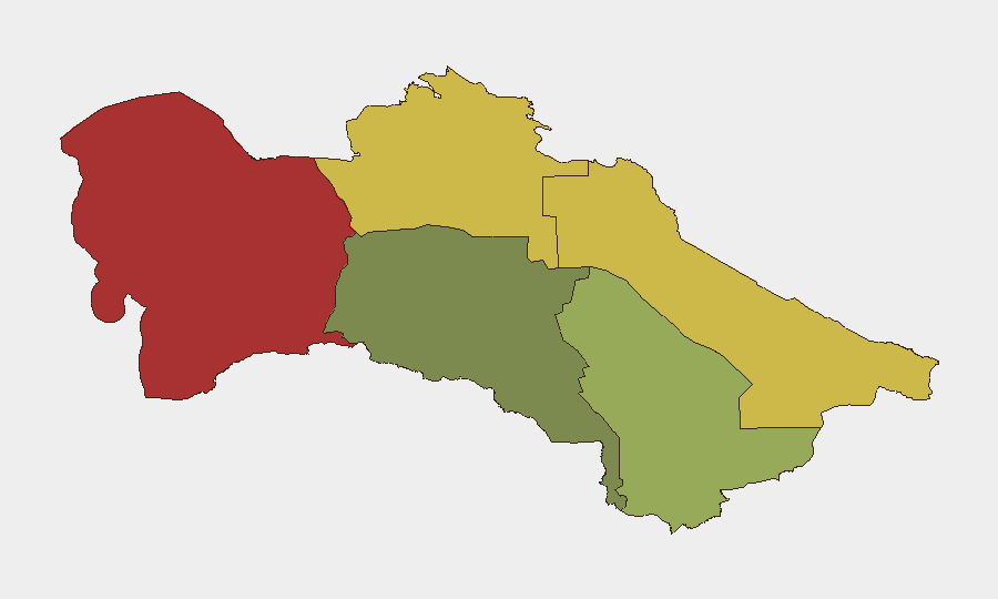
Turkmenistan maintains a low composite threat profile (rank #null globally, score 3) with no tracked discrete security events in the current reporting window. The country's overall stability remains underpinned by strong state control, though regional disparities in risk are pronounced, with the Balkan Region (78) and Lebap Region (68) significantly outpacing the capital. No major security, infrastructure, or civil unrest incidents were confirmed in the last 24–48 hours; diplomatic activity (U.S.–Turkmen bilateral meetings on 22 July) and energy sector developments proceed within normal parameters.
Key Developments
No confirmed security, unrest, crime, or infrastructure incidents meeting the 24–48-hour threshold were identified in available open sources. Recent reporting consists primarily of government announcements and background coverage not clearly timestamped to the last two days. Teams should note that Turkmenistan's media environment is highly state-controlled, and independent incident reporting is limited; absence of public reporting does not indicate absence of risk, particularly in peripheral regions.
Highest-Risk Areas
The Balkan Region's elevated risk score (78) reflects its historical position as a transit corridor for contraband and its geographic remoteness from capital oversight; Lebap Region (risk 68) exhibits similar patterns, with added pressure from cross-border dynamics. In contrast, Ashgabat City (18) and Ahal Region (35) show substantially lower composite risk, consistent with heavier state security presence and greater economic integration. Mary Region (42) occupies a middle position, driven partly by energy-sector infrastructure dependencies and seasonal labor patterns. Security teams with operations in Balkan or Lebap should anticipate elevated baseline vigilance around movement, customs, and supply-chain vulnerabilities.
How GeoBit Would Assist
Teams operating in or transiting Turkmenistan would benefit from AOI Monitoring & Early Warning focused on Balkan, Lebap, and Dashoguz regions to detect emerging incidents or movement patterns before they escalate; Intel Sweep and multi-language search capabilities to parse state and diaspora media for oblique references to unrest or infrastructure disruption that formal channels may obscure; and Routing & Network Analysis to identify alternative journey corridors and cross-border contingencies in high-risk areas. Satellite & Imagery analysis can support asset-location verification and infrastructure continuity planning, particularly for energy and transport nodes.
7-Day Outlook
Near-term trajectory remains stable absent exogenous shocks (regional conflict spillover, commodity price shocks, or diplomatic escalation). Seasonal patterns (summer heat, reduced mobility) typically favor low incident rates. Teams should maintain standard duty-of-care vigilance and monitor GeoBit alerts for any uptick in regional signals, particularly in Balkan Region, where reporting opacity creates early-warning blind spots.
Next Brief: 2026-07-24 | Report Confidence: Low (limited open-source incident data) | Duty-of-Care Recommendation: Standard monitoring; escalate to enhanced protocols if travel or operations expand into Balkan or Lebap regions.
Highest-Risk Areas — Ranked
| # | State / Region | Risk |
|---|---|---|
| 1 | Balkan Region | 78 |
| 2 | Lebap Region | 68 |
| 3 | Dashoguz Region | 62 |
| 4 | Mary Region | 42 |
| 5 | Ahal Region | 35 |
| 6 | Ashgabat City | 18 |
Sources
Previous Daily Briefs
A new Turkmenistan brief is written every day — each with its own risk map and downloadable CSV. Here's the last week; use the calendar to go further back.
📅 Browse every day by calendar →
Highlighted days have a brief. Tap a day for that day's map & analysis, or “csv” for that day's dataset ($5).
Atlas — our AI intelligence desk — emails them this snapshot personally. Nothing else, no list.