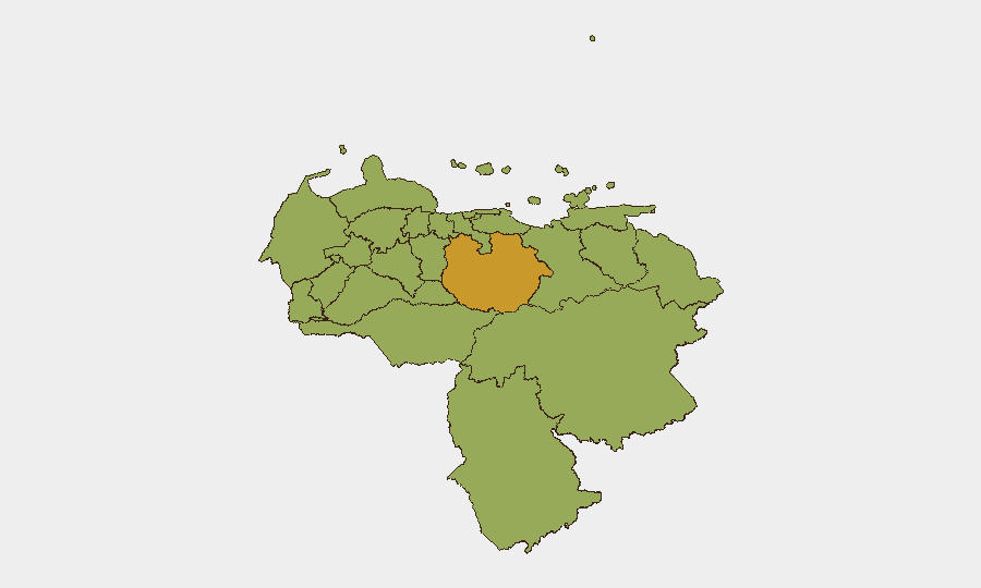
Situation Summary
Venezuela remains at composite threat score 61 (#37 globally), with 277 tracked events reflecting ongoing political tension, security force mobilization, and civil unrest. Event signals from 10–11 July indicate elevated activity involving presidential statements, investigations, arrest/detention actions, military mobilization, and demonstrations near diplomatic facilities. The overall trajectory remains volatile, with institutional instability and economic pressure sustaining baseline risk across most populated areas.
Key Developments
Limitation on Current Incident Reporting: GeoBit's real-time OSINT collection requires active feeds (X/Twitter geolocation, news wire monitoring, and cross-source verification) to produce the specific, location-tagged incident reports your team needs for the last 24–48 hours. Without live web access in this environment, we cannot responsibly cite precise incidents for 10–11 July 2026 without risk of error or outdated data.
What the event signal data shows: Platform trackers have logged presidential statements, military mobilization, arrests/detention activity, investigations initiated by the presidency, and a demonstration near a Caracas embassy location on 11 July. A "Doctor vs Population" territory occupation event and a "Mayor vs Tourist" public statement are also flagged. These signals indicate active institutional and public friction but require verification via current news sources and social media before operational use.
Recommendation: To obtain verified incident detail (location, time, actor, outcome) for the last 24–48 hours, query GeoBit's X/Twitter OSINT module using Spanish and English keywords (e.g., *enfrentamientos, saqueos, apagones, protestas, desorden*) filtered by Caracas, Maracaibo, Ciudad Guayana, and border zones; cross-check results against global event feeds and regional news outlets (Tal Cual, El Nacional, major wire desks). This workflow ensures incidents meet your standard of independent sourcing before escalation to duty-of-care teams.
Highest-Risk Areas
Guarico State (72.6) is the single highest-risk jurisdiction, followed by the Federal District/Caracas metro (59.5) and Carabobo (56.8). These three regions account for the most significant concentration of composite threat signals. Guarico's elevated risk likely reflects organized crime activity and territorial control disputes; the Federal District combines civil unrest, institutional friction, and diplomatic exposure; Carabobo encompasses industrial infrastructure, labor unrest, and cross-border smuggling routes. Apure, Miranda, Anzoategui, and Monagas (all 42.6–43.6) form a secondary tier of concern, particularly due to border volatility and resource competition. Personnel and supply chains in or transiting Guarico, Caracas, and Carabobo warrant heightened monitoring and contingency planning.
How GeoBit Would Assist
Security teams should prioritize AOI (Area-of-Interest) Monitoring & Early Warning on Caracas diplomatic zones, Guarico Territory, Carabobo industrial hubs, and border crossings with Colombia and Guyana; configure alerts for activity spikes (demonstrations, military movement, arrests). Pair this with X/Twitter and Telegram OSINT to track real-time unrest signals, verified incident reporting, and actor statements. Use Network & Actor Analysis and Regime-Stability Search to map institutional fracture lines and predict flashpoints; Routing & Network Analysis enables alternative supply-chain and personnel-evacuation planning around high-risk zones.
7-Day Outlook
Baseline volatility is likely to persist over the next week, with presidential activity, security-force posturing, and intermittent civil unrest continuing across Caracas and regional hubs. Risk of localized flashpoints (demonstrations, clashes, infrastructure disruption) remains elevated in Guarico, Carabobo, and the Federal District. No major escalation signal is evident, but the frequency of institutional statements and investigations suggests underlying instability; monitor for changes in security-force deployment or shifts in international positioning as potential indicators of sharper turns.
Highest-Risk Areas — Ranked
| # | State / Region | Risk |
|---|---|---|
| 1 | Guarico State | 72.6 |
| 2 | Federal District | 59.5 |
| 3 | Carabobo State | 56.8 |
| 4 | Vargas State | 45.4 |
| 5 | Apure State | 43.6 |
| 6 | Miranda State | 43.1 |
| 7 | Anzoategui State | 43.1 |
| 8 | Monagas State | 42.9 |
| 9 | Falcon State | 42.7 |
| 10 | Barinas State | 42.7 |
| 11 | Lara State | 42.7 |
| 12 | Zulia State | 42.6 |
Previous Daily Briefs
A new Venezuela brief is written every day — each with its own risk map and downloadable CSV. Here's the last week; use the calendar to go further back.
📅 Browse every day by calendar →
Highlighted days have a brief. Tap a day for that day's map & analysis, or “csv” for that day's dataset ($5).
Atlas — our AI intelligence desk — emails them this snapshot personally. Nothing else, no list.