Situation Summary
Benin experienced a failed military coup attempt in Cotonu on 1–2 August 2026, during which soldiers briefly announced suspension of the constitution and removal of President Patrice Talon. Gunfire and airstrikes (reportedly conducted with Nigerian support) erupted near the presidential palace and national TV station; by Sunday evening, authorities stated the situation was "under control," though security operations continued. Concurrent with this political shock, northern Benin remains under sustained jihadist and trafficking pressure, exemplified by the late-July seizure of 500 kg of explosives en route to Malanville. The country faces a critical stabilization window with heightened volatility across governance, northern insurgency, and transnational crime vectors.
Key Developments
- Cotonou – Failed coup attempt, 1–2 August 2026: Military announced constitutional suspension and President Talon's removal on state TV early Sunday; gunfire reported near presidential palace and explosions (attributed to Nigerian airstrikes) followed. President Talon declared situation "totally under control" by Sunday evening; security forces continued hunting remaining plotters.
- Cotonou – Detention and hostage rescue, 1 August 2026: Authorities arrested 14 individuals, including 12 suspects linked to storming the national TV offices; two high-ranking military officers held as hostages were rescued, though operational details remain unclear and presence of other captives unknown.
- Northern Benin (Sonahoulou–Djougou road, Anoum checkpoint) – Explosives seizure, late July / reported within 48 hours: Customs' Regional Fraud Prevention Service intercepted 3,295 sticks of explosives (≈500 kg) bound from Togo to Malanville; seizure underscores trafficking and jihadist-linked supply concerns in the north.
- Porto‑Novo (1st district) – Criminal network dismantled, reported within 48 hours: Republican Police disrupted a burglary and motorcycle-theft gang operating in Porto‑Novo and surrounding areas, indicating ongoing urban property-crime risk in the capital region.
- Grand‑Popo (Sazué district) – Counterfeit drug seizure, reported within 24–48 hours: Police arrested a motorcycle-taxi driver carrying 95 kg of illicit pharmaceuticals, reflecting health-security and narcotics-trafficking enforcement in the southwest.
- Parakou and Tchaourou (Borgou Department) – Fuel station seals, reported within 24–48 hours: National Agency for Standardization, Metrology and Quality Control sealed six fuel pumps for non-compliance, affecting local fuel availability and travel logistics in central Benin.
- Godomey (Cotonou area) – Human skull discovery and arrests, current local news: Police found a human skull in a tricycle and arrested two individuals; discovery points to possible serious criminal or ritual-related activity under investigation.
Highest-Risk Areas
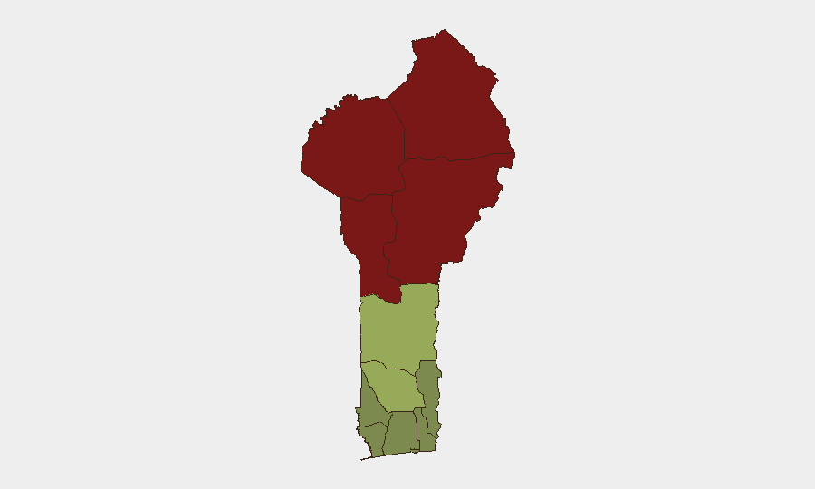
Alibori, Atakora, Donga, and Borgou departments (northern and north-central Benin) drive the country's composite threat score, with risk scores ranging from 83 to 92. These zones are characterized by persistent jihadist activity, porous borders with Burkina Faso and Niger, and active explosives and arms trafficking networks. The recent seizure of 500 kg of explosives on the Sonahoulou–Djougou road and the concentration of northern threat signals confirm that the north remains the primary driver of national instability. Southern and coastal departments (Atlantique, Littoral, Ouémé) register substantially lower scores but continue to experience urban crime and contraband-related risks.
How GeoBit Would Assist
Security teams should deploy AOI Monitoring & Early Warning on high-risk northern departments and key border crossings (Malanville, Anoum checkpoint) to track explosives and arms trafficking in real time. Intel Sweep (OSINT fusion, Telegram/X monitoring, entity extraction, and sentiment analysis) provides early signals of political fragmentation and coup plotting—critical for governance-risk assessment post-1 August. Routing & Network Analysis supports alternative-route planning for personnel and cargo movements, circumventing checkpoints and conflict zones. Conflict & Military tracking of force posture and external military support (e.g., Nigerian airstrikes) informs escalation scenarios.
7-Day Outlook
Political consolidation around President Talon and residual security sweeps will dominate the immediate 7-day period; risk of secondary coup attempts or mutiny remains elevated. Northern jihadist and trafficking networks are unlikely to be disrupted by the coup distraction and may accelerate cross-border operations. International attention and potential military reinforcement should dampen large-scale violence in Cotonou, but urban crime and northern trafficking will persist.
Highest-Risk Areas — Ranked
| # | State / Region | Risk |
|---|---|---|
| 1 | Alibori Department | 92 |
| 2 | Atakora Department | 88 |
| 3 | Donga Department | 85 |
| 4 | Borgou Department | 83 |
| 5 | Zou Department | 45 |
| 6 | Collines Department | 42 |
| 7 | Plateau Department | 38 |
| 8 | Kouffo Department | 35 |
| 9 | Mono Department | 32 |
| 10 | Atlantique Department | 28 |
| 11 | Littoral | 25 |
| 12 | Ouémé Department | 22 |
Sources
Previous Daily Briefs
A new Benin brief is written every day — each with its own risk map and downloadable CSV. Here's the last week; use the calendar to go further back.
📅 Browse every day by calendar →
Highlighted days have a brief. Tap a day for that day's map & analysis, or “csv” for that day's dataset ($5).
Atlas — our AI intelligence desk — emails them this snapshot personally. Nothing else, no list.