Situation Summary
Bhutan remains among the safest countries in Asia, with no confirmed security incidents, civil unrest, conflict, or infrastructure disruptions in the current 48-hour window. The composite national threat score stands at 3 (rank #179 globally), and no discrete events are currently tracked. The security environment is stable, with routine government and administrative activity proceeding without disruption.
Key Developments
- Bhutan nationwide (2026-08-28 to 2026-08-29) — No confirmed security, civil unrest, crime, conflict, or infrastructure incidents identified in the latest 48-hour monitoring window.
- Bhutan nationwide (2026-08-27 to 2026-08-29) — Travel-risk summaries classify Bhutan as one of Asia's safest destinations, with no government travel advisories against any district or region.
- India-Bhutan border, Assam districts (2026-08-28) — Indian border security conducted routine preparedness checks along the Tamulpur and Udalguri border segments. Assessment was preparedness-focused rather than incident-response-driven, indicating no active security event on the Bhutan side.
- Bhutan nationwide (2026-08-28) — Government and education ministry administrative pages showed standard business: routine meetings, policy announcements, and departmental coordination. No emergency declarations or security-related announcements were issued.
- Himalayan region (2026-08-28 to 2026-08-29) — Regional flooding alerts centered on Nepal and Tibet; no confirmed flood disruption or infrastructure damage was reported in Bhutan during the monitoring period.
Highest-Risk Areas
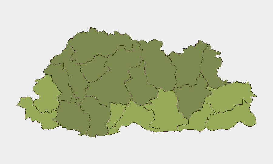
Samtse, Sarpang, and Haa districts rank as the highest-risk sub-national zones (composite scores 58, 55, and 52 respectively), all located in Bhutan's southern and southwestern border regions. These districts' elevated risk profiles reflect proximity to India, cross-border trade flows, and terrain factors; however, no current incident activity or escalation triggers have been identified in any of these areas. The southern-tier districts (Samtse through Pemagatshel) collectively account for the top five risk rankings, suggesting that border-adjacent and lower-altitude zones warrant proportionally greater monitoring, even though absolute risk remains low.
How GeoBit Would Assist
Security teams with personnel or assets in Bhutan should deploy Area-of-Interest (AOI) Monitoring & Early Warning on Samtse, Sarpang, and Haa districts to track cross-border activity, infrastructure disruptions, or civil-unrest signals in real time. Border & Disputed-Territory Search and OSINT Fusion (multi-language, multi-source corroboration) would provide continuous coverage of India-Bhutan boundary dynamics and regional conflict spillover risk. Environmental & Health monitoring would flag flooding, landslide, or weather-driven access disruptions before they impact operations.
7-Day Outlook
No escalation or significant incident activity is anticipated in Bhutan over the next seven days. Border conditions are expected to remain stable, and routine administrative and commercial activity should continue uninterrupted. Security teams should maintain standard duty-of-care protocols and periodic monitoring of the higher-risk southern districts, but no surge in threat level or operational constraints is forecast.
Highest-Risk Areas — Ranked
| # | State / Region | Risk |
|---|---|---|
| 1 | Samtse District | 58 |
| 2 | Sarpang District | 55 |
| 3 | Haa District | 52 |
| 4 | Pemagatshel District | 50 |
| 5 | Samdrup Jongkhar District | 48 |
| 6 | Tsirang District | 45 |
| 7 | Zhemgang District | 42 |
| 8 | Trashigang District | 40 |
| 9 | Mongar District | 38 |
| 10 | Gasa District | 35 |
| 11 | Lhuntse District | 32 |
| 12 | Wangdue Phodrang District | 30 |
Sources
Previous Daily Briefs
A new Bhutan brief is written every day — each with its own risk map and downloadable CSV. Here's the last week; use the calendar to go further back.
- August 26, 2026
- August 23, 2026
- August 21, 2026
- August 18, 2026
- August 16, 2026
- August 14, 2026
- August 12, 2026
📅 Browse every day by calendar →
Highlighted days have a brief. Tap a day for that day's map & analysis, or “csv” for that day's dataset ($5).
Atlas — our AI intelligence desk — emails them this snapshot personally. Nothing else, no list.