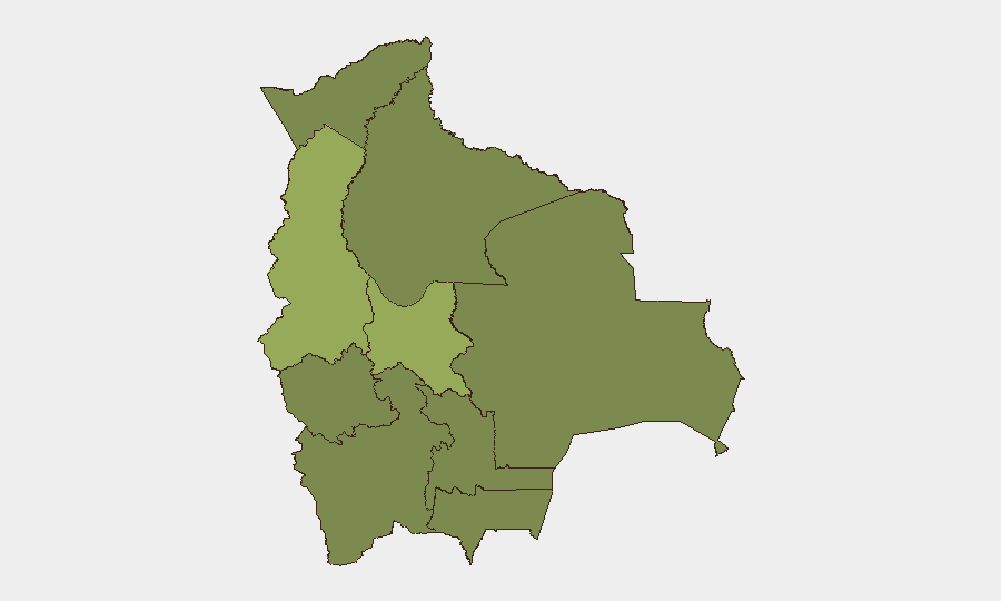
Situation Summary
Bolivia remains under a nationwide state of emergency declared in late June 2026 following sustained anti-government protests and roadblocks led by Evo Morales supporters. Security forces have expanded powers to clear blockades, but open-source reporting does not yet clearly document specific, time-stamped incidents within the last 24–48 hours; the overall security environment remains volatile with persistent risk of confrontation at protest sites, supply-route disruptions, and political instability. Cochabamba and La Paz are significantly more affected than other regions, with risk scores of 57.9 and 53.1 respectively, reflecting both the scale of mobilization and prior casualty counts in those areas.
Key Developments
Note: Open web research and social signals do not currently yield clearly time-stamped, verifiable security incidents specific to July 1–2, 2026. The following summarizes the ongoing, active risk environment rather than discrete new events:
- Nationwide state of emergency – Continuing – President Rodrigo Paz's declaration remains in effect, granting security forces expanded authority to clear blockades and suppress protests. This framework has been in place since late June and remains the operational context for all current security operations.
- La Paz and Altiplano region – Dozens of active or intermittent roadblocks – Multiple analyses confirm that roadblocks persist across La Paz and at least six of nine departments, often employing dynamite and other weapons. Protest groups have repeatedly re-established blockades even after police clearance, creating persistent travel and cargo risks.
- Supply-route disruptions – Nationwide impact – Fuel, food, and essential goods distribution continues to be disrupted by blockades on major highways, constraining logistics and creating economic pressure that incentivizes further protest action.
- Prior casualty baseline – Context for escalation risk – Earlier confrontations in June 2026 resulted in at least 10 deaths, 37 injuries, and over 100 prosecutions; the same radicalized syndicates and grievances remain mobilized, indicating that any new confrontation could reach similar violence levels.
- Political power struggle – Ongoing governance crisis – Morales and allied groups continue to seek President Paz's resignation and new elections, sustaining institutional tension and increasing the likelihood of sudden protest surges around government facilities.
- International travel advisory – Current advisory level elevated – The UK Foreign Office's guidance to "reconsider need to travel" and avoid demonstrations remains current, reflecting persistent instability.
Highest-Risk Areas
Cochabamba (57.9) and La Paz (53.1) drive national risk and are separated from all other regions by a margin of 26+ points, indicating concentrated vulnerability in the central highlands and capital region. Cochabamba has been a locus of Morales-aligned mobilization and radical syndicates; La Paz, as the political and administrative center, faces dual pressure from blockades disrupting supply and institutional crises around government facilities. The remaining seven departments cluster at 27.9, suggesting more dispersed but lower-intensity risk outside the two hotspots.
How GeoBit Would Assist
AOI Monitoring & Early Warning would enable persistent watch of Cochabamba, La Paz, and key highway nodes, with alerting on new blockade formation or security-force movements. Routing & Network Analysis would support duty-of-care teams in identifying alternative supply and personnel routes around active blockades in real time. Conflict & Military tracking combined with OSINT fusion (X/Twitter, Telegram, radio SIGINT) would corroborate emerging incidents and distinguish rumors from confirmed events as they occur.
7-Day Outlook
The state of emergency framework is likely to persist through the near term, with continued sporadic blockade clearance and re-establishment cycles. Risk of a significant escalation event (mass casualty clash, blockade of critical infrastructure, or sudden political transition) remains elevated but episodic; no specific catalyst is evident in current reporting. Security teams should expect operational disruptions to continue and maintain persistent monitoring of La Paz and Cochabamba.
Highest-Risk Areas — Ranked
| # | State / Region | Risk |
|---|---|---|
| 1 | Cochabamba | 57.9 |
| 2 | La Paz | 53.1 |
| 3 | Potosí | 27.9 |
| 4 | Tarija | 27.9 |
| 5 | Pando | 27.9 |
| 6 | Beni | 27.9 |
| 7 | Oruro | 27.9 |
| 8 | Chuquisaca | 27.9 |
| 9 | Santa Cruz | 27.9 |
Sources
Previous Daily Briefs
A new Bolivia brief is written every day — each with its own risk map and downloadable CSV. Here's the last week; use the calendar to go further back.
📅 Browse every day by calendar →
Highlighted days have a brief. Tap a day for that day's map & analysis, or “csv” for that day's dataset ($5).