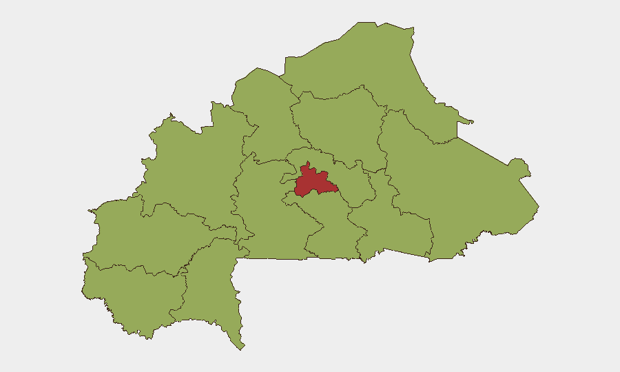
Situation Summary
Burkina Faso remains in a persistent, high-threat environment driven primarily by active insurgent operations across multiple regions, with a composite national threat score of 67 (rank #24 globally). The security landscape is characterized by sporadic but severe attacks on military and civilian targets, kidnapping and banditry outside major urban centers, and underlying inter-state tensions (notably recent clashes with Niger forces in early July). While no incident-level security events have been independently verified in the past 24–48 hours, the absence of reported activity reflects ongoing data constraints in the Sahel rather than a genuine reduction in underlying threat; structural conditions supporting insurgent operations remain unchanged.
Key Developments
No credible, incident-level security events have been independently verified in Burkina Faso during the 24–48 hour period preceding this brief (as of 26 July 2026). Open-source reporting, social-media monitoring, and field-source data do not confirm discrete attacks, clashes, or major unrest in that specific window. This absence reflects typical verification lags in remote, conflict-affected regions rather than improved security conditions.
Context (outside 24–48h window):
- Djibo repelled attack (19–20 July): Burkinabè defence forces reported defeating a significant terrorist assault with heavy attacker losses; event is 6+ days old and outside the current reporting window.
- Burkina–Niger border tension (5 July): Four conventional military engagements reported near the border, indicating serious inter-state friction; nearly three weeks old.
Highest-Risk Areas
Centre region dominates the risk landscape (score 77), substantially higher than all other regions (scores of 47), and is the primary driver of the national threat score. This concentration reflects the geographic proximity of Centre to Ouagadougou and its role as a staging ground for insurgent operations targeting the capital and surrounding zones. Nine other regions (Upper-Basins, Boucle du Mouhoun, Central-West, Central-South, Central-East, Waterfalls, Southwest, Sahel, Central-North, East, and North) present uniformly elevated risk (47 each), indicating that threat is distributed rather than isolated, and that no region outside Centre can be considered genuinely safe for unescorted movement. Even Ouagadougou and Bobo-Dioulasso, the two largest cities, face non-negligible risk of terrorist attack despite their relative security infrastructure.
How GeoBit Would Assist
A corporate security team operating in Burkina Faso should employ AOI Monitoring & Early Warning on Centre region and border zones to detect pattern changes in insurgent activity and military movements before kinetic events occur. OSINT Fusion & Corroboration (Intel Sweep, multi-language social-media and radio monitoring, entity extraction) provides near-real-time visibility into credible incident reporting and allows rapid distinction between rumor and verified threat. Routing & Network Analysis and Conflict & Military intelligence support secure movement planning and situational awareness of force dispositions that may affect personnel transit.
7-Day Outlook
The near-term trajectory is likely to remain consistent with current conditions: persistent, distributed insurgent pressure particularly in Centre and northern regions, without a clear de-escalation pathway. Political tensions (notably ECOWAS–Burkina Faso friction as of 24 July) and ongoing military operations create cumulative friction that could trigger secondary incidents. Risk levels are expected to remain in the "high" to "very high" band; duty-of-care teams should assume no material improvement in the 7-day horizon and maintain heightened operational security protocols.
Highest-Risk Areas — Ranked
| # | State / Region | Risk |
|---|---|---|
| 1 | Centre | 77 |
| 2 | Upper-Basins | 47 |
| 3 | Boucle du Mouhoun | 47 |
| 4 | Central-West | 47 |
| 5 | Central-South | 47 |
| 6 | Central-East | 47 |
| 7 | Waterfalls | 47 |
| 8 | Southwest | 47 |
| 9 | Sahel | 47 |
| 10 | Central-North | 47 |
| 11 | East | 47 |
| 12 | North | 47 |
Sources
Previous Daily Briefs
A new Burkina Faso brief is written every day — each with its own risk map and downloadable CSV. Here's the last week; use the calendar to go further back.
📅 Browse every day by calendar →
Highlighted days have a brief. Tap a day for that day's map & analysis, or “csv” for that day's dataset ($5).
Atlas — our AI intelligence desk — emails them this snapshot personally. Nothing else, no list.