Situation Summary
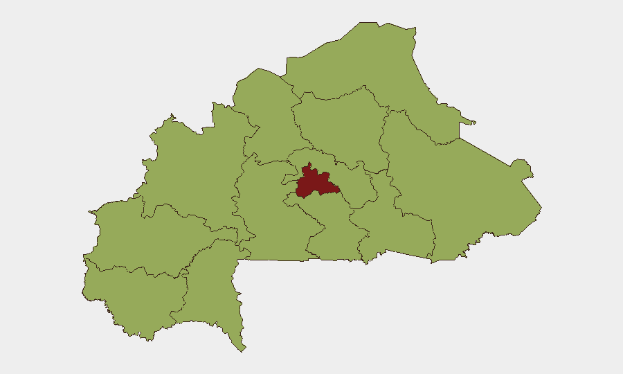
Burkina Faso remains under sustained terrorist and kidnapping pressure, with a composite threat ranking of #18 globally and Centre region posing acute risk (83.5/100). Open-source monitoring over the last 24–48 hours reports no clearly confirmed new kinetic incidents, attacks, or major civil unrest; however, curfews, checkpoints, and counter-terrorism operations remain active nationwide, particularly in high-risk peripheries. The security environment is structurally unstable rather than acutely volatile at this moment, but organizations with personnel or assets in the country face persistent elevated exposure to militant activity, abductions, and armed checkpoints outside major urban centers.
Key Developments
- No new confirmed incidents documented in the 24–48-hour window (25–27 July 2026). Multi-source open-source reporting and real-time social-media monitoring indicate no independently verified attacks, bombings, or large-scale combat exchanges with specific location and date corroboration in this period.
- Curfews and movement restrictions remain in effect across Centre, North, Sahel, and East regions; military checkpoints and identity controls continue on key routes, particularly around Ouagadougou and secondary cities, with no new policy changes reported in the last two days.
- Structural terrorism and kidnapping threat persists. German (Auswärtiges Amt) and Australian (Smartraveller) travel advisories maintain non-travel warnings for Burkina Faso due to active terrorist cells, kidnapping networks, and violent crime; this reflects ongoing operations rather than a discrete new event.
- Earlier July combat activity (30 June–5 July) around Gayéri, Solhan, Sebba, and the Burkina Faso–Niger border remains the most recent documented large-scale exchange; security force posture suggests continued counter-offensives, but no new engagements have been reliably reported since then.
- Centre region dominates threat profile. With a composite risk score of 83.5, Centre significantly outpaces all other regions (53.5 each); militant cells, kidnapping rings, and armed-group activity concentrate in and around the capital periphery and central plateau, driving national exposure levels.
Highest-Risk Areas
Centre region (83.5) stands alone as the critical risk driver, encompassing and radiating from Ouagadougou and surrounding provinces where militant presence, abduction networks, and checkpoint harassment are most concentrated. The nine remaining regions cluster at 53.5, reflecting a nationwide distributed threat—Upper-Basins, Boucle du Mouhoun, Sahel, North, and East are particular concern zones for kidnapping, armed-group activity, and military operations. Risk is highest outside major urban centers; intercity travel and rural/border-adjacent zones carry disproportionate exposure to both militant and state-security checkpoints.
How GeoBit Would Assist
Security teams should deploy AOI Monitoring & Early Warning on Centre and high-risk peripheries (North, Sahel, East) to detect new militant activity, checkpoint patterns, or movement restrictions in near-real time. Intel Sweep, X/Twitter OSINT, and multi-language search across local and diaspora sources provide early signal of emerging incidents, curfew changes, or armed-group movements before they escalate. Routing & Network Analysis supports journey planning for personnel movement, identifying secure corridors and checkpoint-avoidance strategies within the current operational environment.
7-Day Outlook
No imminent major tactical shift is evident, but the security environment will remain elevated and volatile. Personnel and asset security posture should assume sustained exposure to terrorism, kidnapping, and checkpoint friction; travel outside Ouagadougou and Bobo-Dioulasso carries persistent high risk. Monitoring should focus on early detection of new militant operations, curfew expansions, or political instability that could rapidly degrade movement and service-delivery capability.
Highest-Risk Areas — Ranked
| # | State / Region | Risk |
|---|---|---|
| 1 | Centre | 83.5 |
| 2 | Upper-Basins | 53.5 |
| 3 | Boucle du Mouhoun | 53.5 |
| 4 | Central-West | 53.5 |
| 5 | Central-South | 53.5 |
| 6 | Central-East | 53.5 |
| 7 | Waterfalls | 53.5 |
| 8 | Southwest | 53.5 |
| 9 | Sahel | 53.5 |
| 10 | Central-North | 53.5 |
| 11 | East | 53.5 |
| 12 | North | 53.5 |
Sources
Previous Daily Briefs
A new Burkina Faso brief is written every day — each with its own risk map and downloadable CSV. Here's the last week; use the calendar to go further back.
📅 Browse every day by calendar →
Highlighted days have a brief. Tap a day for that day's map & analysis, or “csv” for that day's dataset ($5).
Atlas — our AI intelligence desk — emails them this snapshot personally. Nothing else, no list.