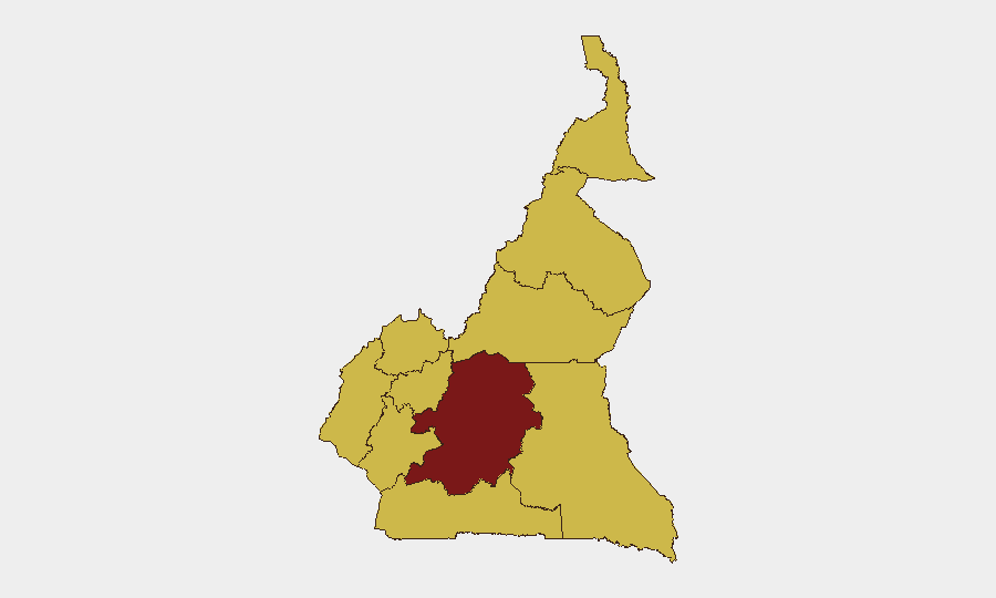
Situation Summary
Cameroon's composite threat score places it at #24 globally, with four tracked events in the last 48 hours spanning militant violence, separatist activity, and urban infrastructure failure. Security operations have intensified across the Far North, Northwest, and Southwest regions in response to confirmed Boko Haram assaults and armed separatist engagements. The Centre region carries the highest sub-national risk (95.5), but active militant pressure is concentrated in the Far North and Anglophone zones, where military reinforcements and checkpoint expansion are ongoing.
Key Developments
- Tourou, Mokolo subdivision, Far North – night of 14–15 July 2026
Boko Haram forces assaulted an advance Cameroonian army post, killing one female civilian, wounding at least four soldiers, and seriously injuring a 15-month-old child. Attackers seized military equipment before withdrawing. This follows a repelled incursion in the same locality less than 24 hours earlier (13–14 July), in which two Boko Haram fighters were reported killed.
- Far North Region border areas – 14–16 July 2026
Cameroon's military deployed reinforcements and increased patrols on key roads and in vulnerable communities around Mokolo and Mayo-Tsanaga in direct response to the 14–15 July assault, indicating a deliberate escalation of counter-insurgency posture in this sector.
- Northwest Region – Monday, mid-July 2026
Armed forces conducted a conventional military operation against separatist fighters, killing two combatants. Small-arms engagements in the Anglophone regions remain active.
- Northwest and Southwest Regions – mid-July 2026 (last 48 hours)
Security services reinforced patrols and checkpoints on major roads and around strategic sites in both regions, citing ongoing separatist threats and reflecting heightened operational tempo across the conflict-affected Anglophone zones.
- Douala, Littoral Region – 18 July 2026
A three-storey residential building partially collapsed during heavy rainfall, killing at least six people (including three children) and injuring six others. The incident underscores structural-safety risks in Douala's high-density urban areas during seasonal weather events.
Highest-Risk Areas
The Centre region dominates the sub-national ranking at 95.5, though it hosts the capital and government infrastructure rather than active militant theatres. Operational risk is concentrated in the Far North (Boko Haram), Northwest, and Southwest (separatist activity), all tied at 65.5. The Far North's repeated assaults by Boko Haram in a 48-hour window and the military's concurrent reinforcement signal an unstable equilibrium in the Tourou–Mokolo corridor; the Anglophone regions' checkpoint expansion reflects security authorities' assessment of persistent separatist mobilization. Littoral's infrastructure vulnerability, demonstrated by the Douala building collapse, adds non-militant risk to the commercial hub.
How GeoBit Would Assist
Security teams monitoring Cameroon should deploy AOI Monitoring & Early Warning on the Far North border sector (Tourou, Mokolo, Mayo-Tsanaga) to detect Boko Haram activity patterns and military response timing; pair this with Conflict & Military tracking (force movements, checkpoint locations) to anticipate operational shifts. Routing & Network Analysis supports duty-of-care planning by identifying safer transit corridors through Northwest and Southwest, while Satellite & Imagery analysis can validate infrastructure integrity in Douala and other urban centres before staff deployment or site visits.
7-Day Outlook
Boko Haram activity in the Far North is likely to persist given the 14–15 July assault's apparent success; military reinforcements may deter further immediate incursions but will not eliminate the threat. Separatist operations in the Anglophone regions are expected to remain at low-intensity levels with intermittent clashes. Urban infrastructure risks in Douala will increase if heavy rains continue into the wet season; physical-security teams should reassess facility integrity.
Highest-Risk Areas — Ranked
| # | State / Region | Risk |
|---|---|---|
| 1 | Centre | 95.5 |
| 2 | Northwest | 65.5 |
| 3 | Southwest | 65.5 |
| 4 | West | 65.5 |
| 5 | Littoral | 65.5 |
| 6 | Adamawa | 65.5 |
| 7 | South | 65.5 |
| 8 | Far-North | 65.5 |
| 9 | North | 65.5 |
| 10 | East | 65.5 |
Sources
Previous Daily Briefs
A new Cameroon brief is written every day — each with its own risk map and downloadable CSV. Here's the last week; use the calendar to go further back.
📅 Browse every day by calendar →
Highlighted days have a brief. Tap a day for that day's map & analysis, or “csv” for that day's dataset ($5).
Atlas — our AI intelligence desk — emails them this snapshot personally. Nothing else, no list.