Situation Summary
Colombia maintains composite threat score of 54 (global rank #35) with 256 tracked events, reflecting persistent fragmentation across multiple threat vectors—political instability, armed group activity, and criminal organization competition. Recent signal patterns (July 5–7) show elevated institutional discord, including congressional, senatorial, and executive public statements alongside armed group conventional force activity and military mobilization. The security trajectory remains volatile but not acutely destabilizing; however, concentration of risk in Meta, Nariño, and Capital District demands targeted monitoring.
Key Developments
GeoBit event signals logged on July 5–7 include:
- Political friction (nationwide, July 5–7): Multiple parliamentary, senatorial, and presidential public statements, coupled with politician-vs-cabinet friction and regime rejection signals, suggest ongoing policy or governance tensions without immediate territorial or security incident confirmation.
- Armed group conventional military activity (location and specific incident unconfirmed, July 5): Event taxonomy flags armed group force deployment; operational details and geographic specifics not yet corroborated in available OSINT.
- Military/naval mobilization (location unspecified, July 7): Naval force movement recorded; intent and area of operations not yet clarified.
- Institutional disapproval (nationwide, July 6–7): Colombian authorities and legal voices (lawyer) flagged disapproval signals, consistent with political contestation rather than security emergency.
Data limitation: Live web research for July 5–7 does not yield independently verified, specifically dated incident details (locations, casualties, operational scope) needed for tactical risk briefing. Reliance on signal taxonomy alone without corroborated source confirmation limits granularity.
Highest-Risk Areas
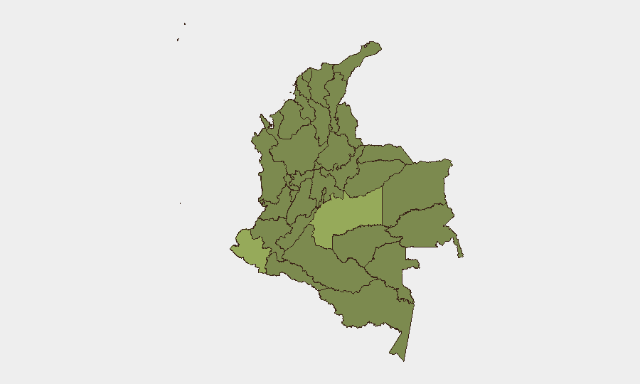
Meta Department (risk 56.9) ranks highest and significantly exceeds all other regions; it anchors the national threat profile and warrants dedicated asset/personnel review. Nariño (41.9) and Capital District (38.5) form the second tier and likely reflect armed group presence (southern border dynamics, coca cultivation, trafficking) and urban political/institutional instability respectively. Atlántico and Valle del Cauca (both 29.4) represent Caribbean coast and Pacific corridor risk; Magdalena, Bolívar, and La Guajira (28.5, 28.5, 27.7) reflect port, mining, and contraband pressure points. The southern and coastal concentration suggests cartel/trafficking organization competition and armed group territorial control as primary drivers, while Capital District risk is rooted in political fragmentation and protest potential.
How GeoBit Would Assist
AOI Monitoring & Early Warning on Meta, Nariño, and Capital District enables persistent watch for armed group movement, military response, and critical infrastructure threats with real-time alerting. Network & Actor Analysis maps cartel, armed group, and state security relationships to forecast escalation triggers. Conflict & Military battle mapping and force-structure tracking clarifies armed group disposition and military posture in high-risk departments, informing duty-of-care decisions on personnel safety and supply-chain routing. Intel Sweep (multi-language OSINT, Telegram/X, local news) backfills gaps in English-language reporting and flags emerging political or security inflection points within 6–12 hours of incident occurrence.
7-Day Outlook
Political institutional stress appears manageable in the near term but may drive localized protest or security-force deployment in Capital District. Armed group activity in Meta and southern departments (Nariño, Putumayo, Caquetá) will likely persist at current operational tempo absent major enforcement surge. Maritime mobilization warrants 48-hour tracking for Caribbean contraband enforcement or coastal security escalation.
Highest-Risk Areas — Ranked
| # | State / Region | Risk |
|---|---|---|
| 1 | Meta Department | 56.9 |
| 2 | Nariño | 41.9 |
| 3 | Capital District | 38.5 |
| 4 | Atlántico Department | 29.4 |
| 5 | Valle del Cauca Department | 29.4 |
| 6 | Magdalena Department | 28.5 |
| 7 | Bolívar Department | 28.5 |
| 8 | La Guajira | 27.7 |
| 9 | Caldas | 27.7 |
| 10 | Archipiélago de San Andrés, Providencia y Santa Catalina Department | 26.9 |
| 11 | Putumayo Department | 26.9 |
| 12 | Caquetá Department | 26.9 |
Sources
Previous Daily Briefs
A new Colombia brief is written every day — each with its own risk map and downloadable CSV. Here's the last week; use the calendar to go further back.
📅 Browse every day by calendar →
Highlighted days have a brief. Tap a day for that day's map & analysis, or “csv” for that day's dataset ($5).
Atlas — our AI intelligence desk — emails them this snapshot personally. Nothing else, no list.