Situation Summary
Djibouti remains a lower-threat environment globally (#88, composite score 18) with no tracked security incidents in the past 48 hours within its borders. However, regional maritime instability—particularly piracy in the Gulf of Aden and waters off Somalia—poses direct operational risk to Djibouti's port, shipping lanes, and logistics hubs. U.S. Embassy shelter-in-place directives (lifted 16 August, reinstated 17 August in response to regional missile and drone activity) underscore elevated caution posture tied to broader Horn of Africa tensions rather than Djibouti-specific threats.
Key Developments
- Gulf of Aden (international waters, Djibouti Code of Conduct region) – 21 August 2026: A tanker was hijacked by six armed individuals after issuing a distress call and diverted toward Somalia; UK Maritime Trade Operations (UKMTO) issued heightened caution warning to all vessels transiting the region, directly affecting maritime corridors serving Djibouti Port.
- Off Somali coast (DCoC area) – 17–21 August 2026: Cameroon-flagged cargo vessel MV Lutuf was boarded and seized by Somali pirates approximately 4–4.5 nautical miles south of Mareeyo; crew reported safe; incident prompted policy response by DCoC member states.
- Djibouti Code of Conduct Steering Committee – 19–21 August 2026: Member states (including Djibouti) voted to establish a Combined DCoC Task Force in response to renewed piracy cluster; decision may trigger increased naval/patrol activity in sea lanes serving Djibouti and affect maritime routing and operations.
- Regional piracy surge – 21 August 2026: Media reports confirm at least two additional tanker seizures off Yemen/Somalia with 22 Indian crew members among those hijacked; at least six vessels currently held and over 100 hostages in ongoing regional piracy cases, indicating sustained maritime-sector pressure.
- U.S. Embassy advisory status – 16–17 August 2026: Shelter-in-place directive lifted 16 August, then reinstated 17 August due to potential incoming threats from regional missile and drone activity; normal operations under caution posture, no incident materialized.
Highest-Risk Areas
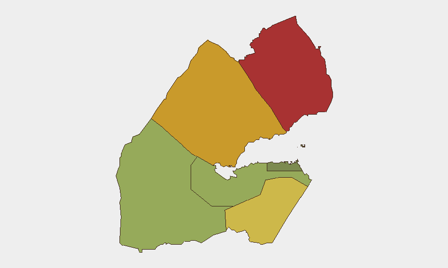
Obock (risk 78) and Tadjourah (risk 72) dominate the sub-national threat profile, both located in Djibouti's north and northeast bordering Eritrea and Somalia—regions exposed to cross-border militia activity, weapons trafficking, and maritime piracy operations. Ali Sabieh (risk 65) in the west faces similar transnational pressures along the Somaliland border. By contrast, Djibouti City and the capital region (risk 35) remain lower-risk, though they are operationally dependent on the Gulf of Aden and Indian Ocean corridors now seeing elevated piracy activity—creating indirect supply-chain and port-security exposure for corporate and diplomatic assets concentrated there.
How GeoBit Would Assist
Security teams should employ Maritime & Aviation tracking to monitor vessel transits to/from Djibouti Port and flag anomalies in Gulf of Aden/Indian Ocean corridors; AOI Monitoring & Early Warning on Obock and Tadjourah to detect cross-border militia or weapons-trafficking signals; and OSINT fusion (X/Twitter, Telegram, regional agency feeds) to corroborate piracy warnings and DCoC task-force activity in real time. Routing & Network Analysis can identify safer maritime and air corridors and alternative supply-chain pathways during high-risk periods.
7-Day Outlook
Maritime piracy risk will likely remain elevated through late August as the new DCoC Task Force mobilizes and shipping companies adjust routing. Regional missile/drone activity signals suggest U.S. and allied personnel will maintain heightened caution posture, though Djibouti itself faces low likelihood of direct military action. No major civil unrest, protests, or terrorism events are forecast for the capital or lower-risk zones in the next seven days.
Highest-Risk Areas — Ranked
| # | State / Region | Risk |
|---|---|---|
| 1 | Obock | 78 |
| 2 | Tadjourah | 72 |
| 3 | Ali Sabieh | 65 |
| 4 | Arta | 48 |
| 5 | Dikhil | 42 |
| 6 | Djibouti | 35 |
Sources
Previous Daily Briefs
A new Djibouti brief is written every day — each with its own risk map and downloadable CSV. Here's the last week; use the calendar to go further back.
- August 19, 2026
- August 17, 2026
- August 15, 2026
- August 13, 2026
- August 11, 2026
- August 9, 2026
- August 7, 2026
📅 Browse every day by calendar →
Highlighted days have a brief. Tap a day for that day's map & analysis, or “csv” for that day's dataset ($5).
Atlas — our AI intelligence desk — emails them this snapshot personally. Nothing else, no list.