Situation Summary
The Dominican Republic faces persistent but contained security challenges driven primarily by street-level crime, gang activity, and irregular migration enforcement rather than political instability or armed conflict. No major civil unrest or infrastructure disruption has been reported in the last 24–48 hours. Active police and military operations across multiple provinces indicate sustained government security posture, with homicide rates remaining within documented historical ranges (7.09 per 100,000 nationally as of 24 July). Risk remains localized and concentrated in urban centers and border regions.
Key Developments
- Santo Domingo (Ensanche Naco, Av. Abraham Lincoln) – late July: A woman died in hospital following a shooting at Plaza Castilla; National Police report the suspect remains at large and investigations are ongoing.
- Nationwide police operations – last 24 hours: Policía Nacional arrested 187 individuals and seized seven firearms in preventive operations, including cases linked to kidnapping and domestic violence.
- Border provinces (Dajabón, Elías Piña, Valverde, Montecristi) – recent operations: Army patrols (ERD) and migration authorities (DGM) detained 37 undocumented Haitian nationals in separate interceptions near Los Memisos–Sabana Mula, Los Restauradores (Mao), and Montecristi; one vehicle pursuit near Aminilla ended in a canal crash with 10 detainees.
- National migration enforcement – last 24–48 hours: DGM deported 800 irregular foreigners and detained 955 people across operations spanning 24 provinces, including Pedernales, Dajabón, Elías Piña, Valverde, Santiago, La Altagracia, and Santo Domingo, reflecting large-scale enforcement activity.
- Homicide trend (week to 24 July): Fuerza de Tarea Conjunta bulletin reports 29 territories with single-digit homicide counts and sustained national rate of 7.09 per 100,000—consistent with ongoing but stable lethal-violence levels.
Highest-Risk Areas
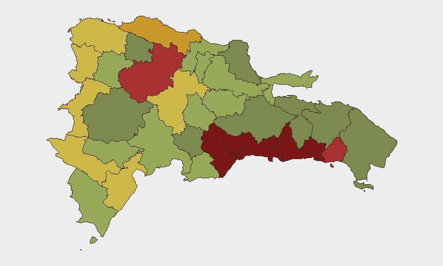
Santo Domingo (risk 92) and the Nacional District (risk 88) drive the composite threat ranking, reflecting high-volume street crime, armed robbery, and gang-related violence in these urban centers. Border provinces—Dajabón (68), Elías Piña (70), and Barahona (65)—rank elevated due to irregular migration, smuggling networks, and associated border instability. San Cristóbal, San Pedro de Macorís, and La Romana (85, 83, 78 respectively) also reflect urban crime concentrations. Mid-tier provinces with lower rankings remain secondary concern areas but warrant monitoring for spillover effects from enforcement operations.
How GeoBit Would Assist
Security teams should employ AOI Monitoring & Early Warning to track persistent hotspots in Santo Domingo and border provinces, with real-time alerting on crime and enforcement incidents. Multi-language OSINT fusion and corroboration (Twitter/Telegram, official bulletins, media sources) enables rapid verification of localized incidents and official operations, reducing false-positive risk. Network & Actor Analysis and conflict/crime search capabilities support mapping of gang and smuggling networks operating across high-risk provinces, informing duty-of-care protocols for personnel in those regions.
7-Day Outlook
Street crime and migration enforcement are expected to remain the primary drivers of Dominican Republic risk over the next week. Government security operations will likely continue at current intensity across border and urban zones. Personnel and asset security should remain focused on localized urban crime precautions rather than preparing for systemic destabilization.
Highest-Risk Areas — Ranked
| # | State / Region | Risk |
|---|---|---|
| 1 | Santo Domingo | 92 |
| 2 | Nacional District | 88 |
| 3 | San Cristóbal | 85 |
| 4 | San Pedro de Macorís | 83 |
| 5 | La Romana | 78 |
| 6 | Santiago | 76 |
| 7 | Puerto Plata | 72 |
| 8 | Elías Piña | 70 |
| 9 | Dajabón | 68 |
| 10 | Barahona | 65 |
| 11 | Independencia Province | 64 |
| 12 | La Vega | 62 |
Sources
Previous Daily Briefs
A new Dominican Republic brief is written every day — each with its own risk map and downloadable CSV. Here's the last week; use the calendar to go further back.
📅 Browse every day by calendar →
Highlighted days have a brief. Tap a day for that day's map & analysis, or “csv” for that day's dataset ($5).
Atlas — our AI intelligence desk — emails them this snapshot personally. Nothing else, no list.